Christmas was once again spent away from family this year, but this year would at least be exciting. One of my friends and I decided to head west from Glasgow to Oban with some stops along the way. When I moved back to Glasgow from Australia a year ago, a friend of one of my friends was looking at a wall map of the British Isles in my flat, pointed to an area south of Oban, and said, "You must go here, to Kilmartin Glen." He said that Kilmartin Glen is one of the most overlooked destinations for anyone interested in Scottish history and neolithic sites. So, after a day of recovering form boxing day laziness, we headed out from Glasgow.
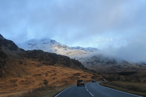
Driving along the A83 between Loch Lomond and Inverary
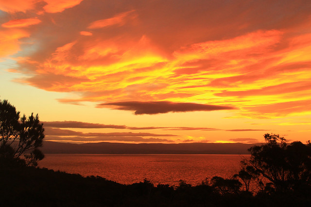
Winter is an absolutely beautiful time to visit Scotland. Sure, the days are incredibly short, but the snow on the hills makes it unlike anywhere else. Once away from the main cities, the roads get narrow and windy, which makes for getting anywhere quickly quite tricky! It took us a while to get out to Kilmartin Glen, via a coffee stop in Inverary, but a little after noon we pulled into our first stop, Dunadd, which was the first site of the first kings of Scotland, having been in use since the Iron Age. On the little hill above the glen is a rock with some footprints carved into them, possibly where the kings looked out - I imagine much like Mufasa and Simba from Pride Rock :)
A little bit further down the road are a series of standing stones dating back 5,000 years. We missed the winter solstice only by a few days, but it's pretty amazing how these stones would have lined up with the setting sun, even after 5,000 years! I'm often really amazed by how after thousands of years, and with all of our modern technology and knowledge, we still have no real idea what these stones or circles were used for! And while not as grand as the Ring of Brodgar in Orkney or as circular as the Drombeg Stone Circle in southwest Ireland, the stones are just as enigmatic, and there are a lot of them, including one site where five stones make an X figure in a field, apparently a very unusual arrangement. Starving, we stopped in at the Kilmartin Hotel and had a tasty pub supper before exploring the curchyard across the street with brilliant scenery looking down the Glen.
There were still a few things we wanted to see before it got dark and before we got to Oban, and even though it was only 3 o'clock in the afternoon, we were running short on daylight, so we hit the road again, winding around the coast, to the Bridge over the Atlantic. To be fair, this is a very nice looking stone bridge, arching high over a small tidal waterway, technically part of the Atlantic Ocean, separating the Scottish mainland from the small Isle of Seil. Apparently nowhere else (maybe in Scotland) is there a bridge over the Atlantic, so it is only here you can say you've "driven across the Atlantic Ocean." Not really much to see, we kept on to the small town on Seil of Ellenabeich, an old slate mining town that now consists of three rows of whitewash cottages. A beautifully small town that I would have liked to have stayed in a bit longer. Would have been a great place to write up my PhD thesis! While in Ellenabeich, the sun went down and we didn't want to be stuck on unlit country roads for too long, so we headed in to Oban, checked into our hotel, and met up with one of my Uni friends who was home visiting family for the holidays.
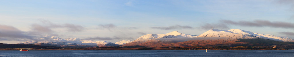
Snow-capped mountains on the Isle of Mull with Duart Castle in the foreground from the ferry from Oban to Mull.
We got up early the next morning, a brilliantly clear but chilly morning, to catch the ferry from Oban out to the Isle of Mull, a rugged island about an hour offshore from Oban. The views from the ferry back to the mainland of snow capped mountains were amazing, not to mention the snow capped peaks of Ben More, the only Munro on Mull. A little note for visiting Mull in the winter: Don't plan on relying on public transportation, especially on a Sunday! We were lucky to have a Range Rover, so the small single-track roads and ruts of Mull were a piece of cake, but be careful if you have a smaller car not to go off the edge of the road or you will get stuck! We headed immediately out to the westernmost point of Mull, a town called, Fionnphort, where we waited for the quick ferry out to the small Isle of Iona. Again, visiting in the winter and on a Sunday, you run the risk of either the ferry not running, or only making one trip out to Iona, but not back, so it's suggested you call the portmaster on Mull the day before to make sure the ferries are running!
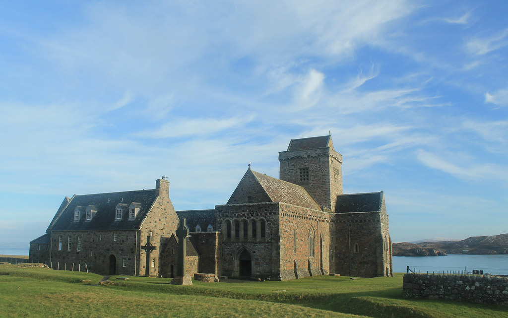
Iona Abbey
The sky was crystal clear, and though it wasn't windy, it was really cold! But while waiting for the ferry we did get to see a small fishing boat loading up for the day, and it must be quite a regular occasion because there was a seal who sidled right up to the boat begging for a bit of breakfast! The ferry finally arrived and we walked on, making sure to ensure it would come back from Iona! Now, Iona is a beautiful little island and I wish we had more time to spend there, but with the two hours we did, we made sure to walk over to the famed Iona Abbey, the former Catholic monastery where the Book of Kells was written. The Abbey survived Viking raids as well as the Protestant Reformation, and is now part of the Church of Scotland. So many tourists come out to Iona in the summer, it was nice to experience the island in winter when even the hostels were closed for the season! BUT, if you go on the weekend, you don't have to pay to get in to the grounds! We took a little walk up to the highest point on Iona, Dun I, for some breathtaking views to Mull and so many other Inner Hebridean islands.
Running short on time, we headed back to the ferry and crossed back over to Fionnphort, accompanied by dolphins jumping out of the water and playing in the wake of the ferry! Back in the car, we decided to take the small winding road around the rest of Mull. Now, I thought the road from the Mull ferry to Fionnphort was small, but it was nothing compared to the B8035, which was tucked right along the coast with rocky cliffs on one side, but provided amazing scenery, especially during sunset on such a clear day! The B8035 turns onto the B8073 and the road climbs up some very steep hills that any small car would have some trouble getting up! If you're in a small car, you definitely want to take the B8073 counterclockwise from Tobermory where it will be easier to go down these roads than up. Daylight was nearly gone as we arrived to Calgary Beach in the small locality of Calgary, the same that the Canadian metropolis is named after! But we couldn't stay long since the sun had now set and we still had about 30 minutes to drive to Tobermory for a quick fish dinner (not many places open on a winter Sunday), very quick because we had to get back down to the ferry docks to catch the last ferry back to the mainland.
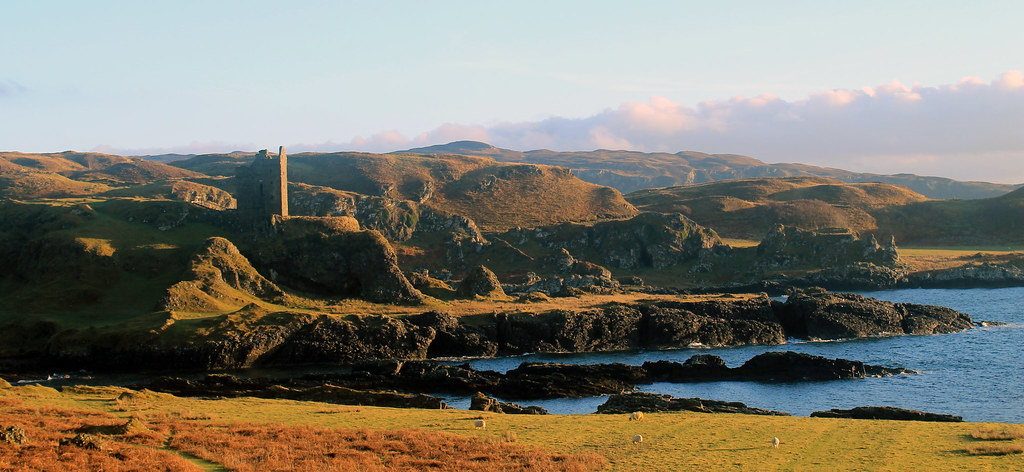
Gylen Castle on the southern end of Kerrera
The following morning was yet again a clear day on the western Scottish coast, though much colder! Not wanting to waste time, we grabbed some breakfast and went to the small local ferry from Oban out to the small island, Kerrera. A privately-owned ferry, you signal the owner that you want a ride by sliding a big panel open on the mainland, revealing a big black square, and upon seeing it, the ferryman comes over to pick you up for the 5 minute crossing. We decided to do the 3.5 hour loop down to Gylen Castle at the southern end of the Island and back. Though not a strenuous walk, it felt long because it was so cold, especially in the shade, but the destination was amazing - a square castle with a small footprint exposed on a tall rocky knob over the coast. The castle was besieged and burned in 1647, though recently the Clan MacDougall began restorations. It's surely not much of a castle, but its position in the grassy hills along the coast sure makes it a great place that we had to ourselves! The rest of the circuit along the west side of the island isn't as scenic, and was a bit mushy underfoot, but there were a few brilliant moments in the setting sunlight over to Mull. Back in time for the ferry back to the mainland, we hopped back into the car and headed back up to Oban to pick up my friend who was coming with us back to Glasgow, and with that we were off back home.
Though I think we lucked out, weather-wise, the weekend was a great and most welcome break from city life in Glasgow, and so easy for a few days! Enjoy the photos:
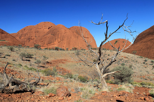
We didn’t have to wake up as early this morning as we did the previous morning, but after an early rise, and a quick pack up of our swags and gear back into the bus, we made the short drive to Kings Canyon in Watarrkah National Park. Kings Canyon lays claim to being the world’s largest canyon, surpassing all others including Arizona’s Grand Canyon, because “technically the Grand Canyon is a chasm.” I had even read that Kings Canyon was even more impressive than Uluru, so needless to say, my expectations were very high!
From the parking lot, Adam pointed out the canyon which cuts its way through the sandstone ridge to the north, and to the trail that we were taking which follows the rim of the canyon. Looking at it from the parking lot, it was clear that my expectations of grandeur were going to be dashed. Semantics aside, the canyon is definitely not bigger than the Grand Canyon (not by a long shot!) and in my opinion, not more spectacular than Uluru.
Panorama of Kings Canyon in Watarrka National Park
With that said, Kings Canyon is marvelous! The trail heads up Heart Attack Hill to the top of the rim and winds in and out and between impressive sandstone formations that have weathered over time into these dome-like features. Erosion along joints – natural fractures in the rock – wore down the rock in grid-like patterns and some of these more deeply-eroded joints are what separate one dome from the next. And in the extreme case of Kings Canyon, stream erosion cut down hundreds of metres into the sandstone carving out a spectacularly beautiful canyon filled with eucalypts and other green trees. You might even recognise the landscape of Kings Canyon if you’ve ever seen the seminal Australian film, The Adventures of Priscilla Queen of the Desert as this is where the shot of the three drag queens stand on the Canyon’s edge in their fabulous dresses and feathery headwear!
Dome structures created by erosion along joints in the sandstone dot the
landscape of Kings Canyon in Watarrka National Park
The trail eventually takes you to the narrowest part of Kings Canyon where you descend a few flights of stairs to The Garden of Eden, an aptly named oasis where water collects in large permanent water holes spanning the narrow canyon width with towering rock cliffs rising above your head. Palms and more tropical gum trees fill the lush Garden in stark contrast to the scrubby and white ghost gums growing up on top of the canyon. The ponds were a great place for a small lunch and break from the sun, but soon enough we headed up another flight of stairs and continued to an amazing canyon lookout where we could belly up to the edge of the canyon and look straight down the cliff faces!
The trail finishes by coming down the mouth of the canyon opposite Heart Attack Hill and those of us at the front of the group lamented as we waited for the stragglers who were taking photos of every single flower, rock, small lizard, spider, or whatever they could find. Adam was about at his wit’s end trying to keep us on schedule, but we eventually mustered back at the bus and we began the 6-hour drive back to Alice Springs.
Looking up the trunk of a ghost gum in Watarrka National Park
We had yet to use the bus’s 4WD capabilities, but instead of taking the paved road back to the Stuart Highway via the Lasseter Highway, we bounded off the pavement making a bee-line straight back to the Stuart via a series of dusty, dirty, bouncy, bumpy dirt roads that no normal vehicle would survive! It was great fun and the vibrating floor provided for a nice foot massage after three days of intense walking! Everyone seemed to be enjoying it except, of course, for the Canadian fashionista who clearly had no concept of what four-wheel-driving was all about. At one point, the bus came to a stop as Adam had to get a clear look as to how best to navigate through an area of soft sand. The fashionista opened her eyes as we stopped, looked out the window and in a moment that defies all logic turned to me and asked, “Is this Alice Springs?” There were no buildings to be seen anywhere around us and we’d only been on the road for a few hours, and in disbelief at her question just stared at her and shook my head. “We’ve still got at least three hours,” I said. She just scoffed and started getting all worked up again at how annoying it was that we weren’t there yet, and what was this bumpy road? She couldn’t even get a good nap! While she was a very nice person, surely with good intentions, I could not wait to get away from her negative attitude. It just astounded me that someone could be so unprepared and not have even the slightest idea of what she was signing up for when she booked her trip. She was a trooper and did everything the rest of us did with a smile, and a joke, and funny stories, but I was glad that in a few hours time, I was not going to have to listen to her complaints ever again!
The rest of the drive back to Alice Springs was pretty uneventful. We didn’t make any more stops, and we didn’t see any more wildlife, but that was alright. Once we were back on the paved road everyone started to nod off. Being on a trip for a few days, with the same people day-in and day-out can be tiring when you know who you’re with, but when personalities don’t match, 3 days can sometimes feel much longer!
Back in Alice Springs, everyone was dropped off at their hotels and hostels and I’m sure no one wanted anything more but to take a much-needed shower and just a bit of quiet alone time for a short while! I know I enjoyed mine! That night, though, we all reconvened at a pub for tour-discounted dinner and beers. It was sort of the last-hurrah as we all talked about our amazing three days in the Outback and talked about what our next planned adventures would be.
It was overall, a great three days of good company, amazing scenery, rich culture, and fun. It made me realise that organised tours and playing backpacker can be really fun, and sure, you might not see those people again, you all shared an experience, and that is really what traveling is all about, and this was no exception. An amazing three days were now over and I had one more night in Alice Springs before my flight left the next morning.
The morning of my flight, I had a few ours left to explore bits of Alice Springs and I walked to the café at the Olive Pink Botanic Garden across the River Todd. It is a much longer walk than it looks on the map, but the café was really good, and the botanic gardens were nice for a quiet morning before flying back to Sydney, re-entering the busy city life. A quick walk up the hill in the Botanic Gardens gave me one final glimpse of the dry, but brilliant landscape that is the Northern Territories and I’m already looking forward to the day that I return there.
Just like watching the swirling colours of the sunset on
Uluru the night before, watching the sunrise behind Uluru, illuminating its
neighbouring rock formation, Kata Tjuta (better known as The Olgas) is not to
be missed! Our tour was woken up nice and early in the pitch black and chilly
cold. We quickly collected our belongings and rolled up our swags, and
clambered into the tour bus for a 40-minute drive west to a viewing platform
bang in the middle of the two amazing rock formations.
The sunrise in the east behind Uluru
The Olgas are in some ways more impressive than Uluru,
albeit being much less known (though they feature prominently in the opening
sequence to the Disney film The Rescuers
Down Under). Whereas Uluru is one massive rock, Kata Tjuta is a cluster of
towering rock stacks with rounded tops, and they are even taller than Uluru!
Geologically, the rocks at Kata Tjuta and Uluru date back over 500 million
years! An ancient mountain range to the west that was created during the
Petermann Orogengy was the source for all of the sand and boulders that were
eroded from the mountains and deposited in a large basin to the east of the
mountains. Over time, these sediments built up and compressed earlier
depositional strata into the sandstone and conglomerates that make up these
rock formations. Over time, further compression and faulting tilted the rocks
such that previously horizontal strata are now almost vertical! While Uluru is
mostly sandstone, large boulders stick out of the steep conglomerate rock walls
of Kata Tjuta.
We stopped at a designated viewing platform for the sunrise
and along with at least one hundred other people waited as the sky started to
lighten up behind Uluru to the east and eventually the sun peaked up over the
horizon, silhouetting Uluru in the distance while illuminating the massive
domes of The Olgas, turning them from shades of gray to pink to orange and
yellow and red. It was a beautiful setting to be sure; however, the sheer
number of people and cameras continuously clicking and the Canadian
fashionista’s complaining about the cold made it much less peaceful as it could
be, though if you could block those sounds out in your head, you could just
imagine what it would have been like to see this every morning without the
nearby roads or viewing platforms, and the whole experience takes you to a
whole new place.
The breaking sunlight on Kata Tjuta (The Olgas)
Again, we had a lot of ground to cover today, and Adam, our
guide, wasted no time in getting us back onto the bus and brought us to the
parking lot at the locality of Petermann. The sun was already high in the sky.
Considering the throng of people at the sunrise viewing platform, there were
amazingly few people here at Kata Tjuta. As much as I loved how quiet it was
here, it’s really too bad that so many thousands of people come all the way out
here, to the middle of this huge country to get on a bus, drive to a viewing
platform, take a few photos, and hop back on their plane. I can’t lie, I also
took a lot of photos, but that is
never enough for me. I couldn’t come all the way out here and not have an experience, to walk through
the landscape, or listen to the wind and birds, or feel the sun’s radiating
heat. I wish more people desired experiences in nature. Maybe we’d all have a
better appreciation for our planet and our environments and become better, more
humble people.
We got off the bus and prepared for a hike through the
Valley of the Winds which takes you from the parking area between some of the
massive rocks that are The Olgas and into the valley protected between them.
Even in August, Australia’s winter, the sun can become too intense to be
outside this far in the Outback, so any hikes should start promptly in the
morning. The Olgas are also incredibly sacred to the local Aboriginal
communities, but curiously, outside of those communities, no one knows why. At
Uluru, there are places where you cannot take photos because of spiritual
significance, but there are signs explaining why the site is sacred. At Kata
Tjuta, nothing is off-limits, but the whole area holds such a deep spiritual
importance that only those in the Aboriginal communities can know what it is!
Down in the Valley of the Winds at Kata Tjuta
The Valley of the Winds is aptly named as air from the
heating rocks rises and pulls in air from the surrounding area that gets
funneled and focused in the valleys between the rocks. It’s not a difficult
walk into the valley, but it is a stunning walk as you work your way between
amazingly steep rock walls with massive boulders sticking out. The valley
itself is made up of gently rolling rocky hills with scrubby vegetation and a
few gum trees dotting it. The walk takes about three hours, provides
spectacular scenery dotted with intricate flowers, and is incredibly peaceful
as anyone you walk past just smiles and nods their hellos, not wanting to ruin
the quiet atmosphere. Because no one knows the real significance of Kata Tjuta,
there almost isn’t much else to say because there is nothing to interpret.
We finished our walk in the late morning and set up our
lunch back at the bus before we packed up at set off for another long drive. We
left Kata Tjuta, passed Uluru once more, and drove the hour or so back to the
Curtin Springs Roadhouse for a quick break before turning off the Lasseter
Highway onto Luritja Road toward Watarrka National Park, home of Kings Canyon.
We stopped once more to collect firewood for that night’s dinner that was a
fun, if not frustrating pit stop. The Canadian fashionista hadn’t been with us
the previous day when we collected firewood and was trying to write postcards
to send back home as our bus drove down the bumpy, dusty dirt road. Trying to
write while driving over washboard road conditions is no easy task, and one
more than one occasion, she would slam down her pen and shout something along
the lines of, “I’m trying to write a postcard! Can’t the bus just stop so I can finish? This is so hard!”
Complaints that received nothing but an annoyed look from me as I asked her
what she expected! My postcards were barely legible because of all of the
bumping around, but I thought it was part of the fun! Not only was I describing
to my family what I was doing, but they could actually see it in the squiggles
in my lettering! She didn’t seem to understand and got even more flustered as
the bus swerved to the left and right. Once we stopped, she finally finished
her postcards (though she took her time, probably not wanting to get her
clothes too dirty with all the red dust) while the rest of us ventured back out
into snake country to collect firewood.
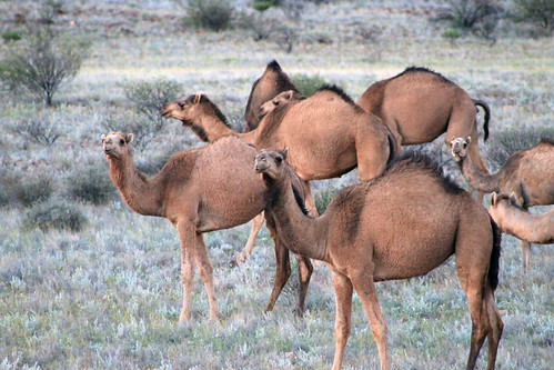
A herd of feral camels in Australia
And we were in store for a treat before we left. As we
loaded back onto the bus, someone spotted a little brownish-gold body bouncing
between the trees and a single solitary dingo sauntered up to the bus! Frankly,
I expected to see more dingoes than we did, but the curious little creature was
the only one we saw and after figuring out we had nothing to offer it, he
quickly sauntered away just as quickly as he came.
Further down the road, we were in for another treat as a
massive herd of wild camels was socialising on the side of the road. Adam
stopped our bus and we all got out, quietly stepping as close as we could to
these amazing creatures without spooking them! There were dozens of them –
mostly adults, but a few young ones, too and they just moved together, minding
their own business. We stayed there, watching them for a while as another
brilliant sunset lowered down toward the horizon. It was just such an odd
sight, seeing the camels, not only because they are just funny looking animals,
but because you just know they aren’t supposed to be there! The wild camel
herds have naturalised so easily to the Australian Outback, their numbers can’t
be culled. They’ve repopulated so well, and from such a small original stock,
that people in the Middle East actually buy their camels back from Australia
because the Australian camel genetics are so pure, they fetch quite a high
price back in the Middle East!
The setting sun was blinding as we drove west to Kings Canyon Resort but we eventually
pulled in to our campsite for the night, got our fire up and blazing, made
dinner, and set up our swags for another chilly night under brilliantly clear
skies in the middle of the Outback.
It was a rough morning trying to wake up on time and be out
in front of the YHA Alice Springs in time to be picked up for my 3-day
adventure in the Outback. Though I originally wanted to rent a 4WD and do the
trek from Alice Springs to Uluru with friends, I wasn’t able to convince any of
my friends to come along on this trip with me and I sure as hell wasn’t about
to tempt fate by doing it on my own because with some of my travel luck, I’d
inevitably get bogged down in some sand, run out of water, and get bitten by a
snake trying to find a cell signal! So I booked a 3-day tour of some of the Outback’s
most famous sites.
WayOutback tours offer a number of trips ranging from 3 days
to over a week, some of which are more rugged than others. The one I’d booked
was “all inclusive” in the sense that all food was provided for, sleeping
arrangements were already made, and all I had to do was show up, sit down in the
bus, and enjoy the scenery. Soon enough, a big…truck? I’m not entirely sure how
to describe it. It was a vehicle that had the front cab of a small semi-truck
and instead of a cargo hold on the back, it had a relatively small coach like a
charter bus with big windows and two seats on either side. The bus accommodated
24 people and was jacked up on big 4WD tires.
Our driver, Adam, helped the two of us being picked up put
our luggage in the storage hold on the back of the bus. It took us a while to
pick up everyone else from their respective hotels and hostels around Alice
Springs, but soon enough we had a nearly full bus with people from all over the
world: an American girl, her father, and her Swedish friend, a hip-hop dance
teacher from Amsterdam, a girl from Glasgow, an adventurous guy from Vancouver,
and your typical handful of German and French backpackers.
The bus was chatty at first as we all were introducing
ourselves and going through the typical banter common amongst backpackers in
Australia, but it was still pitch black out and we had a good 6-hour drive
ahead of us and soon enough everyone was sleeping.
The thing anyone needs to know about the Northern
Territories is that there are very very few towns and everything is incredibly
far apart! When you drive down the highway and come across a petrol station or
bathroom, you stop and fill up and use the bathroom because you never know
where the next one will be. Between the towns are small roadhouses that usually
have a gas station, some hotel rooms, camping spots, toilets, and a bar.
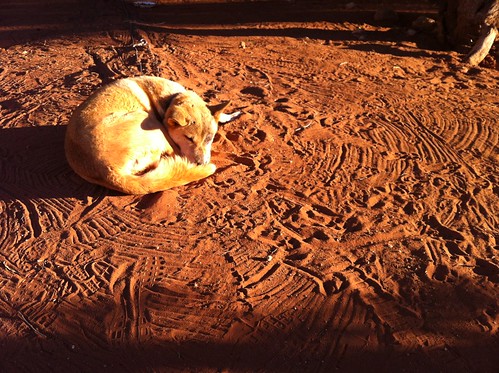
Sleeping dingo at the Stuart's Well Roadhouse south of Alice Springs
Our first stop was at one of these roadhouses, the Stuart’s
Well Roadhouse, and it was the first chance we had to stretch our legs, and
grab a coffee. This roadhouse was unique in that it also had a number of pens
where Australian animals like emu, kangaroos, and various birds were on display
for tourists stopping in. But they also had two of the more unique sights in
the Outback: camels and a dingo. Camels are obviously not native to Australia,
but were imported from the Middle East because of their hardy survivalist
instincts in desert environments and the preferred cargo animal over horses,
which require a lot of water. A transcontinental telegraph cable was built from
Adelaide to Darwin with Alice Springs being used as a transfer point along the
way. Camels were used by the crew that laid down the cable. But like many
non-native animals in Australia, some of the camels escaped and proliferated in
the desert and today there are over one million wild camels roaming Western
Australia and the Northern Territories. Dingoes were also introduced to
Australia over 40,000 years ago and have also adapted and proliferated
throughout the continent and have just recently been described as a separate
canine species and not just a variety of wild dog. The one dingo at this
roadhouse was old and used to tourists, so was not caged up and was pretty
snoozy and docile.
Adam, our driver, didn’t let us linger too long as we still
had a long ways to go. We drove another few hours to the Erldunda Roadhouse for
another bathroom break, and turned off the Stuart Highway onto the Lasseter
Highway toward Uluru.
Most people have visions of Australia’s Outback as being
rocky with lots of sandy deserts, dry eucalypts, and brilliant soils stained
red by the rusting of iron in the dust and soil. These images are spot on what
you actually see and it is beautiful! Nothing but flat land as far as the eye
can see until a few low-lying rocky ridges or mesas rise up in the distance,
like Mt. Conner. But I was surprised at just how green it was! The trees were,
by no means, lush and foresty, but the gum trees here were not as brown and dry
as I thought they would be – really a testament to just how well-suited for
every microclimate in Australia these trees are!
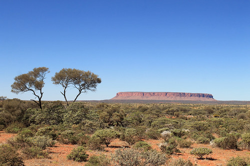
Mt. Conner off in the distance near Curtin Springs
We pulled off the main road shortly before the Curtin
Springs roadhouse to collect some firewood for our campfire that night. Part of
the reason why I booked this particular tour is that while everything was
catered for us, we still had to participate in collecting firewood, preparing dinner,
and washing up dishes. It gives you that little tinge of roughing it! Like
anything in Australia, simple tasks, like collecting firewood carry inherent
dangers. Out here, it was snakes. Some of the world’s most deadly snakes are
found throughout Australia, but exceptionally potent ones here in the Outback.
We had to be very careful when picking up dead wood that no snake was sunning
itself nearby! But soon enough we had our firewood, and we made our pit stop at
Curtin Springs, and carried on west to Uluru.
There were a lot of rocky plateaus and mesas in the distance
along the Lasseter Highway and every time we thought we saw Uluru, Adam would
shake his head and assured us and assured us, “You’ll know when you see it!”
And sure enough, another few hours down the road, the rock loomed into view,
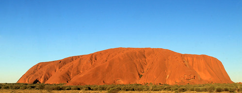
dwarfing any and all other mesas we’d seen! Everyone knows what Uluru looks
like as it’s one of the most photographed rocks in the world. And with good
reason! It’s the world’s largest monolith – or single rock, and it juts up from
the flat Outback surroundings to over 300 m in height. We kept driving closer
and closer and Uluru kept getting bigger and bigger. Finally, we pulled into
our campsite in Uluru-Kata Tjuta National Park.
I couldn’t wait to get up close with the massive rock, but
it was going to have to wait a bit. A few more people were joining our tour,
but were flying directly in to the airport at Uluru, rather than Alice Springs,
so Adam gave us directions for lunch and he left to pick up the others. Soon he
came back with a French family that had a few kids with them, and a blonde girl
from Canada who was finishing up teaching fashion at a school in the Melbourne
area. I’m not entirely sure if she knew what she was signing up for. Everyone
else was dressed in hiking and outdoor gear and those of us who’d collected
firewood were already covered in dust, whereas the Canadian fashionista rocked
up in a flowy sequined top, hair done up like a pro, and flip flops more
appropriate for a cocktails near the beach than heavy walking in the Outback!
With lunch in our stomachs, Adam gave us the cultural
sensitivity talk about Uluru. The rock features in numerous Aboriginal stories
about Tjurkupa – the creation time of the world – and is a very sacred site as
it is the birthplace of the Anangu people who still reside at Uluru. As
European Australians had a penchant to do, they named the rock after the Chief
Secretary of South Australia (Ayer’s Rock) and it became known as Ayers Rock –
Mount Olga National Park, under the government of the Northern Territories
until 1985 when the park was given back to the traditional owners of the land
and renamed Uluru – Kata Tjuta National Park. One of the most popular things to
do at the park is to climb to Uluru’s summit and there is only one trail to the
top, but because of Uluru’s sacred importance to the Aboriginal communities,
doing the climb is not recommended by any of the tour companies who have access
to the park, though they all allow the tourists the option.
Finally here! Uluru!
As a geologist and someone who loves a good hike, I was
really tempted to do the climb, but when our bus pulled into the parking lot
and we saw a full charter bus-full of tourists swarming up the trail to the
summit and I just felt sick from the blatant disrespect for this sacred site. A
small group from our bus decided to do the hike, and I understand their
decision, but I thought that in the long-run, I’d feel better knowing that I
hadn’t tread on sacred ground without fully understanding its importance to the
local people. Thousands of people do the climb each year and some of them even
feel the need to pick up a little stone and take it home as a souvenir from
Uluru. In the National Park’s Visitor Centre, though, there is a binder full of
letters from people who, after taking the stones from Uluru, experienced so
much bad luck and racked with guilt that they mailed the stone back to the park
in an effort to rid themselves of their curses. These small rocks are now
collectively known as Sorry Rocks.
While the hikers did the climb, the rest of us did the short
Mala Walk to Kantju Gorge. Uluru has a lot of curves creating alcoves along its
base which are perfect for allowing water to pond and gives the appearance of
little oases in the Outback. The Mala Walk took us past a number of sites that
are featured in the creation stories of the local Anangu people. Some of the
rock caves at Uluru’s base contain carvings and petroglyphs that are thousands
of years old. The trail leads you to Kantju Gorge which features a small water
hole at the base of a cascade of steps that have eroded into the steep sides of
the rock over millennia.
By the time we got back to the parking lot, the hikers
hadn’t yet returned, so the rest of us drove around to the Mutitjulu Waterhole
around the other side of the rock where there is an even bigger waterhole and
forms in the rocks tell the story of Kuniya, a python woman who had traveled from
the east. Kuniya’s nephew had been killed by the Liru, poisonous snakes. When Kuniya
arrived, she exacted revenge for her nephew by taking her walking stick and striking
the Liru with it, killing him.
The day was getting on and sunset wasn’t far away. Next to
the Uluru climb, one of the most popular events every day is to watch the
sunset on Uluru. The bright orange sandstone takes on a new life as it’s
shadows and colours change in the dimming light. Our bus pulled into a parking
lot that was just swarming with tour
buses and vans, each with their own cohorts of tourists sitting around
make-shift tables while everyone sipped on champagne and snacked on
finger-foods while watching one of the most beautiful sunsets in the world. The
bright orange rocks faded in and out of various hues of red and pink as the sky
behind it darkened. The shadow of the western horizon slowly works its way up
the rock until the final moment when the only the tip of the rock is
illuminated a gentle pink colour before the shadow envelops the entire rock.
Even with all the people around, I was able to take a little walk down a path
where there were far fewer people and the whole sunset just becomes a peaceful
experience leaving little doubt that this gigantic rock is indeed an intensely
spiritual place.
With the sunset over, we bussed back to our campsite where
some of our group got a campfire started so we could cook dinner while the rest
of us started to prepare our beds. There were large stationary tents at the
site, but the weather was wonderfully mild and we all had the option of
sleeping in swags under the stars. Swags are nothing more than a big canvas bag
that has a rough sleeping pad inside and you then put your sleeping bag in the
swag on the pad. A canvas flap can then be pulled over your head in case it
were to rain. Swags feature heavily in Australian culture, most notably in the
song “Waltzing Matilda” in which Matilda is actually the name of the man’s
swag! I don’t think I ever met a respectable Australian who didn’t have a swag
or hadn’t spent a night in one. Being in the middle of the Outback, at Uluru,
there was, for me, little choice about spending a few nights sleeping under the
countless stars in my swag.
With our stomachs full of food and beer, it wasn’t long
before everyone was comfortably in their swags (or uncomfortably in the case of
our Canadian fashionista!) and fast asleep. It wouldn’t be too long, after all,
before we would wake up at 4 am for our next day’s worth of amazing Outback
experiences!
The morning after our night of no-sleep at the Coles Bay YHA, we woke up with some fresh coffee and breakfast at a wonderful new cafe in "downtown" Coles Bay with great panoramic views of the main mountain range of the Freycinet Peninsula. After we refueled our stomachs and the gas tank, we headed back toward Hobart, but turned off toward the town of Port Arthur out on the Tasman Peninsula.
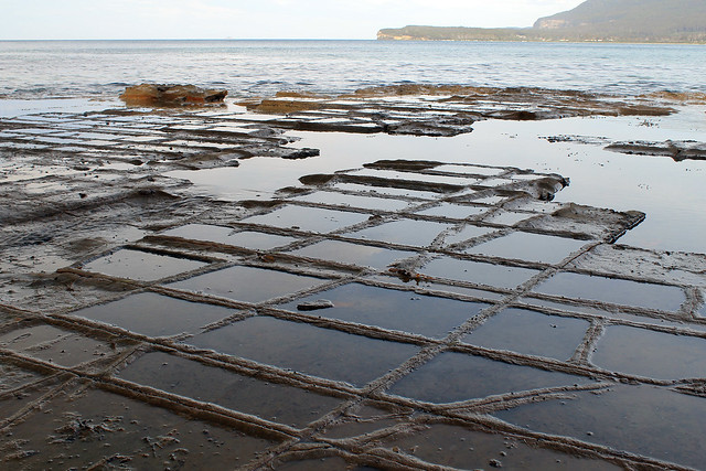
Tessellated Pavement on the Tasman Peninsula coast, Tasmania
Danielle got less sleep than I did the night before and when we reached the area around Eaglehawk Neck - a 100 metre wide isthmus - which has a number of geological sites of interest, she stayed in the car while I walked down to a unique site called the Tessellated Pavement. This rock shelf is exposed along the coast, not much higher than the water level. Hundreds of millions of years ago this location was under a lot of water and only the tiniest of sediments were transported out into the deep ocean. Tasmania was also glaciated at the time and larger rocks and pebbles stuck in iceberg ice floated out to the open ocean and as the ice melted, these larger sediments were dropped down onto the ocean floor. Over time these sediments became rock and various tectonic forces deformed the rock ever so slightly, but enough to crack the rocks, forming joints in three different directions. Today, the rock is exposed to salt weathering and wave action. The rock that is higher than the high-tide level allows salt crystals to grow large enough on the rock surface such that it wears that surface down more quickly than it wears down the joints. This process forms salt pans. Alternatively, the rocks exposed down by the water's edge and below the water's surface is inundated by water so frequently that salt crystals can't grow. Rather, the strong wave action picks up sand and abrades the rock and is funneled along the joints in the rock causing the joints to be more eroded than the rock surface and this creates these loaf-like structures. Both the loaves and the pans are exposed along the Tessellated Pavement and even though it is really a simple geologic site, it was beautifully fascinating.
The Tasman Arch on the Tasman Peninsula
Back in the car we drove across Eaglehawk Neck to the Tasman Arch - a large rock arch formed by wave action forming a cave along the coastal cliffs. Over time the inside of the cave erodes to the point where it is no longer able to support its roof and the ceiling caves in leaving behind the arch over the cave's entrance.
The day was getting on by this point and we were both getting tired. There was no way we were going to make it to Port Arthur, but we were close enough to another awesome destination: The Tasmanian Devil Conservation Park.
While in Australia, I started undertaking a challenge I hadn't expected to take: seeing all of the native Australian wildlife IN THE WILD. I've seen a lot on the mainland including platypus, emu, kangaroos, birds of all kinds, wombats, and echidnas (and I saw kiwis in New Zealand). So while in Tasmania I really wanted to see Tasmanian Devils in the wild. Unfortunately, the Tasmanian devil's populations has drastically dwindled after a contagious facial cancer decimated much of the healthy wild devils. Tasmania is now undertaking drastic measures to preserve healthy Tasmanian devils and save the species from meeting the same fate as the other Tasmanian predator - the Tasmanian tiger which was driven to extinction by European settlers after their arrival. The Tasmanian Devil Conservation Park is playing an active role in preserving the genetic diversity of the healthy Tassie devil population and I figured that spending $35 to see them in the conservation park rather than trying to find one in the wild would be money well-spent. We were not disappointed.
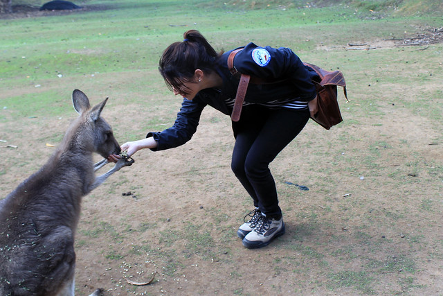
Danielle feeding a kangaroo at the Tasmanian Devil Conservation Park
near Port Arthur, Tasmania
We arrived at the Tassie Devil Conservation Park shortly before a scheduled feeding time and after paying our fees started walking through the park which also has a small family of kangaroos, a few wallabies, quolls, various birds, and four separate Tassie Devil enclosures. We helped the owner of the park feed the kangaroos for a good ten minutes which was SO fun! The kangaroos just hopped over to your hands, holding your hands with theirs, and nibbling the feed out of your hands. Little joeys hopped around excitedly and nuzzled right up to us!
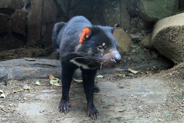
Tassie devil waking up for feeding time at the Tasmanian Devil
Conservation Park
But then it was time for the Tassie devil feeding and the devils knew it! In the one enclosure, right at feeding time, the two brother devils who were at first sleeping in their dens, became quite active and started chasing each other around the pen, snarling, and play-biting each other's snouts. They were quite vicious, but they were so much fun to watch. But then the devils stopped at the same time and looked at us - the owner had opened the cooler and the devils could smell the fresh wombat meat, which he tossed into the pen and the two brothers started a tag as they wrestled the meat away from one another. We must have spent at least 20 minutes watching the devils put on one of the best little shows for us, continuing the trend, as my friend, Danielle said, of, "Tasmania putting on a show just for me!" Once the devils were fed, they retreated to their dens and fell asleep, so Danielle and I walked around the park once more, saying goodbye to all the other residents before leaving.
On the way back to Hobart, we stopped once more at Eaglehawk Neck. The town of Port Arthur on the Tasman Peninsula was once home to one of the worst convict colonies in Tasmania and the British used the natural defenses of this peninsula - most notably this 100 metre stretch of land - to keep the convicts from escaping. Strung across Eaglehawk Neck was a string of vicious dogs chained up and trained to attack any convicts trying to escape the peninsula by land. The modern Tasmanians are using these natural defenses once again, but instead of using them to keep convicts from getting OFF the peninsula, they will be used to create and protect a healthy area of land, totally cleaned of infected Tasmanian devils. Devils are being completely removed from the peninsula and the healthy ones put in quarantine for two years to ensure they do not have the facial tumors. Once it is certain the Tasman Peninsula is cleared of infected devils, a series of triple-barrier fences and canals will be built and dug to keep infected devils from the newly-disease-free peninsula. With the fences and canals in place, quarantined Tassie devils will be reintroduced to the peninsula and if the Tasmanian efforts are successful, it is quite possible that the Tasmanian devils will be saved from extinction!
We were happy to have experienced the Tasmanian Devil Conservation Park, and now having crossed the devils off my must-see list, we began the drive back to Hobart where we readily crashed upon arrival at Danielle's apartment, exhausted from our two-day excursion up Tasmania's east coast.
After a quick night in Hobart, my friend, Danielle, and I piled our things into her car and started our drive up the east coast of Tasmania. Our destination was Wineglass Bay in Freycinet National Park. When I first moved into my current apartment, my flatmate strongly suggested (no, he told me it was a must) that I go to Freycinet National Park because Wineglass Bay was so stunning it was just not to be missed!
Fishing boats in Bicheno Harbour, Tasmania
Well, it took us a few hours to even get close, but we stopped a few times on the west side of Great Oyster Bay (west of the Freycinet Peninsula) for some photo ops and then drove past the Freycinet turn-off, continuing on up to the small seaside town of Bicheno. Not much ever seemed to be going on in Bicheno, but it sure looked like the perfect place for a vacation home. It still boasts a small fishing industry and some of the fishing boats were anchored offshore.
We stretched our legs along the waterfront for a few minutes and I was fascinated by the granite rock exposures along the beach - mostly because they had HUGE orthoclase feldspar mineral crystals - some as big as my finger! The tidal pools between the rocks were filled with little red sea anemones that twisted in the water as the waves came in and out. Bright orange lichens grew on the rocks, though we'd see more impressive lichens later on. We had a bit of fun posing in the dinghies pulled up on the harbour docks but soon headed back to the town and enjoyed a really good little lunch at a pizza cafe called, Pasini's.
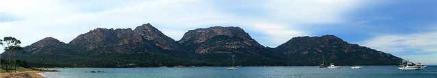
Back in the car we drove south and headed down the access road to the small town of Coles Bay and the entry to Freycinet National Park. While many of Australia's national parks are essentially small tracts of land set aside solely for recreation without many stunning or staggering landscapes or ecosystems, Freycinet is different. Like the Blue Mountains, Royal, Uluru, Daintree, and Kakadu National Parks, Freycinet offers a spectacular mountain landscape with a few tall granite peaks with sparse vegetation growing up the slopes. As we turned the corner and the first view of Mt. Amos and Mayson loomed into view, my jaw hit the floor! I could already tell why my flatmate told me this was a park not to be missed!
Freycinet National Park seen from Coles Bay, Tasmania
We checked in to our hostel (the YHA in Coles Bay - which has impressively thin walls with two very loud groups of backpackers partying late through the night - avoid at all costs) and drove to the car park at the base of the trail to Wineglass Bay. It was late in the afternoon and we had limited time before the sun set, so we had to hurry a bit!
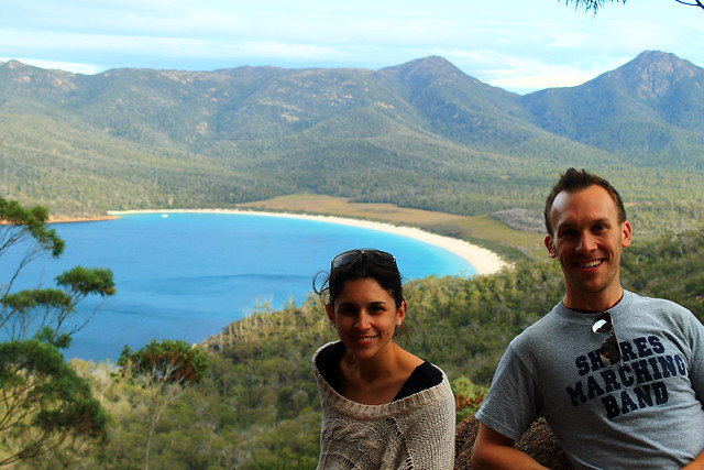
My friend Danielle and me at the Wineglass Bay Lookout in
Freycinet National Park, Tasmania
The trail is well-traveled up to the Wineglass Bay lookout and winds its way through large granite boulders and banksia and gum bush. We stopped at the lookout and had amazing views of Wineglass Bay which is an inlet coming in off of the Southern Ocean ending in an impressively wide beach and some of the bluest of blue waters I've ever seen!
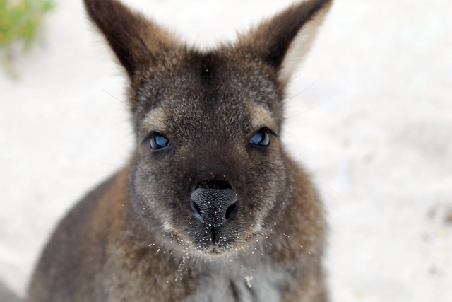
Not wanting to miss out on anything Danielle and I continued down the trail to the beach and were greeted by a solitary Bennett's wallaby who was saying hello to any of the beach's visitors, probably looking for food. He was definitely not skittish around people and while wallabies may be antisocial toward other wallabies, this little guy was certainly friendly toward me! I was able to get close enough that we had a little chat and I even took a selfie with my iPhone camera, much to Danielle's entertainment. Soon, the wallaby realised that my camera was not food and immediately became disinterested and hopped off to other hikers.
Portrait of a Bennett's Wallaby on the beach at Wineglass Bay in
Freycinet National Park, Tasmania
Danielle sat on the beach while I explored the coarse-sandy shores. A fishing boat was anchored not far offshore but was soon greeted by what we think was a police boat, likely wondering what a fishing boat was doing in protected National Park waters.
The rocks along the bay here were covered with the brilliantly-orange lichens we saw in Bicheno, and maybe it was the setting sun, but they seemed to be much more vivid in colour here! The sun was going down and we started back toward the car before it got too dark, and with perfect timing too, because as we neared the lookout the setting sun illuminated the clouds and rocks, almost setting them on fire! It was one of the most amazing sunsets I've ever seen, even by Australian standards! I can't tell if I've just become really good at taking photos of sunsets, or if Australia's sunsets are just always stunning, but it was just beautiful and I think my photos turned out quite nicely.
Sunset over Great Oyster Bay from Freycinet National Park (Yep, was really this red!)
Before heading back into Coles Bay we took a little drive up to Cape Tourville Lighthouse. It was now almost pitch black out and the moon was beginning to rise. The lighthouse is positioned on top of large bluffs overlooking the Southern Ocean and the winds started to pick up, making our walk around the lighthouse pretty chilly! I set up my camera a few times to try and get good nighttime photos of the lighthouse and coast, but without a tripod it was hard to keep the camera still while the shutter remained open long enough to get a decent exposure. The photos turned out pretty clear considering Danielle and I couldn't see each other even though we were only a few metres apart!
It was a perfect way to end a perfect day along Tasmania's east coast and we headed back into town for a dinner and drink at the pub before barely getting any sleep at the hostel. Yeah, while I recommend staying in Coles Bay, you're better off camping than trying to get any sleep at the hostel. But having such an amazing experience with the sunset and the wallaby easily made up for it!
Back in early April, while everyone in Australia was taking their Easter Friday and Monday off of work, I was grading assignments and in my lab working, being the diligent PhD student I am! But I needed a getaway, and part of my excuse for working over Easter was that I'd previously purchased a round-trip flight down to Tasmania for five days in late April.
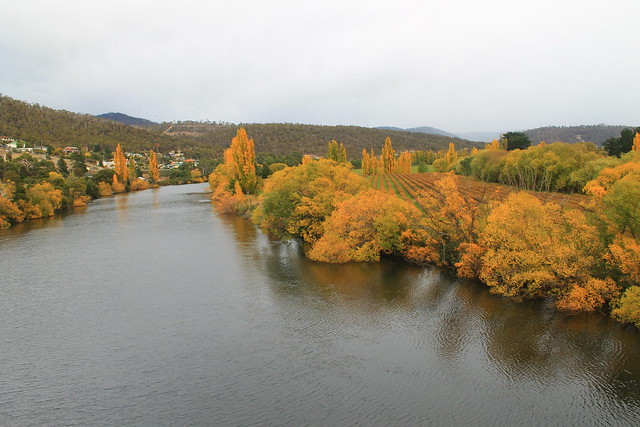
I needed a break. After four solid months of slogging through lab work, research, writing, reading, and teaching, I needed to step off the Sydney merry-go-round or go insane. Having moved to Glasgow in winter of 2012, then to Sydney in August, I pretty much had a year of winter immediately followed by the Australian summer with no change of seasons to speak of and definitely no Fall, which is my favourite. Sure I got a little taste of Michigan Football last September-November, but no pumpkin spiced lattes, no leaves changing colour, nothing. But the nice thing about Tasmania is that it is as far south from the Equator as Michigan and Vermont are north of it, and April in Tassie would be the same as October in the northern hemisphere. In other words, it was Fall!
Fall colours along the River Derwent in New Norfolk
I arrived in Hobart, Tasmania's capital, at 8am, picked up my rental car - a wee Suzuki Swift which I really ended up liking! - and started off down the Lyell Highway. My goal was to get to the small town of Strahan on the western coast of Tasmania, but I also wanted to see as much as possible. My initial plan was to drive north toward Launceston and then west to Cradle Mountain before arriving late in Strahan, but took the advice of locals on the r/tasmania subreddit who thought I might be better off taking the shorter route and actually experience it. They were right.
My first stop wasn't planned until Lake St. Clair in the Tasmanian central highlands, but after picking up coffee in New Norfolk - a town originally set up as a new homebase for Australian convicts stationed out at the soon to be abandoned Norfolk Island camp in the Tasman Sea - I crossed the River Derwent and had to stop because the trees along the riverbanks were on fire with autumnal colours! It was beautiful! From what I'd heard about Tasmania and the Tasmanian culture of environmental awareness and power of purchasing locally, I imagined it to be much like Vermont in the US. The similarities, I would find out, were uncanny, and the trees along the river were just the beginning. I do have to say, though, that this is the only time I've been happy seeing invasive species; you see, no native Australian trees change colour with the seasons, only the imported species from Europe and North America!
Continuing along through pastoral farming/grazing communities, the Lyell Hwy suddenly started its ascent into mountains and the roads became narrow, steep, and windy (and windy)! I passed some of Tasmania's many hydroelectric facilities in Terraleah and the road then spit me out onto the highland plateaus just east of the central Highlands.
Tasmania's central highlands and the entire southwest quadrant of the island are all preserved as National Parks, most of which make up the Tasmanian Wilderness World Heritage Area, and while you can access many places in those parks, the majority of it is left as a natural wilderness for your experienced outdoor exploration! The famed Overland Track is one of the World's best wilderness walks right through Cradle Mountain-Lake St. Clair National Park,and something I hope to do before leaving Australia.
My first planned stop, though, was at an artistic site just east of Lake St. Clair called The Wall in the Wilderness. I'd heard about this artist who is carving out scenes from Tasmania's varied industrial, cultural, and environmental histories in huge panels of wood. In my mind I imagined it to be like a huge detailed collage of various moments that I could learn a lot from. Surely I wouldn't be disappointed. But when I walked up to the door there was a big sign saying something along the lines of:
No cameras allowed! Personal photographs do not capture the essence of my artistic vision when taken in the wrong light. When I have people throwing punches at me for not allowing them to take photos it gives me the right ban all cameras. My art is self-funded and I will decide what I will and will not allow.
Well, that kind of made me stop in my tracks and think, "Wow, what an ass." But not knowing what this guy has gone through, I returned my camera to my car. I thought the $10 admission fee was a bit steep, especially with no student discounts, but I gave them the benefit of the doubt. The building was cold and dimly-lit and in the central hall was the Wall. It was impressive to look at. Dozens of wooden panels of Huon Pine were hanging from a central wall, the majority of which had images of Tassie history hand-carved into the wood: hydro power, convict history, the extinct Tasmanian tiger, and natural scenery - and those that weren't yet carved had the pencil marks on them showing what they would eventually be. It was neat, and the artist is obviously a talented wood-carver, but was it comparable to Michelangelo's painting of the Sistene Chapel (as the Wall's website claims)? No, not in the least bit! Maybe it was the sour taste left in my mouth from not being able to take my camera in, or the tone with which that message was conveyed, but I thought the wall was impressive in size only. There were no information placards describing what I was looking at, but I could buy a book for another $20 to learn about each panel. Essentially, I thought this piece of art was a waste of time and money and I do not encourage anyone to visit. You'll just be nickel-and-dimed out of $10 and with nothing given in return. It's not educational and not all that spectacular when all is said and done. And even though I paid to see the Wall - thus paying for the future work on the wall - I didn't even get to take a photo of it. Crap. Don't go.
Sitting on the ferry pier at Lake St. Clair
It was still cloudy out from morning rain showers, but I drove on to the entrance of Cradle Mountain-Lake St. Clair National Park at the southern end of Lake St. Clair, which fills a glacially carved basin and is Australia's deepest lake. I went to buy a pass from the Visitor Centre, hoping I could use it at all National Parks in Tasmania I'd go to over the next few days, but it turns out that the passes can't be transferred between cars and if you go to Cradle Mountain, you have to pay a separate, exorbitant, entrance fee - so I settled on the day-pass and went to inquire about the Lake's ferry service. Being on the south side of the park, This is the ending point for anyone doing the Overland Track and a ferry service operates between both ends of the lake taking OT walkers and day-hikers to various piers. Not having enough time to do a four-hour walk, I was just hoping to get into the wilderness via the ferry, but after inquiring about it, I found out I was 10 minutes late and that no more ferries were scheduled for the day (damn Wall in the Wilderness!). So I walked down to the lake's edge for a bit taking in the staggering mountain scenery that was constantly peeking in and out of low-hanging grey clouds. Even on a bleak afternoon it was beautiful.
Back in the car the clouds started clearing, changing to big puffy white clouds, and the sun came out! Not much further down the Lyell Hwy I started seeing huge mountain after huge mountain loom into view from road as it twisted between them and the geologist inside me took over and every time I saw something new I'd let out an, "Oh my Gaaaawwwwddd!!!!! Woooowwwwww!!!!" The National Parks of Tasmania really earn their status as being stunning and beautiful! With stops at the Great Divide and Happy Valley overlook, I parked down at the Franklin River Nature Walk.
The Franklin River rose to international recognition in the 1980s when environmentalists started protesting plans to dam the Franklin River downstream from here. It is one of Tasmania's last wilderness rivers and the environmentalists were fighting to keep it that way. The hydro company eventually lost the battle and a new era of environmentally-conscious Australians rose to national political prominence. Furthermore, a new importance was placed on wild areas of Tasmania with an effort to keep them wild and untouched as much as possible. The walk was short but goes right along the banks of the Franklin and Surprise Rivers and weaves between massive pine and gum trees - some of which are the tallest species of trees in the world!
I'm not sure what the Highway is like during peak holiday season, but the Lyell was essentially empty for my entire drive. The afternoon was getting on and I'd decided that I needed to get to Strahan before sunset so I could watch the sun go down over the Southern Ocean - which you can't really do from too many places in the world! In my rush, I almost missed one of the best views of Tasmania: Donaghy Wilderness Overlook. I actually drove past the parking lot, but turned around. Two backpackers from the UK were just finishing and when I asked if the 30-minute walk was worth it, they said, "We've been traveling around Australia for two months and this is by far the best overlook we've seen!" I was sold, parked my car, and started walking.
I was not disappointed. If you take it quickly, it only takes about 20 minutes and the walk takes you to a little knob from which you get a 360-degree view of the surrounding mountains, valleys, rivers, and the ever-impressive Frenchmans Cap - a unmistakably unique mountain crag off in the distance which can be seen from miles and miles around! There was no one else out on the overlook and I had the place to myself under warm blue skies and a sun just beginning to dip below the mountains to the west. I grabbed a bunch of photos and sped back to my car. I only had about 2 hours left before sundown and it was more than 2 hours to get to Strahan.
Sunset in western Tasmania taken from the shores of Lake Burbury
I sped down the road, probably faster than I should have been going, trying to make it to Ocean Beach in Strahan before the sun hit the horizon, but I kept coming across beautiful scenery! I next had to take a quick minute at Lake Burbury because the sun's rays were shining from behind the tips of the nearby mountain peaks, casting glorious rays over the land, and I am certain I got some of the best sunset photos I will ever take in my life! And then the drive into Queenstown - famous for its regional mining operations which have all but stripped the hillsides of any and all vegetation and sediment cover. The road coming down out of the mountains to Queenstown was also beautiful, but in an industrial and destructive way. At least Mt. Owen seemed to still be forested and one massive waterfall was cascading down the hillsides.
I got to Strahan with about 15 minutes to spare, drove around the town and out to Ocean Beach where I missed the sun actually setting, though the sky was still beautifully lit up with pinks, oranges, reds, and the blues of the night. I stepped out and down to the beach where I took my shoes and socks off, rolled up my jeans and walked down to the water's edge, finally allowing myself to breathe and take in the dusky views up and down the beach - Tasmania's longest. I picked up a few pebbles as keepsakes as the ocean waters washed over my feet because after all, it's not all that often you can say you've stuck your toes in the Southern Ocean. Tasmania and the southern tips of South Africa, Argentina, Chile, and New Zealand are really the only places you can do this (and Antarctica, too), and it's quite a surreal experience when you consider its vastness.
Happy with everything I was able to accomplish along the Lyell Highway, I drove back to Strahan in the dark, found my hostel - the Strahan Backpackers YHA - and got great advice from the owner for delicious fish 'n' chips, Schwoch's, in the town's centre. A delicious ending to a busy, productive, and beautiful day!
Back in January a group of friends and I took a day-trip south of Sydney to Wollongong, Morton National Park, and Kiama. I think we all just needed a day to get out of the city and wanted to see some cool sites along the way. Well, it was successful, I'd say. We left early in the day and drove the hour it took to get to Wollongong where we stopped along the coast to check out the lighthouse and the sea rocks before grabbing an early lunch at Le Vendi along the harbour which boasts Wollongong's best fish 'n' chips, which were good, but I'm beginning to think that a chippy is going to have to really step it up in order to get that title in my books. The rock platforms beneath the lighthouse were pretty impressive! Deep salt weathering pits, widened by wave action, were filled with water and all sorts of seaweeds, crabs, and little fish. Some were big enough to fit a few people into, like a wee jacuzzi! The waves were big too, and I soon learned I should have brought an extra pair of socks... Wollongong is a University town but also has quite a lot of industrial activity along the coast. Not sure if it's a place I'd prefer to live.
The double-cascades of Belmore Falls. Only a
trickle now, it's easy to imagine them in full force!
After lunch, we drove the Illawarra Highway west through Macquarie Pass National Park - which is one of the coolest windiest roads I've ever been on, rivaling those I took through Mangamuka Gorge on New Zealand's North Island - to the small town of Robertson for a photo-op with the Big Potato, and finally to our first waterfall destination: Belmore Falls. Belmore falls, and all the other nearby waterfalls, cascades from the highlands to the deep valleys below over spectacular sandstone cliffs of the Hawkesbury Sandstone. We stopped at a view point looking down to the Kangaroo River Valley before heading over to the waterfall where we hopped a few large pools of water to get as close as we could to the waterfall's edge, which was only possible because the waterfall was nothing more than a little trickle at this time of the year. As anyone would, we tried our luck throwing some small boulders into the pool at the base of the waterfall to see how big of a splash or sound we could get. Lucky for us, the splash was big, but the sound - a big CRACKING noise - was loud and echoed off the walls. Awesome!
Continuing on we stopped at Fitzroy Falls for a little nature walk and waterfall viewing and also at Carrington Falls in Budderoo National Park. Carrington Falls spilled down into a tall, vertical chute and my friend Paul and I thought it would be a hoot to throw a few rocks down into the chute, which was difficult because the closest viewing platform was still so far away that we only managed to get little rocks into the falls, but they still made a satisfying sound!
The bright blue ocean swells entering
Kiama's famous Blowhole
Back in the cars, we drove to Kiama and it's famous Blowhole! A blowhole starts out its life as a sea-cave, eroded into the rocks by wave action. Eventually, this cave tunnels its way into the rocks and the roof of the cave collapses so that now, when large ocean waves and swells are forced into the sea-tunnel, they speed up and slam into the back of the cave, erupting the water upwards. The Blowhole was really active when we were there and the water erupted a good 10 metres up into the air! We ventured down to the edge of the sea cliffs, and then I alone crept my way down to the rock platform near the mouth of the blowhole where I watched the huge ocean swells flow in and out of the Blowhole entrance. It was hypnotic and the bright turquoise blue water was just mesmerising! As the sun set, we headed up the street to a pork-roast dinner at the RSL (a kind of club for members of Australia's armed services and their families).
It was just a day trip, but we sure covered a lot of ground and I always think it's nice to get off the merry-go-round that can be city life!
After a hellishly adventurous morning of hiking, soaking wet, in the rain out to New Zealand's westernmost point, I wasn't sure how much more adventure I'd be up for for the rest of the day. But then, as I was driving from Cape Reinga to Paihia, where I had accommodation booked that night, I passed the sign for Te Paki Sand Dunes and thought to myself, "I might not ever get the chance to come back this way in my life, so I might as well stop and see it now."
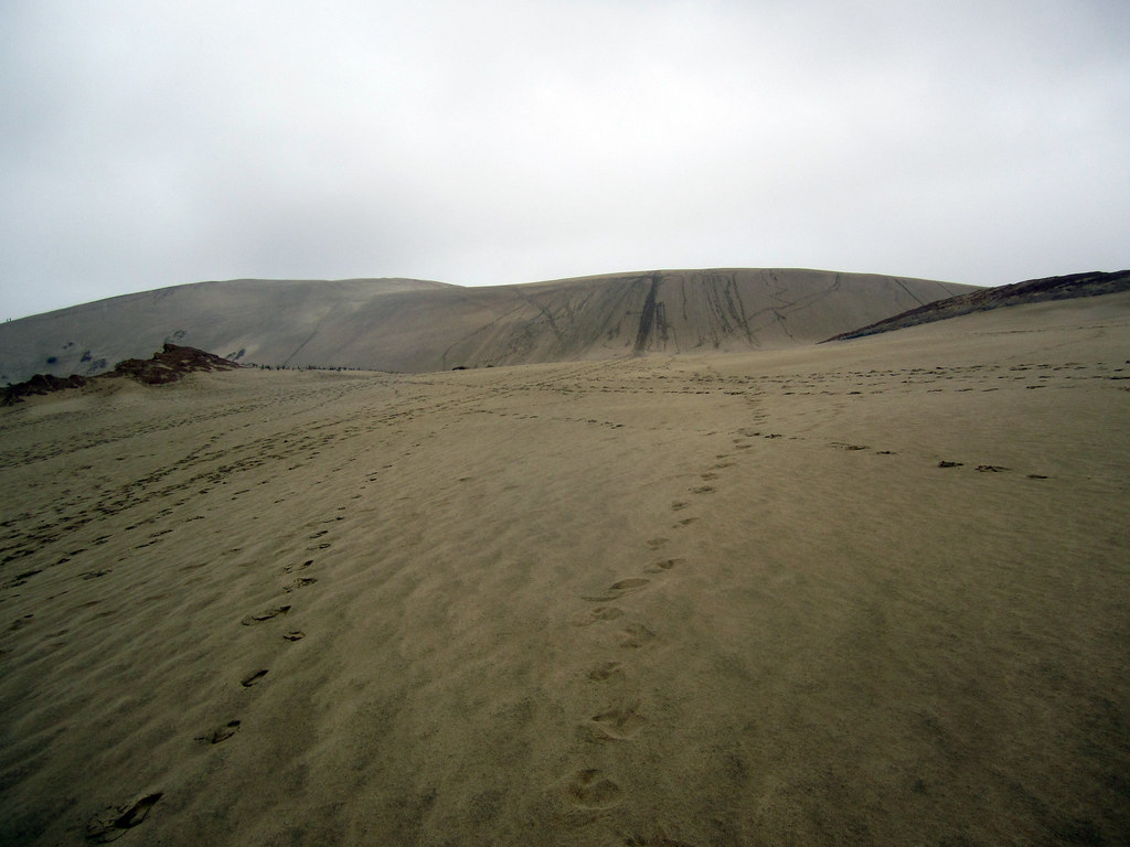
Coming over the first rise at Te Paki Sand Dunes
Good thing I did! Te Paki sand dunes are the highest dunes in New Zealand, and they are massive (though not as big as Sleeping Bear Dunes or Pictured Rocks). I parked my car and pulled out my rain gear, because it was still raining and I had had enough of being soaked to the bone, and crossed a shallow little stream to get to the base of the dunes. The blisters on my feet weren't enjoying being cramped up in shoes or sandals, even, so I went barefoot climbing the first steep ascent which opens up on top to a vast, wide, plateau of sand with a few rocky outcrops sticking out. On the other side of the plateau was another climb to what looked like the highest dune peak around and when I got to the top of that, I realised just how expansive the dune fields here are! According to Lonely Planet's New Zealand Guide, there are 7 square kilometres of dunes here offering all sorts of recreation activities like sand tobogganing (which you can rent from the little van in the parking lot) and the start (or end) of the famous 4WD off-roading expedition up/down 90 Mile Beach is also here.
Well, I knew I wasn't going to spend a huge amount of time here, so when I got to the top, I had a nice look around, took some photos of the area, and then starting heading down. But this wasn't just any saunter down the sandy slopes. Oh, no! Growing up going to the beaches, one of my favourite things to do was go dune jumping. Usually this involves finding a nice sturdy tussock of grass near the top of the dune, getting a running start, and then throwing yourself off that tussock into the air and landing on the downslope surface of the dune. If you land on your feet without breaking your legs, it's possible to then use that momentum and run all the way down the rest of the hill. There was no dune grass here, but the sand slope was steep and a good running start was all I needed and with arms windmilling through the air, I ran down in big, leaping steps to the sandy plateau.
Here on the plateau, one of the rock outcrops caught my interest. It was circular from above and looked almost dome-like except that while the middle of the dome and its edges were still in tact, the rest had eroded out by some means of chemical or physical weathering. Up on the dune slope I'd just run down, there were a few other people using their footsteps to make large pictures in the sand. I think the one group of kids must have been from Switzerland since they made a big square with the cross in the middle.
I crossed the sandy plateau and dune-jumped my way back down to the creek and crossed over to my car, brushed off and got back on the road. Not much further down the cape, there was a sign pointing toward "New Zealand's Northernmost Pub" and I thought I should stop in for a bite to eat and charge my phone at the same time. I figured it would be some British-esque pub with a warm fire, carved wood booths, and a generally cozy atmosphere. Boy was I wrong. This place I don't think ever was cozy or welcoming, and while the staff was friendly and accommodating, I didn't want to stay there a moment longer than I needed to and I don't suggest anyone stop here. You will be sorely disappointed!
The Whangaroa lookout
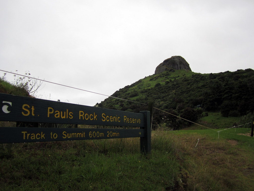
Finally, I was on the road again and kept driving for a few hours, listening to local Maori radio which had some good music on there, including a lot of Christian songs I remember singing in elementary school, but sung in Maori with a South Pacific twist. I'd read about another spot that I thought might be worth looking into. The hills in and around the town of Whangaroa (remember, in New Zealand, Wh- is pronounced F-) are generally forested except for their tops which are exposed, bare, rocky knobs made of conglomerates and granite - if I remember right! The hilltop in Whangaroa offers an awesome 360° vista of the entire area and the Whangaroa Bay right next to it. I found the parking area at the Saint Paul's Rock Scenic Reserve and started up the trail which was really slippery thanks to the mixture of mud and rain. To get to the top of the rock, though, the trail climbs up through the exposure and you need to hold on to chains fastened into the rock to pull yourself up to the top! It was a nice view indeed. Even in the gray late-afternoon you could see all the way out to the ocean, see all of Whangaroa Bay, and even an expansive oyster farm.
I didn't stay long, though, just long enough to get a 360° panoramic shot but then I got back in the car and kept driving. My destination for the night was the Aroha Island Ecological Centre, just east of Kerikeri. I'd read about Aroha Island in the Lonely Planet guide and after reading that they have a few northern brown kiwi birds living on the island, I didn't think I had a choice but to book a camping spot here! Kiwis are exceptionally rare in the wild in New Zealand. In fact, many New Zealanders haven't seen a kiwi in the wild! Since I've been on my "must see all Australian wildlife in the wild" kick, I figured I may as well add kiwis to the list and do my best to see them in their native habitat, too! And Aroha Island was the perfect place for that; they offered nightly tours of the island for an additional charge saying that most tours see a kiwi. But when I checked in, the lovely woman at the Welcome Centre said they weren't doing any tours...but that I could use one of their flashlights and have a map of the island and see if I could see them for myself!
I set up my tent in the last remaining hours of daylight and backed up all of my photos from my hiking adventures at Cape Reinga to my iPad, waiting for darkness to settle in. The woman told me that the kiwis are seen all hours of the night and that they start roaming around 10:30pm. I was told to not make much noise because while kiwis have bad eyesight, they hear very well; I was also told to use the flashlight given to me which had a red filter on it because the kiwis couldn't see that red light, and that any regular flashlight would scare them off for sure. It started raining again, though not too hard, and I figured I'd have to put my rain gear back on if I didn't want to get wet, but that meant I'd be making a lot of noise while walking along the path. The island isn't large and only take about 30 minutes to walk the perimeter, so I set off with the red light and the map.
The woman also mentioned that I would know the kiwis were there long before seeing them because they make a very distinct snuffling noise. Kiwis are different from most birds in that their nostrils are located at the end of their beaks and since they use their beaks to sift through the soil while looking for food, they constantly have to clear their airways and in doing so make a very dry wheezing sound. Well, even with that information, I couldn't hear much more than the rain dripping through the leaves and my rain pants brushing up against each other. I moved so slowly along the path, thinking every noise was a kiwi, that it took me about half an hour just to walk half the island. I started along the other half thinking I was on a wild goose - errr kiwi - chase when I heard it!
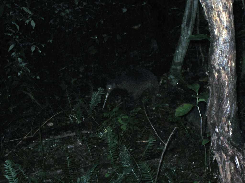
One of the two wild northern brown kiwis I saw on Aroha Island
Above the pitter-patter of the rain I thought I heard people talking and I thought it must be some other kiwi-scouts, but looking ahead, I didn't see any lights but kept hearing a dry, scraping, snuffle sound. I rounded the corner in the path, and sure enough, right in front of me, no more than 2 metres away were two adult kiwis! They were big! I mean big compared to what I imagined them. I always thought they were maybe the size of a grapefruit, but these were each the size of a rugby ball, stuck up on what looked like three spindly legs, but then I realised the third leg was just their beak! I didn't want to make too much noise but I wanted to get closer to see if I could get some photos of them with my phone. I'm not sure if it was the rain or if their hearing isn't as great as the woman told me, but I was able to sneak within a metre of them both without them realising, or caring, that I was there! I just stood there for about 20 minutes watching these amazing birds do their thing, rooting through the soil along the path looking for food, and they eventually moved off and started heading down the hill toward the water. I decided that if they were going to leave, I'd try getting a few photos of them with my flash on, and while they moved away after the first flash, they didn't seem to be terrified by it and stayed relatively close, so I took a few more before leaving them to eat in peace! I think my heart was pumping just as much as it had been that morning when I was trying not to be swept out to sea by incoming waves! Here, on tiny Aroha Island, was some young Yank who just wanted to see kiwis in the wild, and with very minimal effort was able to do what so few people have ever had the opportunity to do!
Needless to say, at the end of the day, hiking 15 kilometres, climbing a large sand dune, hiking to the top of a rocky lookout, and successfully sighting some wild kiwis, I was exhausted and slept very very well! The next morning, as I was packing up my tent, some very friendly ducks came by to wish me safe travels and to thank me for staying at Aroha Island, insisting that I recommend it to anyone who wants to have wild kiwi adventures while traveling through New Zealand. I told them I surely would!