Presently, I am sitting in front of my computer waiting for some data processing to finish in ArcGIS (a geospatial mapping software package) and going over edits to a paper manuscript I am getting ready to submit for publication. The paper is essentially Part II of my Masters Thesis which I finished this past January at the University of Vermont. My project was fairly simple in scope: determine the erosion rate for bedrock outcrops in the central Appalachian Mountains. Turns out they are slowly eroding away at only a few millimeters per thousand years, so don't worry - the ground will not just drop out from under your feet!
We use various chemical procedures to extract a form of the element, beryllium, from rocks and since the rocks we needed were in the Appalachian Mountains, someone had to go get them. This someone happened to be me!
Two summers ago (2009), my classmate, Charles, and I spent two weeks traipsing around the central Appalachians hiking up mountains and collecting rocks from the uppermost parts of rock outcrops. Charles was doing field work in that region as well, so we also spent time collecting sand from streams and rivers for his research.
We touched down at BWI with our advisor, got our rental car (a nice little Chevy Colbalt) and were off! The first place we went was to
Harpers Ferry National Historical Park at the confluence of the Potomac and Shenandoah Rivers. We hiked up to a small segment of the Appalachian Trail and got our first few samples (NOTE: I have documented permission from the NPS staff at Harpers Ferry to collect samples. In this and any other State and National Park, the removal of any material is prohibited and in many cases a federal offense!). My advisor showed me what kind of rock outcrops I wanted to sample, how some were better than others, and how to get the sample.
Harpers Ferry is a quaint little town with a storied history seeped in trade, bloody battles, and industry. Many American Civil War battles were fought here and some of the trenches dug out by the soldiers and battlements are still visible.
 |
| Civil War battlements on the Maryland Heights side of the Potomac at Harpers Ferry NHP. |
 |
| Civil War battlements preserved on the Loudoun Heights side of the Potomac at Harpers Ferry NHP. |
 |
| Civil War battle trenches preserved on the Loudoun Heights side of the Potomac at Harpers Ferry NHP |
Our advisor was only with us for a few days and so the next day we moved further north to Maryland. It was mid-May and Spring had come to the central Appalachians. Fortunately for us that meant the hiking would be beautiful! Unfortunately for me it meant learning the hard way that I have allergies... The first hike of that day was in Cunningham Falls State Park and it was a long, sunny walk through a dogwood forest. The trees had just begun to bloom and except for my constant sneezing, it was perfect.
 |
| Dogwoods in bloom in Cunningham Falls State Park, MD |
 |
| More pollen-producing sneeze machines |
The nice thing about this time of year was that the wildlife was also just starting to come alive. In Cunningham Falls SP, we came across many animals we would frequently run into during the two weeks following. But only here at our sampling site did we see a snake, sunning itself in the hollow of a tree!
 |
| Red spotted newt (it's about 2 inches long!) |
 |
| These millipedes were everywhere, all over the hiking trails |
 |
| The only snake we saw! |
With four new samples collected, we went up to
Catoctin Mountain Park, a unit of the National Park Service in Maryland. I had never really heard much about Catoctin before, other than Camp David - the Presidential Retreat - is nearby. I was pretty astounded with the size and grandeur of this small little Appalachian Park and though we only had a little bit of time there, I plan on going back and exploring more of it!
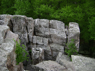 |
| Rock formations in Catoctin Mountain Park |
|
 |
| My classmate exploring the rocks at Catoctin |
My advisor had to get to his folks' house that evening in Baltimare, so Charles and I drove him back to the city and then we parked downtown and got a delicious seafood dinner at
Eat Bertha's Mussels in Baltimore's back-bay. I was still in my picky-eating phase, so I stuck with fish 'n' chips while Charles opted to go for the restaurant's namesake - mussels. Charles and I spent the next few days collecting rocks again at Harpers Ferry NHP as well as in South Mountain State Park in Maryland.
 |
| Taking notes at a sampling site at Ravens Rock in South Mtn. SP |
Then it was Charles's turn. We had an agreement that while I was collecting samples, I would navigate to the next sample site and he would drive and then our roles would be reversed when he was collecting samples. So the next few days I spent driving around the greater Washington DC area. While most of his sampling sites were out in the countryside, a good few of them were in suburban neighborhoods where we had to suspiciously cross private property to gain access to a creek to collect the sediment. Another good few of them were very near government properties like...Andrews Air Force Base or the Department of Agriculture's Research Facilities.
I'll be honest: I was nervous. We would leave our rental car at the end of some cul-de-sac, put on our muck boots, and go tromping through forested plots of land where I could all but help think about the number of dead bodies that may or may not have been dumped after unfortunate mob encounters or something fantastical like that. I became increasingly aware of Big Brother's presence everywhere around Washington DC. This feeling was most heightened around Andrews AFB (where Air Force 1 lives) and I could actually see the thin barbed-wire boundary just strung between trees with little tags that read, "WARNING: Government Property! Do not cross!" But this boundary was not always marked and my worst fear was that we would unknowingly step onto government property, be detained, and have to explain ourselves to intimidating officials, who wouldn't buy our "we're-grad-students-doing-research" story, and ship us down to Guantanamo Bay where we would be water-boarded and forced to bunk up with real terrorists. Luckily, my worst fears were unfounded and sampling in DC was complete without a hitch.
We left the DC area for the sandy flat-lands south of the City on the peninsula between the Potomac River and Chesapeake Bay. I could tell from driving around that this area was very seldom traveled by tourists but I was amazed at how beautiful the landscape was - and we were just a few hours from the city! It was mostly flat and sandy with towering shady pine trees. If I didn't know any better, I would have thought I was up in the woods near my family's cabin in northern Michigan!
Another day was spent crossing back over to the Alexandria side of Washington DC where we collected more stream sediment and tried collecting some more rock samples for my research, but nature thwarted us again, and in fear of being gassed out, we drove on.
 |
| Stupid gypsy moths...ruining my research! |