Saturday, September 22, 2012

Sydney: Observatory Hill and the Botanical Gardens

Last weekend's weather was great, so I took advantage of it. After the previous day's long walk from Bondi Beach to Maroubra Beach, I decided to do something a wee bit less taxing. The sun was out and I decided I'd just go downtown, buy the Lonely Planet guidebook for Australia and sit in the Botanical Gardens reading it with my camera nearby in case I happened to come across some neat wildlife (the flying foxes are starting to come out again, so I'm determined to get some photos of them!).

What happened instead is that I bought my book, but once I got down to Circular Quay decided to head up into The Rocks to find a little licorice stand that sells all flavors of licorice and wander. With my licorice in hand, I ended up walking under the Sydney Harbour Bridge to the quieter side of The Rocks. Here, the neighborhoods are quaint and you can imagine what it was like as Australia's first European settlement.

One of the things I never really realized was that part of Captain James Cook's voyage to the Southern Lands was to observe the transit of Venus across the sun - the transit is kind of like an eclipse where Venus passes directly between Earth and the sun. Measuring it's transit allowed scientists in the 1700s to better determine just how far away from the sun Earth is. Come to think of it, what a terrifying world the people of that time must have lived in, generally not knowing if the Earth was moving closer to the sun each year, or what. So in 1784 Captain Cook arrived in Tahiti to measure just that and on that voyage, Australia was settled. The special thing about the transits of Venus is that they occur twice, separated by eight years, and then do not reoccur for another 100 years. So when the time is right, careful measurements must be made or risk waiting a century before trying again.

Once Sydney was settled, one of the first tasks was to construct the Sydney Observatory. Now, I always just thought that observatories were for looking at stars and planets and into space, but I didn't realize how much importance they had for everyday commerce. For example, it would have been impossible for merchants, sailors, and governmental institutions to keep the correct time without the observatory. Every day at 1:00pm, a time ball on the spire on top of the observatory was raised and it began a slow descent over the course of the day - much in the same way, but much less glitzy, the ball drops in Times Square marking the start of a new year in New York City. The time ball was operated at the observatory because measurements of time were based off of the movement of stars and were taken by the astronomers at the observatory.
16SEP2012 (6)
Back side of the Observatory with the Time Ball seen on the top tower

Another neat feature outside the observatory is the Flagstaff which was a means of communication between the city observatory and the signal station at the south head of the harbor. Different flags indicated the different names of ships entering the harbor, where the ships were coming from, and what was their cargo. Other signal stations around the harbor also sent messages to ships on the water and those leaving the harbor of weather conditions and other information.
16SEP2012 (7)
Flagstaff and Signal Keeper's Quarters

Inside the observatory is like stepping back in time, yet also into the future. Numerous nautical instruments are on display, log books, telescopes, models of the solar system, and information panels about the advancement of observatory technologies today. It is all free and a fascinating place to wander around. Another one of the really interesting things I learned there is that while at sea, it is easy to determine one's position North or South; however, it is much more difficult to determine your longitudinal position - East or West. This was especially tricky for the first explorers who set out to map the Australian coastline; however, it was completed successfully and some of the material from that expedition is on display at the Observatory.

Thoroughly impressed by the quiet piece of greenery on the west side of the Rocks, I made my way back down to the city and over to the Botanical Gardens. I still had maybe an hour of daylight and thought it would be a nice time to take some photos of the Opera House and the Harbour Bridge (I really won't ever tire of doing that!). After getting some good shots, I thought at least, I started to head back home through the Gardens and was lucky enough to catch some of the birds who live in the Gardens including a kookaburra (which I personally really enjoyed), cockatoos eating nuts, an ibis, and some dusky moorhens.
16SEP2012 (31)
Kookaburra

Friday, September 21, 2012

Sydney: Coastal Walk between Bondi and Maroubra Beach

Walking Date: 15 September 2012

Two weekends ago, I started off a little project when I walked from the south head of Sydney Harbour to Bondi Beach. Last weekend I continued that project by starting at Bondi Beach and following the coastal route down to Maroubra Beach. Originally, I was just going to go to Coogee Beach, along the way, but since I'd done that bit of the walk last year when I was here, so I decided to continue past Coogee and end up down in Maroubra.

The walk is beautiful any time of year, but it's best done with sun and a bit of warmth. I had the sun last week, which helped, but it was a bit breezy and though I brought jeans with me, I never put them on. Bondi Beach was great. Not as crowded as the week before, but there were still plenty of surfers, and the Icebergs Swim Club's tidal pool had a few swimmers braving the waves to get a few laps in. With nice weather in Sydney comes weddings and along the coast is no exception. Right off the bat, I passed a small wedding right up on top of the rocks, and being a windy day there were plenty of people flying kites as well.
15SEP2012 (5)
Bondi Beach

I didn't get too far but was hungry already. Luckily, the next cove south of Bondi Beach is a little inlet called Tamarama Beach were I stopped for a chocolate shake and chicken burger at the little Tamarama Beach Cafe and watched a surfer catch a few waves, which is just mind boggling because there are rocks everywhere along the beach and when I say that Tamarama Beach is just a little inlet, I mean it is narrow. How that surfer survived, I'm not sure! If I were to try my hand at surfing, I would definitely go somewhere like Bondi or Bronte Beaches where the water is just wider. In fact, at Bronte Beach, the next beach along my walk, the first Surf Life Saving Club in Australia was established train and build up a force of people poised to help surfers and swimmers at risk out in the cold waters of the Pacific.
15SEP2012 (27)
Tamarama Surf Life Saving Club

Just past Bronte Beach is one of the most beautiful cemeteries I've ever seen. The Waverley Cemetery is perched right on top of the sandstone cliffs and extends right to their edge. Recently, a modern boardwalk was built between the cemetery and the ocean, which also protects native hanging swamps along the cliffs which are home to a few species of frogs which you can hear chirping in the water-soaked pools.

Continuing along the path is Burrows Park, where you can watch lawn bowling or rugby (or Australian football...I'm not sure what type of field I was looking at, actually) and can stroll right out to the flat sandstone and watch the waves crash below your feet. Then the path leads you around the extremely narrow Clovelly Cove which is built up with concrete on either side of the inlet and since rocks off the coast extend across the mouth of the cove, it's actually fairly protected from heavy ocean waves and many people were swimming laps in the inlet. Following Clovelly is a wider cove where concrete pillars have been sunk under water and connected with chains so divers, and snorkelers on clear days, can follow an underwater path and see some of the coastal wildlife.

Just before Coogee Beach is a very nice sculpture dedicated in memory to the Australian lives lost in the 2002 terrorist bombings in Bali. The three rings represent Family, Friends, and Community and are all intertwined. Next to the memorial is another one of the many seaside baths, protected by man-made or natural barriers from the pounding ocean waves. But then you're in Coogee, a wide, sandy, less-crowded but nonetheless stunning surfing beach.
15SEP2012 (39)
Bali Memorial

I thought about stopping and finishing the walk to Maroubra Beach another day, but I still had a few hours of daylight left and decided to go for it. The walk continues through parks and along another long boardwalk built over native wetlands where I stopped for a few moments to take some photos of a heron who was feeding in the shallow pools.

Not long thereafter the coastal walk dumps you out in a suburb and I almost lost the trail, but a nice local gave me directions which led me down a very narrow and steep stairway between very nice houses. The local told me that I should have no problem walking along the rocks since it wasn't too windy, so I put my trust in him and carried on. For the next stretch of the walk, I had to make my own way over the rocks right along the coast where the waves, saltwater, and animals have created stunning weathering patterns in the rock.
15SEP2012 (71)
Weathering patterns on the coastal rocks

After one more walk through a park on one of the coastal headlands, my path turned me toward Maroubra Beach right at sunset and I stumbled over the rocks, through a small crowd of fishermen, and out onto the beach which was wide, wind-swept, and empty! There isn't much to the little beach front part of Maroubra itself, but I did congratulate myself with a schooner of beer at the Maroubra Hotel and caught a bus home.

Sunday, September 9, 2012

Australia: Terrigal and Killcare

Travel date: 01 September 2012

I wanted to do just a quick post before I forget about these photos. But last weekend I took the train up to Gosford to visit one of my friends who is leaving for a research stint in Antarctica in the next few weeks. Gosford is not really near Sydney and it takes about an hour and twenty minutes on the train, but it is a beautiful train ride that veers off from the highlands above the flooded estuaries of the Hawkesbury River, rumbles through a few tunnels, and then snakes along the shoreline right on the waters edge through the Brisbane Waters National Park. It was too sunny of a day and the trains windows were dirty, so I didn't get any photos of the journey, but it is amazingly stunning and you're pinched between steep, forested hills and expanses of water that kind of just tuck in and out of the hillsides.

I was picked up at the airport by my friend in her car and we drove out to Terrigal which is right on the Pacific and still maintains some of it's quaint small-town charm, though it's marred by some fancy hotels and resort traffic. At first we just drove through, and kept driving through Bouddi National Park to the tiny tiny town of Killcare. This area reminded me a lot of Michigan and the numerous small towns nestled in the dunes of Lake Michigan with roads going up and down hills and winding around lakes or inlets, eventually opening up to beautiful views of sparkling blue waters.
01SEP2012 (3)
Not sure what kind of bird this is. But they are also all over the place, looking for table scraps!


01SEP2012 (4)
Rosellas are a bit more demonic looking than their plumage makes them seem. They are rude scavengers who aren't afraid to bite you if you have food in your fingers!

Killcare is a snoozy little town. I mean, not much goes on there, and it pretty much consists of a few little cafes (our food from l'Anxaneta was delicious and filling and I thought we definitely got what we paid for!). L'Anxaneta is a cute, brightly colored cafe across the one-lane road from the quiet Hardy's Bay and it's filled with Picasso-inspired paintings. My friend and I chatted over burgers while watching the waitresses shoo away the rosellas who are not afraid of people and want to eat your food!

Afterward, we drove back through the National Park and back to Terrigal where we got out of the car to walk around a little bit - took a stroll down by the beach (it's one of those long, wind-swept beaches surrounded by promontories, except the ones here are not covered in houses like the ones in Sydney!) and onto some rocks and then headed back to Gosford. It was a great day for a little bit of a day trip. I'm beginning to like this idea of so many rural and quiet places so close and within reach of the big Sydney city!
01SEP2012 (5)
Terrigal Beach is much less crowded than any of the city beaches I've been to and so much bigger, too!!

01SEP2012 (7)
The waterfront at Terrigal Beach is just more relaxed and quiet - only small fishing and recreational boats and not the armada of sailboats packed away in Sydney Harbour!

Saturday, September 8, 2012

Sydney Coastal Walk 1: Sydney Harbour National Park to Bondi Beach

Yesterday was one of those days that I just decided I needed something to do. I've been going to the gym lately, and my arms were very very sore, so I decided that I need to do something active that wasn't in a weight-room. It was sunny and I decided to go for a walk. So I put on my U of M football t-shirt (it was Saturday, afterall!), strapped my shoes on, and headed down to the ferry docks at Circular Quay. Circular Quay is the main port in Sydney and all of the various ferries that go out to Manly, the Toronga Zoo, and all the other Sydney suburbs on the water.

I decided that since Sydney is famous for it's coastline, I should spend some time along it. So I took the small catamaran ferry out to Watsons Bay, a small suburb right near the tip of the South Head of Sydney Harbour. From there, I walked north into one of the portions of Sydney Harbour National Park. This little piece of protected land is right at the tip of the South Head and is home to high sandstone cliffs and a few beaches on the harbour side. The South Head has been a military base since 1788 and oddly enough, was built up initially to protect Sydney from the threat of invading navies which wavered back and forth between France and America, depending on who Great Britain felt more threatened by at the time! The point was fortified in the early 1800s with cannons and battlements yet missed the arrival of six American ships in 1839. The point's battlements were built up even more during the two World Wars...but again missed the arrival of three Japanese submarines into the harbour. Since WWII, the very tip of the South Head has been put under protection of the National Park Service.

08SEP2012 (11)
Cannon battlement at Sydney Harbour National Park

One of the Park's main features is a fairly stubby lighthouse called the Hornby Light. It was built in response to the wrecking of the Dunbar, which ran aground in 1857, killing all but one passenger who eventually became the station master of the Hornby Light. The lighthouse wasn't completed in time, however, and another ship, the Catherine Adamson, met its fate near the harbour mouth, also in 1857.

08SEP2012 (18)
The Hornby Light Station

Protected in the park are still the light keeper's quarters, though you can't go in, and one of the big cannons positioned at the head. It's a nice little place to wander and enjoy the day. You'll see people laying out on the grass, or nudes swimming in the harbour, or firsherman down on the rocky shoreline at low tide. Nice little slice of peace in a big city!

I left the National Park and started walking south toward Bondi Beach, along the way passing through Gap Park which was originally Aboriginal land until Australian settlers pushed them out. By 1909 a tramline from the city was extended to Gap Park so Sydney-siders could enjoy a day trip out to the coastal cliffs. The tram is unfortunately dismantled now, but surely it would be a great little ride!

Further along the coast, I walked through a number of other parks and reserves, all with the path near the edge of the cliffs, but separated by a fence with frequent postings urging potential jumpers to consider their options. But the parks are nice with tons of people walking their dogs, biking with their kids, and just enjoying being outside. While the path is well defined for much of the walk, there are a number of sections where I had to walk inland, along a road, without very good views. But the weather was nice and I didn't mind looking at the beautiful houses and gardens along the road. Next was the Diamond Bay Reserve to Dover Heights Reserve portion of the walk where I saw a few guys fishing from cliffs at least 70 feet up from the ocean below. I'm not sure how much they catch each day, but I did see him pull in a little silvery-blue fish that couldn't have been bigger than his hand!

I had to veer inland for a few blocks and walked through the Dudley Page Reserve which provides spectacular views of the Sydney skyline and the harbour, sparkling blue, glinting sunlight off the little waves. There were tons of sailboats of every size out yesterday, enjoying the breezy warmth of the harbour. But onwards I went, back out to the cliffs edge at the Rodney Reserve. It's now nothing but a rugby pitch, but in the 1950s and '60s it was home to one of the world's most premiere radio telescopes, and it was here that astronomers built a 25-meter wide dish shaped depression on top of the cliffs and much of what we know today about space and radio waves was learned here.

Continuing south to Bondi, there aren't really any other parks you can walk through. But it's confusing if you ever try because there is still a lot of green space. It's a big golf course, but there is a sign outside that says Wilsons Park which made me think I could just go in and have a wander. Well, I did wander over to a big stack that looks like a monument of sorts, but I'm pretty sure its origin is fairly industrial. I didn't see many other people wandering around and after almost getting hit by a golf ball, I left pretty quickly.

I followed the road around one more jog and then ran into some backpackers heading down to the famous Bondi Beach. The beach is beautiful. It's a wide, wind-swept inlet off the ocean with large breaking waves perfect for catching a wave. It's a hot-spot for tourists, backpackers, and students and everyone seemed to be enjoying the relaxing lifestyle. I took my shoes off for a bit and walked through the water to the Bondi Pavilion and sat watching surfers for a while before heading up to the shops to get a late lunch which consisted of a massive helping of delicious fish and chips from the Bondi Surf Seafoods shop along the main drag. The sun was setting so I had one last wee walk along the beach to take some more photos of the surfers, but soon caught a bus back to the city and headed home.

It was a nice day in the sun and fresh air - one that I hope to have more of here in this beautiful corner of Earth!

Thursday, August 30, 2012

Sydney: A City Best Seen from the Water

It's been five weeks to the day since I first arrived in Sydney and I've only posted one blog post and it didn't even have photos. I am a lousy tour guide! Well, part of the reason is that I just haven't felt like I've done a whole lot. Sure I've seen things, but Australia is much different than Scotland in that there just aren't the centuries of tangible history that is so evident in Scotland. It's not to say that Australia doesn't have its own unique history, it's just a different kind of history.

My first week in Australia, after getting acclimated to the chilly winter was spent at Macquarie University, where I am now studying, planning my first excursion out into the region of New South Wales that is my research area. I am here to study a bunch of sediment that has caused quite a stir. The sediment has been deposited over the last few centuries, but when it actually started to be eroded from its original undisturbed sites and why or how are not well understood. That's where I come in. I'll sort all of that out in the long run, but after reading about this sediment for five months while in Glasgow, it was about time I actually went out to see some of it!

We were in the field for a week, and pretty much just driving around visiting different rivers and looking for the type of sediment we are interested in. We would drive to two or three potential sampling sites each day, and with breakfast and lunch in there, we somehow always managed to fill the day with things to do. Often, though, we would also get stopped by the scenery, or wildlife (kangaroos and a real live echidna!), or other roadside oddities. Lots of time was spent on farms, or in rural areas, looking at creeks. The Australian landscape, even where vegetated, is harsh and demanding. Much of the region surrounding Sydney was deforested for sheep and cattle grazing, but even that was beautiful in its own way. Of course, paddocks can't compete with the natural landscape, and I got my fill of both, driving through a few National Parks along the way.

05AUG2012 (1)
TONS of kangaroos near Canberra
One really cool experience I had in the field was getting stuck in a snow storm! Most Australians have told me you never see snow in Australia (though I swear I saw some downtown a few weeks ago - not many flakes, but definitely snow!). Anyway, we were driving through Namadji National Park in the southern end of the Australian Capitol Territory and the weather and scenery were beautiful! On the other side of the mountains, however, it started getting blustery and as we drove into the small town of Adaminaby, there were big, puffy, flakes of snow blowing around! It was such an experience that even the woman who owned the cafe we were eating at ran outside with her camera saying that she had never seen anything like it in her life before! Well, from Adaminaby to Cooma and almost all the way back to Queanbeyan, where we were staying, we had to drive carefully and slow to a creep just to get through some parts of it! An awesome experience that extremely few Aussies have had the chance to see! 

08AUG2012 (3)
Driving into the snowstorm
Here are some more photos from the field:


Once we got back from the field, I realized I needed to put a budget together for my research over the next year and a half (something I'm still working on!). It's a tedious process, and right now, while I'm still settling down, there's not much else I've really been able to do around the city, and since I don't know too many people yet, it's been a slow-going process checking things out. Over the last few weeks, I decided that while I like the apartment I am in right now and my flatmate, I really longed to be somewhere near a park, the water, or some semblance of nature. Sorry Parramatta Road, just not cutting it. Also, I'd love to be closer to a train line or one of the ferry terminals. Somewhere that is just easier to move around. So in looking for other apartments, I've seen a fair bit of the city.

The nice thing, though, was that last week, one of my best friends from high school was back in Sydney! Arianne moved to Australia last September though hadn't been living in Sydney, but last week our paths crossed and we spend a lot of our free time checking out different neighborhoods. We had drinks and Indian food in Newtown, shopped at the Glebe Market on a Saturday morning, took the ferry out to Manly Beach, spent an afternoon in the Botanical Gardens, and had a few schooners (rather than pints) at the Fortune of War, Sydney's oldest pub. It was so much fun seeing a face from home.

I think sometimes when you have these big life-changing moves around the world, you almost wonder if the rest of your life leading up to this moment actually happened. Sure, I talk to my friends and family frequently, but you get this nagging suspicion that it's all part of some larger conspiracy theory against you, making you think none of it is real. But then you get the chance to go home and see that everything is, in fact, still there. I haven't had the chance to go home, and probably won't while I'm here, but seeing Arianne really lifted my spirits and somehow I knew things down here would turn out all right.

I'll leave a bunch of photos here, and I've put captions with them to give you an idea of what they are, but there's no real story to them yet. Nice scenery, though, if I can say so.

Sunday, August 19, 2012

Sydney: I've moved to a land Down Under

It's about time I update this thing.

A little over three weeks have passed since I moved to Sydney at the end of July. I visited Sydney and some of the surrounding areas last year for a few weeks and had a blast. The weather was warm and sunny, the people were friendly, and I got to do a lot. Australia is one of those weird places in the world, though, that most people from the US just don't understand...at all. We are fed these images of a sunny, tropical, sandy, sometimes dry land with tall, blonde, cheery, extremely fit citizens who go around chasing kangaroos and surf all day. We think of people like Nicole Kidman and Hugh Jackman and think, "What a cool country!" And it is, for the most part. I think Australia is a prime example of a location being completely different when you're visiting than it is when you live there.

Now, to be fair, my preparation for the move to Australia was biased from the beginning when it took Macquarie University four months longer to get me registered as a student and situated with a valid student offer to get my visa than it should have. The upside was that I got to spend four extra and amazing months with wonderful officemates who all became close friends in Glasgow. But the registration process at Macquarie really put a damper on my spirits. But then the paperwork went through and I bought my tickets and things began to brighten up as I started the journey Down Under.

I had to stop at home, in Michigan, first for my brother and new awesome sister-in-law's wedding. The Monday after the wedding my dad drove me to Chicago Midway airport and I felt fine and was excited to finally be making this journey. I was upgraded to first class on my flights from Chicago to Minneapolis and Minneapolis to Los Angeles which is always excellent, but on the flight to Los Angeles, I started feeling achy, my stomach was upset, and I could feel my tonsils swelling up. By the time my flight was due to leave Los Angeles for the 14 hour ride across the Pacific and down to the Southern Hemisphere, tonsillitis was full-blown; I felt awful and it it hurt like hell every time I tried to swallow. I was looking forward so much to that flight because it's kind of an enjoyable time to veg out, read a good book, watch a movie or two, and if you're lucky, you'll have attractive flight attendants. I was flying Virgin Australia, and the entire crew was gorgeous, though of course, I didn't bat an eye as the nice ladies passed my seat. It was Mr. Flight Attendant who kept asking if I wanted a refill on my water that caught my attention. But it wasn't to be, of course, because thanks to my swollen tonsils, I was miserable, couldn't speak normally, and didn't have it in me to take advantage of the free drinks on the flight to give me a little liquid flirting courage (which I feel comfortable enough to say would have been welcomed by him!).

Oh well. I watched a few movies but pretty much just slept the entire time, wanting so bad to just touch down in Sydney. But for some reason, luck was just not on my side during this journey. About an hour out of Sydney the captain announced that we were going to try and land but that the airport was covered by an unusually thick fog. For most airports, fog isn't an issue. But Sydney's airport is not equipped with the proper tools to guide planes to the runway with no visibility. The airport was only landing about one out of six airplanes and the rest were being diverted to Brisbane, an hour north. Our plane descended, but right at the last minute, the pilot pulled the plane up and announced we were Brisbane-bound. My heart sank because all I wanted were some damn antibiotics. I knew as soon as I'd get them, I'd feel better in an instant (at least that what happens each time I get tonsillitis).

The weather was clear in Brisbane and landing wasn't a problem, but then we taxied behind all of the other diverted planes and sat on the tarmac for another hour. It was long enough that the plane ran out of water (but not before I got a small bottle and a number of salt sachets which I used to gargle and try to loosen some of phlegm from my swollen tonsils), had no food, and the pilots even went through the cabins speaking personally to each row of passengers. They explained that what happened in Sydney is so incredibly rare that in their 20-some years of flying into the airport, they'd only been diverted due to fog three or four times!

After an hour and a half of sitting on the tarmac, we taxied up to an empty jet bridge and were directed to disembark the plane with all of our belongings because we would be going through Australian customs here and be re-booked on other flights into Sydney now that the weather had cleared. It was here in Brisbane, on the ground, that I was finally able to get in touch with my advisor from Macquarie, who was supposed to pick me up from Sydney Airport at 7:30am (it was now 9:30am!). He told me to just take a taxi out to the University from the airport when I did arrive. Customs was fairly easy-going, even though there were some inconsistencies with my middle name on my passport and visa, but they let me through anyway with a friendly wave. It was amazing! In the US, I'd've been pulled aside and questioned like a terror-suspect, likely after a full strip search. But I got my bags, and I proceeded to the domestic check-in desk where I was, after again waiting for an hour or so, booked on a small flight into Sydney, which was now taking planes after the fog burned off within an our after our attempted landing (which only meant we could have circled Sydney for an hour instead of flying to Brisbane and been on the ground, at our intended arrival airport, at least four hours earlier!).

My advisor suggested I didn't need to come all the way out to the University which was a 40 minute drive from the airport, but there were still a few hours left in the day and I felt it was important not to waste them and to meet my advisor for the first time in person as well as my co-advisor who I hadn't spoken to or heard from ever before. I got there and everything was fine, except for the fact that I still was suffering from the end of day two of untreated tonsillitis. I was given a cab fare to get to my apartment, in the Camperdown suburb of Sydney, and I arrived in the early evening, meeting my apartment-mate, who was so generous and welcoming, even holding the room over for a few weeks and covering my portion of the security deposit (or bond, here in Australia) just so I could have a place to call home right from the get-go. We chatted a bit, got to know each other some, but then I had to clean up, take a shower, and get some rest.

I unrolled my sleeping bag and inflated my Therma-rest camping pad, because my room wasn't (still isn't) furnished and went to bed. The next morning came very early, and I was up around 3am, but the first thought that went through my head was, "DAMN! It's COLD!!!" Yes, that's right. Sydney is absolutely FREEZING in the winter time - which it is down here in the Southern Hemisphere while the rest of the people I knew were enjoying the warmth of summer. It's not so much the temperature that makes Sydney cold, but none of the houses or building have heaters installed nor do they have insulation. It's like every winter people here think that maybe, just maybe, it will be the last cold winter and that next year the temperature won't drop below freezing at night. They're never right, and because of that, I am so thankful I had enough room in my luggage to pack my sleeping bag which keeps me warm down to 0°F (-18°C), and I am so thankful that my family got me a Therma-Rest before I left for UM's Field Camp way back in 2007! Even though it's only an inch thick, this mattress pad is comfortable and warm, and without it, I am sure my apartment-mate would have found me frozen to the floor the next morning!

The day of my arrival, at the University, I was informed of a mandatory campus-wide introduction for new incoming post-graduate student. It was supposed to be six hour long and from what I gathered would be pretty pointless, though according to those speaking at it, full of information every student must know. Well, this convocation coincided with the only time of the day the Higher Degree Research office was going to be open, and I had to stop there to pick up my healthcare card, which thankfully had been set up before I arrived in Australia. Since I value my personal health over almost everything else, I told the nice office ladies, "Tough shit. I'm skipping that meeting and getting healthy!" (In nicer, more diplomatic words, of course.) With my healthcare card in hand, I oh-too-early sought out the campus's General Practitioner's office at the hospital where the diagnosis was, yup: tonsillitis. And then I successfully predicted the doctor's prescription: penicillin - four capsules a day until the prescription runs out. With two pills down by the end of the day, I woke up the next morning feeling rejuvenated and 100% better! But what a crappy way to start out transition to a new life in Australia.

There's more to tell from these first few weeks, but I have to leave it there at the moment. But I'll give you a little preview: Shock-and-awe at the cost of living, freezing cold nights, field work in the Tablelands, freezing cold nights, finally meeting some people in my department, freezing cold nights, exploring the city's suburbs, freezing cold nights, coping with being so far away from everything familiar, and oh yeah, freezing cold nights.

Monday, July 9, 2012

Scotland: Pollock Country Park II

Well, this is moving week for me, and before I go home to Michigan for a few days, I had a few things to take care of. In doing so, I had to make a trip to the Pollok Country Park once more. The park was voted Europe's Best Park in 2008 and today I took advantage of some nice weather to walk around the wooded park after doing my errands. It really is a beautiful park with miles of walking paths, bike paths, fields where highland cattle graze, woods, ponds, lakes, rivers, the Burrell Collection, and the Pollok House. You could spend an entire day there and if you're in Glasgow for any extended period of time, it's totally worth the visit (and super easy with the train from Glasgow Central).

08JUL2012 (1)


08JUL2012 (6)


08JUL2012 (10)


08JUL2012 (11)


08JUL2012 (12)


08JUL2012 (13)


08JUL2012 (15)


08JUL2012 (16)


08JUL2012 (19)


08JUL2012 (24)

Sunday, July 8, 2012

Scotland: Stirling Castle and William Wallace Memorial

Trip Date: 07 July 2012

This was my last weekend in Scotland until 2014. The time really flies by quickly! My friends and I decided to get out of town on Saturday and do something special and Scottish. Our original plans to go to the Highland Games near Loch Lomond fell through when the event was cancelled due to inclement weather and while Friday kind of rolled on by, we decided that rain or shine we would get out of town no matter what. Saturday arrived and was indeed raining. It wasn't a pouring rain, but it was more than a drizzle and pretty much constant throughout the day. Clearly, any outdoor activity was not going to be pleasant, so we drove an hour northeast of Glasgow to Stirling - the gateway to the highlands.

The Castle is situated on top of a tall ridge sitting high up over the surrounding valley. While most of the castle was built since the 1700s, a fortress or castle occupied the site for hundreds of years before. I am definitely not a historian, and cannot even attempt to get any of the factual details down here, so just understand that the castle switched occupation between the kings of Scotland and the kings of England for centuries. Famous battles within sight of the castle throughout the centuries saw victories for the Scottish heroes, William Wallace and Robert the Bruce, and was home to numerous Kings James and Kings Edwards of Scotland and even Mary Queen of Scots was born here and later lived here with her son. The castle was the home of the Scottish Crown until the early 1600s when King James inherited the English Crown and moved the Royal Court down to London. Since then, additions to the castle were less defensive and more inhabitable and has even been used as recently as the mid 1900s as it was the home base of the Argyll and Sutherland Highlanders Royal Regiment of Scotland. Now the entire castle is operated by Historic Scotland.

07JUL2012 (58)


The castle and its grounds are beautiful. After paying a rather hefty fee (£13) you get all access to the entire castle (where it's open to the public at least) and can explore the many exhibits, renovated rooms, gardens, and any stairways or passageways to hidden rooms you can find. While it obviously would be better for a sunny day, it's a perfect way to spend a day in the drizzle as there are enough places to take cover if it rains a bit. We spent some time in a few exhibits of the history of the Royal Scottish families and the history of the castle, but then joined a guided tour with an awesome tour guide with one of the best Scottish brogues you might hope to hear! I wish I could keep details straight, but again, there was just too much to keep track of, so I'll get on to the photos!

Photos of Stirling Castle:


We left the castle mid-afternoon, and since we were in Stirling, we decided to drive over to the William Wallace National Monument to get a closer look. You can park at the bottom of the hill and either walk up or take a free shuttle. It was raining, so shuttle it was! At the top of the hill is this massive tower of a monument featuring a Scottish coat of arms over the front doors under a towering statue of William Wallace. William Wallace is probably best known to the rest of the world by Mel Brooks' portrayal of him in the movie, Braveheart. Wallace led the victorious Scottish uprising against the English at the Battle of Stirling Bridge. Later in life, he was captured, brought to London, and hanged, drawn, and quartered for crimes of treason. To this day, he is one of the primary Scottish heroes for his unwillingness to allow Scotland to fall back under English rule.


There was a fantastic actor giving a great speech at the top of the hill, recounting the history and fame of William Wallace. When he was done, we got our photos taken with the many weapons he seemed to pull from his costume out of nowhere. He didn't have any left so he joked, saying he'd fight the English off with his teeth. A fun photo shoot with an English girl, the Scottish actor, an Irish girl, and me, the dopey American guy! It was still too cloudy, so we didn't think it was worth paying the £8 to get up to the top, and the shuttle filled before we could get in, so we walked down the hill back to our car and drove back to Glasgow.

07JUL2012 (75)


We were wet, chilly, and starving, so bought some KFC and warmed up back in Glasgow. Sure, it wasn't as entertaining as the Highland Games might have been, but it was so great to finally be able to say that I've been to Stirling Castle and the Wallace Monument, especially after driving past them at least three times by now!

Monday, June 11, 2012

The London Olympic Torch comes to Glasgow

Date: 08-09 June 2012

London will be hosting the 2012 Olympics later on this summer. Part of the Olympic pageantry, which I am a huge fan, involves the Torch Relay. The Torch Relay starts in Greece where the torch is lit by the power of the sun at the Temple of Hera. From there, the Olympic Flame is carried by symbolic torches designed for each Olympic host city and transported around to all regions, districts, landmarks, and sights in the host country before entering the Olympic Stadium on the night of the Opening Ceremonies where it is used to light the official Olympic Cauldron at the host stadium. While the Olympic Flame has been part of the modern games since Amsterdam in 1928, the Torch Relay was first carried out during the controversial Nazi-run 1936 Olympic games in Berlin. Out of controversy springs a fantastic new tradition, however, that allows each host country to showcase their cultures, landscapes, and histories with the rest of the world in the weeks and months leading up to the Games.

In the UK, the Torch started a number of weeks back and made its way from the southwest of England into Wales and Northern Ireland, stopping at castles, the mountains of Snowdonia in Wales, the Giant's Causeway in N. Ireland, and eventually back over to Britain where it made its way into Glasgow last Friday. Scotland and the UK have been having battling over a Scottish Independence Movement that is currently in full-swing and there was a general buzz of concern whether the Glaswegians would be as supportive of the Games being hosted in the capital city of the country from which many want to secede. The issue of the role of the Scottish nation in the Olympics was recently in the news as the London Olympic Committee told Scotland they would have to take down their National Flag at their National Stadium in Edinburgh while initial Soccer games were being played there. Scotland balked and the London Olympic Committee gave them permission to fly the Saltire, which they said they never forbade in the first place (the International Olympic Committee also said they never would have supported the removal of the Scottish National Flag, for the record!).

06082012 (2)
George Square in the morning, setting up for the nighttime festivities


The worries ended up being totally unfounded as thousands of people showed up to line the Torch Relay route in multiple different suburbs of the city and eventually into the City Center. There were flags being flown of all countries and people of all different nationalities out supporting their colors, including myself (though I really had to search hard to find a US-themed shirt or jersey or flag in Glasgow, eventually settling on a US Olympic Football jersey).

My friends and I went out to watch the Torch pass the University of Glasgow's Main Gate and then tried catching the subway into town to see it as it passed through on its way to a ticketed concert event in George Square, which we didn't have tickets to, but ate dinner nearby at DiMaggio's (Olympic Pizza special was awesome!) hoping to hear the music. We couldn't hear anything but went elsewhere to watch the Euro 2012 football matches for a little while. The concert ended fairly early and things began to be dismantled in George Square, which soon reopened to the public and we then got some fun photos by an awesome sculpture of the Olympic Rings.

06082012 (13)
Passing on the Torch in front of the University of Glasgow

06082012 (21)
Olympic Rings in George Square in front of the City Chambers

The next morning, the Torch Relay started off at the Riverside Museum on the tallship docked there, probably in honor of Glasgow's past and present ship-building industry. My neighbor and I woke up super early (6am) to get to the museum in time where I fulfilled my goal of getting my photo taken with the torch and to touch the torch, which is difficult to do in a non-awkward way because the torch bearers are not allowed to let go of the torch, but I succeeded in my mission! The torch was lit from little lanterns which house the flame when it's not being run along the route or when it's in transit by plane, or boat, or bus, or whatever. With the torch lit, the relay began and the bearer ran around the museum, past a bagpipe troupe, and off through Glasgow on its way up to Loch Lomond.

06092012 (2)
Me with the torch!

06092012 (12)
The Torch is lit on the Glenlee at the Riverside Museum

It was a brief, but very celebratory few days and I'm so glad I got to participate in the festivities, even as remotely as cheering on the flame as it passed through a city hundreds of miles away from where the Games will actually be. Photos from the festivities are below! Happy Olympics!

Saturday, June 9, 2012

Goodbye, Orkney Islands! Now, where's my wallet?

Trip Date: 05 June 2012

Today was bittersweet. I was ready to get back to my friends in Glasgow, but I was not ready to leave Orkney. One of the men who shared my room at the Kirkwall Peedie Hostel was a former(/current) reporter for the BBC who had never been and was staying for two weeks! I was very jealous of him.

Well, my bus was supposed to leave at 9am to go back to the South Ronaldsay dock to go back to John O'Groats and then on to Inverness, so I had to get up pretty early. I did one last walkthrough of Kirkwall's City Center and picked up a few snacks from the grocery store for my ride home (Haribo and peanuts) and got on the bus. It was only then that I realized I didn't have my wallet. Immediately stressed, I asked the bus driver how much time I had: 3-4 minutes. I threw my bag out onto the pavement and emptied its contents but couldn't find it. I knew it wasn't at the hostel because I checked everything before I left, and I knew, for once, that I hadn't been pick-pocketed (it's Orkney!), but I couldn't find it. Not wanting to leave the bus, I tried thinking what I had done with it the night before because I knew I must have put it somewhere that I couldn't forget it. Not in my pocket, not in my coat, not in my bag....oh, that's right...I put it in the toe of my hiking boots which were strung onto my backpack. I'm an idiot. So I repacked my bag, with my wallet safely back in my pants pocket, and got back onto the bus where I was met with a round of applause, hahaha!

The bus drove back over the Churchill Barriers where I got some nice parting shots of the blockships at a lower tide with perfectly calm waters. And then, once more, we waited a few moments at the ferry dock and I climbed a peedie bluff and watched the ferry captain navigate the waters and rocky reefs with an outgoing tide like a pro! It was a little bit more gray of a day, but I stood out on top of the ferry the whole ride back to take in all the beautiful scenery of Scapa Flow and the Pentland Firth one last time before I was sitting back down in my seat on a bus.
06052012 (15)
Blockships at low-tide and still water

06052012 (19)
Swift out-going tide creating whitewater on shallow rocky reefs

06052012 (22)
Little purple flowers on the bluffs at the Burwick ferry dock on South Ronaldsay

06052012 (23)
Awesome folded bedding planes along the coast on South Ronaldsay

06052012 (32)
You can see just how shallow the water can be during low-tide in the Pentwater Firth. This is why ship captains have to be so careful when navigating the waters!
Back in Inverness, it was suggested I get lunch at a little American restaurant just around the corner from the train station. It was good, I'll have to say, but I realized as soon as I sat down that I'd left my coat (with my camera lens in the pocket) in the overhead bin on the bus! I asked my server if he'd watch my stuff while I ran back to the bus station. But the bus was no longer there! It quickly dawned on me that it wasn't quite 1:45pm yet and that the bus would have to be back to start it's trip back to John O'Groats at 2:20, so I called the company on my way back to the restaurant to tell them I'd be looking for my coat, and sat down to enjoy my delicious cheeseburger! At 2:10 I was back at the bus station where I luckily was able to retrieve my coat, with camera lens still there, and sat down in the travel center until my bus for Glasgow came around, not wanting to go anywhere in case I forget yet another item somewhere...

But soon enough I was home, walking into my flat in Glasgow. It had been a fantastic 4-day trip to one of the most beautiful and historic places I'd ever been to! Looking back through the photos and writing these blog posts has just reminded me so much why I love to travel. It makes you realize who you are as a person and how you fit in to this tiny little rotating ball in the sky we call home.


The Old Man of Hoy and Maeshowe

Travel Date: 04 June 2012
(Slideshow of photos at the bottom)

Today was much less hassling trying to get around. Buses were back up to their full schedules as were the ferries between islands. I got up early enough to hop a bus back to Stromness from Kirkwall and then had 10 minutes to get onto the little passenger ferry, taking me out to the island of Hoy. It was another sunny day, though still chilly, that provided me with great views of Stromness as we pulled out of the harbor and into the tidally forceful Scapa Flow. There was a little story I read, I think at the Flattie Bar yesterday while in Stromness, that described life on the water: people living there were sailors and fishermen by trade so they were very comfortable being on the water, but the kids who had their own little boats (the Flatties of the pub's name) were warned to not sail past black buoys placed out near the mouth of the harbor because from there on out, the tides and currents were much to strong and would carry them away, out to sea.

06042012 (2)
Leaving Stromness Harbor

Today, though, the ferry easily navigates the tides and we pulled out into the channel between mainland Orkney and Hoy. Again, here was an entrance to the protected harbor where the WWI and WWII British Navy Fleets were stationed, so you can still see the old watch-houses and bunkers along the islands that were used to protect that channel entrance from any German threat. They are abandoned now, but still stand in silent guard.

06042012 (13)
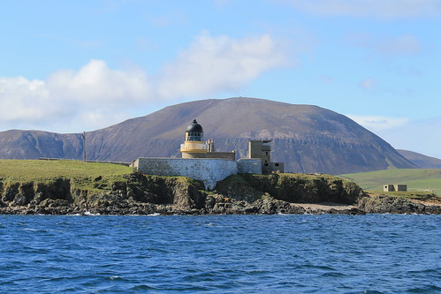
WWI/WWI-era look-outs on the shore of the isle of Graemsay with mountainous Hoy in the background
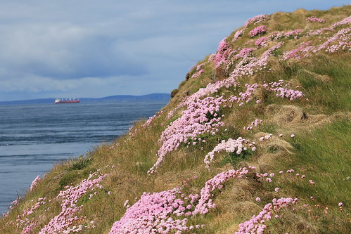
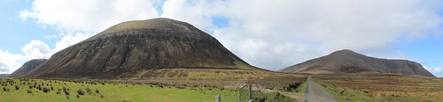
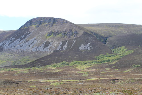
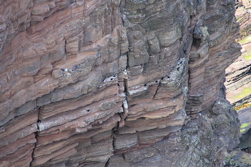
Hoy is a beautiful island. It has the most topography of any of the Orkney Islands and was visibly sculpted by glaciers during the last Glacial Maximum. One of its more modern features, however, is the Old Man of Hoy, the United Kingdom's tallest seastack (450 feet high)! A seastack is a tower of rock separated from the rest of a cliff-lined coast. They form as wave action strikes a rocky promontory, and as the waves refract around the head of the point, they erode the neck from two sides. Eventually, the neck of the promontory totally erodes through and all that is left is a giant stack of rock out to sea: hence the name seastack.

06042012 (24)
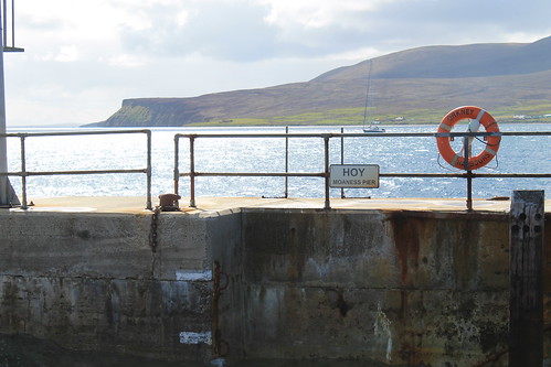
Docking at the isle of Hoy

To get out to the Old Man of Hoy, you have a few options. You can prearrange a cab to pick you up at the ferry dock, you can sign up for a guided tour, you can bike out there, or you can hike the 6.5 miles from the docks, through glacially sculpted valleys, and then up to the site. I bought some new hiking boots when I was in Michigan for my sister's wedding and since I didn't want to pay for a bike rental or a cab, I decided to hike. The first mile and a half are all up a one-lane road leading away from the ferry dock, through sheep pastures, and through some moors. The road eventually turns, but hikers continue the next two and a half miles through the glacial valleys, which are protected as part of the Scottish National Bird Sanctuary. Because of this, though, I was warned by a local Orcadian that you kind of have to keep your eyes open for any divebombing Great Skua birds (called, Bonxies by the locals). They kind of soar around above you and if you get too close to their nests, they will squawk and dive toward you. I won't lie, I had a few stones in my hands just in case, and even shouted at a few that I thought were flying too close to me! There was a little reservoir up in the valley that most of the bonxies stuck to, and once I was past that, they were no longer a problem!

06042012 (35)
The lonely road out to the hiking path to Rackwick on the isle of Hoy

06042012 (40)
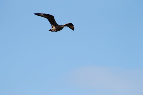
Watch out for the dive-bombing bonxies!

Further down the valley, tucked away in little stream valleys, are some of the last remaining wild Orcadian forest, that used to cover much of the islands. Over 5,000 years of constant settlement and agriculture, it's no wonder there is little left of these forests. But then the trail reconnects with the road which ends not much further in the little town (if you can call it that) of Rackwick.

06042012 (115)
Some of the original, most northerly native woodland in the British Isles

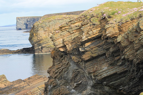
Rackwick is literally the end of the road, but it is a beautiful end of the road with a wide, sweeping beach with turquoise water, nestled between huge, enormous, sandstone cliffs. And I'm not talking 100-foot-high Sydney Coastal Walk cliffs, or even 200-foot-high Pictured Rocks cliffs, or even 400-foot-high Cliffs of Moher. These cliffs jut up 500-feet from the ocean far below (and they aren't even the tallest, which rise up over 1,000 feet!). So Rackwick is a beautiful end of the road, but not the end of the journey out to the Old Man of Hoy, which still requires a two and a quarter mile hike along cliffs and over coastal plateaus. But once you are there, it is such a treat! Standing 450-feet up from the ocean, far below, is this behemoth of stacked beds of sandstone, flanked to the south by similarly-high cliffs, and to the north by the massive 1,000 foot cliffs! Now, believe me when I say that the Cliffs of Moher are beautiful and stunning, but the fact that they are so accessible and overrun by tourists makes them a bit less wonderous, compared to these massive cliffs that only those willing enough to hike a few miles will ever get to.

06042012 (57)
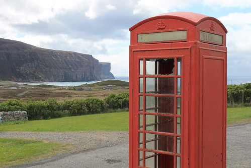
Old British Telephone booth at the Rackwick Hostel, looking down at the town and the massive sea cliffs

06042012 (75)
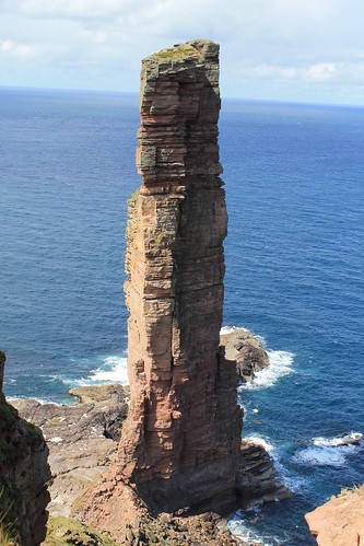
The Old Man of Hoy: 450 feet tall and the tallest sea-stack in the UK

06042012 (78)
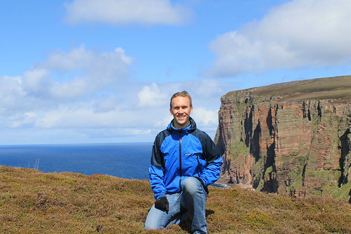
Me with the sea cliffs north of the Old Man of Hoy

06042012 (91)
Puffins! This was the best shot I could get, even with my 18x zoom lens... But some birdwatchers there told me of better places closer to Glasgow I can go to get better photos

I stayed out at the cliffs for a little while, enjoying my packed lunch of cheese, jerky, an apple, biscuits, and crisps, watching the sea birds (mostly seagulls, but I did see some puffins, too! - just very, very far below me...) and chatting with a few of the other visitors who were from all over the place: Germany, southern England, California... They all had a few good stories and we each helped the others take photos. It did start to sprinkle, just a thin band of rain, but it was also time to head back to the ferry dock. I wanted to take a more rigorous route up above the massive cliffs to the north, but being alone, without a detailed map, and on a time constraint, I decided it would be better to go back the way I came and leave the high-cliff route for another time. Back toward the ferry dock, a lot of tourists were having an afternoon tea at a little cafe. It was nice, but definitely priced more for the retired clientele who have a little bit more pocket change than your average student day-hiker, but I bought an Irn-Bru and gave my feet a rest in the yard, watching a chicken hobble around.

I had to catch the first afternoon ferry back to Stromness in order to get the right bus out to Maeshowe, which I wasn't able to get in yesterday. We had to wait for the ferry a little bit but it gave me time to explore the exposed rocky shoreline during low tide, which was covered in barnacles, limpets, algae, and seaweed. The ferry came and brought us back to Stromness where I had a little extra time before the bus, so I bought a beer at the Ferry Inn and listened to one final jam session by the remaining musicians in town for the Orkney Folk Festival. But then it was bus time and back to Maeshowe.

06042012 (157)
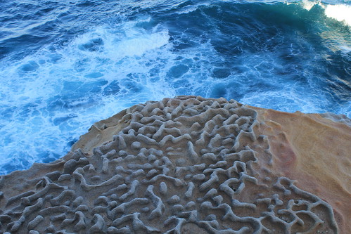
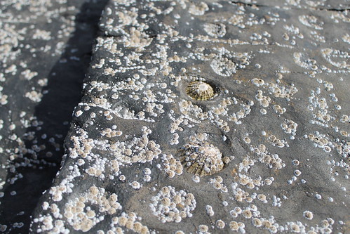
Limpets stuck to the bedrock at Hoy Harbor during low tide. As water washes over them, it erodes little pockets around each limpet creating a pitted pattern on the rock.

Maeshowe is a fantastic Neolithic site, nearly 5,000 years old. You have to book a tour in advance, and in the summer there are extra "twilight" tours in the evenings, which aren't really twilight since the sun pretty much never sets. To get into Maeshowe, you have to stoop quite low and walk through a ten-meter passageway lined in massive, single blocks of stone. Once inside, you're able to stand up in a square chamber with what was once a corbelled ceiling (but is now a poorly constructed brick dome structure put in place in the early 1900s). Maeshowe is similar to other chambered tombs of the area in that opposite the door and on either side wall are two recessed and L-shaped chambers. In other tombs of this age, human bones have been found stored in these chambers, grouped by bone-type, rather than full skeletons. It is thought that Maeshowe served a similar purpose but very few bones have actually been found there. It may have also served a more ceremonial purpose, archaeologists think, suggested by the fact that the entrance to the tomb directly faces the setting sun on the Winter Solstice. Curiously, on the solstice, the sun sets behind the massive mountains of Hoy, and it is thought that they also served some spiritual purpose. Furthermore, the ceremonial significance of Maeshowe is suggested by its proximity to the Standing Stones of Stenness, the Ring and Ness of Brodgar, and the Barnhouse Village.

In the 12th century, multiple groups of Vikings were vying for control of Orkney and one group started off one morning in Stromness but got caught in a storm and took shelter in Maeshowe, leaving cryptic messages of the runic alphabet carved into some of the stones. They spoke of the treasures of the North and one claimed to be a master writer of runes who and carved his message using a very famous axe, used to slay Gauk - don't ask me the history of that; all I know is that the axe was well-known.

My favorite bit about Maeshowe, though, again were the slabs of rock. The entrance tunnel was lined and covered with ten-meter long single slabs of sandstone, and the lintel above each of the recesses off the main chamber, which were five meters by at least three meters, were each carved of a single slab of rock. How those people 5,000 years ago were able to move such large pieces of rock over large distances still baffles me as well as archaeologists, and as to how it was done is still anyone's guess.

06042012 (197)
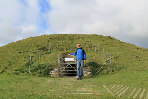
In front of the entrance to Maeshowe. No photos are allowed inside, but it's pretty amazing

06042012 (210)
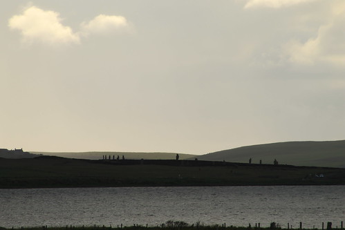
One last look over to the Ring of Brodgar

Upon leaving the tomb, I gave one last look around the landscape, taking a few more photos, before heading back to the visitors center to wait for the last bus into Kirkwall. I bought a few postcards and got some good music suggestions from the woman working the shop, and indulged myself into a wee tub of ice cream from the Orkney Creamery, which was delicious (I suggest the Toffee Swirl and the Orkney Original).

Back in Kirkwall, I ran into some girls who were out at the Old Man of Hoy when I was there that day, and we chatted a while over some coffees and snacks in a little craft shop/coffee house, Judith Glue. The girls were fun to chat with, but they had already eaten dinner and I needed some substantial food before 9pm, so I said goodbye to them and headed out to see my final fish and chips of the trip. I caught the shop just before they closed and took my food out to the harbor to eat. It wasn't quite 10pm yet and I realized that I did want to purchase something to remember Orkney by, and I went back to Judith Glue (which stays open until 10pm!) and purchased a few prints done by a local artist and a bottle of Dark Island, brewed by the Orkney Brewery - as suggested by a man at the pub where I got dinner the night before - and headed back to my hostel where I watched the Queen's Diamond Jubilee concert at Buckingham Palace and wrote my postcards. That night, as part of the Jubilee, beacons, or torches or bonfires, were being lit around the UK and the world in commonwealth countries. Stromness had their own beacon and I was tipped that Kirkwall would be having their own as well on top of a radio-antennae hill visible from the hostel's kitchen window. I kept getting up to see if I could see the fire, but it was either too small or they didn't have one, so I stayed in, repacking my bags, and finally dozing off to sleep.

My legs were sore, feet were covered in blisters, and my brain hurt from trying to piece together all the Orcadian history I had taken in over the past few days. But I fell asleep the moment my head hit the pillow and I would soon be saying goodbye to this beautiful but chilly island paradise of northern Scotland.

Creative Commons License
This work by Eric W. Portenga is licensed under a Creative Commons Attribution-NonCommercial-NoDerivs 3.0 Unported License.