Showing posts with label Islands. Show all posts

Saturday, February 14, 2015

Scotland: Kilmartin Glen, Mull, & Iona

Dates Traveled: 27-29 December 2014

Christmas was once again spent away from family this year, but this year would at least be exciting. One of my friends and I decided to head west from Glasgow to Oban with some stops along the way. When I moved back to Glasgow from Australia a year ago, a friend of one of my friends was looking at a wall map of the British Isles in my flat, pointed to an area south of Oban, and said, "You must go here, to Kilmartin Glen." He said that Kilmartin Glen is one of the most overlooked destinations for anyone interested in Scottish history and neolithic sites. So, after a day of recovering form boxing day laziness, we headed out from Glasgow.
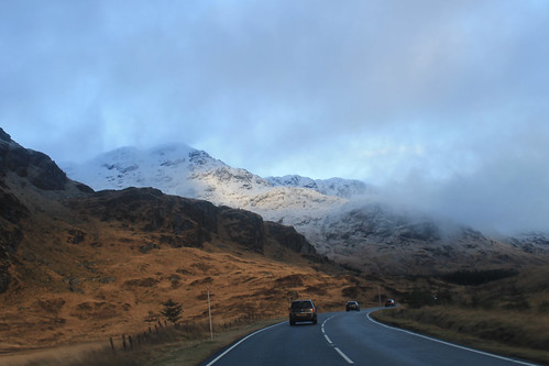
Along the A83
Driving along the A83 between Loch Lomond and Inverary
Winter is an absolutely beautiful time to visit Scotland. Sure, the days are incredibly short, but the snow on the hills makes it unlike anywhere else. Once away from the main cities, the roads get narrow and windy, which makes for getting anywhere quickly quite tricky! It took us a while to get out to Kilmartin Glen, via a coffee stop in Inverary, but a little after noon we pulled into our first stop, Dunadd, which was the first site of the first kings of Scotland, having been in use since the Iron Age. On the little hill above the glen is a rock with some footprints carved into them, possibly where the kings looked out - I imagine much like Mufasa and Simba from Pride Rock :)

A little bit further down the road are a series of standing stones dating back 5,000 years. We missed the winter solstice only by a few days, but it's pretty amazing how these stones would have lined up with the setting sun, even after 5,000 years! I'm often really amazed by how after thousands of years, and with all of our modern technology and knowledge, we still have no real idea what these stones or circles were used for! And while not as grand as the Ring of Brodgar in Orkney or as circular as the Drombeg Stone Circle in southwest Ireland, the stones are just as enigmatic, and there are a lot of them, including one site where five stones make an X figure in a field, apparently a very unusual arrangement. Starving, we stopped in at the Kilmartin Hotel and had a tasty pub supper before exploring the curchyard across the street with brilliant scenery looking down the Glen.

There were still a few things we wanted to see before it got dark and before we got to Oban, and even though it was only 3 o'clock in the afternoon, we were running short on daylight, so we hit the road again, winding around the coast, to the Bridge over the Atlantic. To be fair, this is a very nice looking stone bridge, arching high over a small tidal waterway, technically part of the Atlantic Ocean, separating the Scottish mainland from the small Isle of Seil. Apparently nowhere else (maybe in Scotland) is there a bridge over the Atlantic, so it is only here you can say you've "driven across the Atlantic Ocean." Not really much to see, we kept on to the small town on Seil of Ellenabeich, an old slate mining town that now consists of three rows of whitewash cottages. A beautifully small town that I would have liked to have stayed in a bit longer. Would have been a great place to write up my PhD thesis! While in Ellenabeich, the sun went down and we didn't want to be stuck on unlit country roads for too long, so we headed in to Oban, checked into our hotel, and met up with one of my Uni friends who was home visiting family for the holidays.

Mull Panorama
Snow-capped mountains on the Isle of Mull with Duart Castle in the foreground from the ferry from Oban to Mull.

We got up early the next morning, a brilliantly clear but chilly morning, to catch the ferry from Oban out to the Isle of Mull, a rugged island about an hour offshore from Oban. The views from the ferry back to the mainland of snow capped mountains were amazing, not to mention the snow capped peaks of Ben More, the only Munro on Mull. A little note for visiting Mull in the winter: Don't plan on relying on public transportation, especially on a Sunday! We were lucky to have a Range Rover, so the small single-track roads and ruts of Mull were a piece of cake, but be careful if you have a smaller car not to go off the edge of the road or you will get stuck! We headed immediately out to the westernmost point of Mull, a town called, Fionnphort, where we waited for the quick ferry out to the small Isle of Iona. Again, visiting in the winter and on a Sunday, you run the risk of either the ferry not running, or only making one trip out to Iona, but not back, so it's suggested you call the portmaster on Mull the day before to make sure the ferries are running!
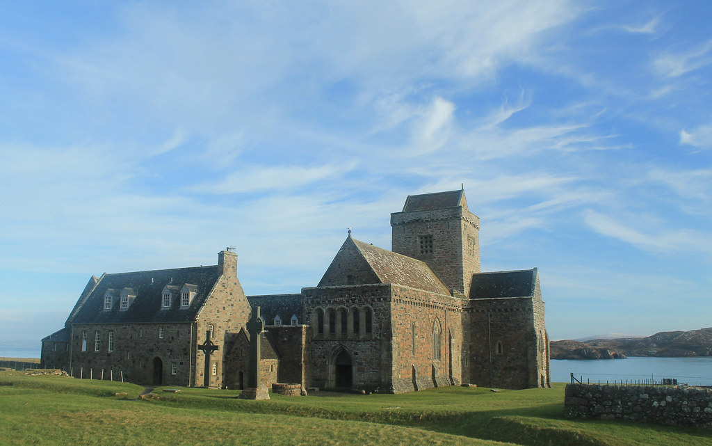
Iona Abbey
Iona Abbey
The sky was crystal clear, and though it wasn't windy, it was really cold! But while waiting for the ferry we did get to see a small fishing boat loading up for the day, and it must be quite a regular occasion because there was a seal who sidled right up to the boat begging for a bit of breakfast! The ferry finally arrived and we walked on, making sure to ensure it would come back from Iona! Now, Iona is a beautiful little island and I wish we had more time to spend there, but with the two hours we did, we made sure to walk over to the famed Iona Abbey, the former Catholic monastery where the Book of Kells was written. The Abbey survived Viking raids as well as the Protestant Reformation, and is now part of the Church of Scotland. So many tourists come out to Iona in the summer, it was nice to experience the island in winter when even the hostels were closed for the season! BUT, if you go on the weekend, you don't have to pay to get in to the grounds! We took a little walk up to the highest point on Iona, Dun I, for some breathtaking views to Mull and so many other Inner Hebridean islands.

Running short on time, we headed back to the ferry and crossed back over to Fionnphort, accompanied by dolphins jumping out of the water and playing in the wake of the ferry! Back in the car, we decided to take the small winding road around the rest of Mull. Now, I thought the road from the Mull ferry to Fionnphort was small, but it was nothing compared to the B8035, which was tucked right along the coast with rocky cliffs on one side, but provided amazing scenery, especially during sunset on such a clear day! The B8035 turns onto the B8073 and the road climbs up some very steep hills that any small car would have some trouble getting up! If you're in a small car, you definitely want to take the B8073 counterclockwise from Tobermory where it will be easier to go down these roads than up. Daylight was nearly gone as we arrived to Calgary Beach in the small locality of Calgary, the same that the Canadian metropolis is named after! But we couldn't stay long since the sun had now set and we still had about 30 minutes to drive to Tobermory for a quick fish dinner (not many places open on a winter Sunday), very quick because we had to get back down to the ferry docks to catch the last ferry back to the mainland.
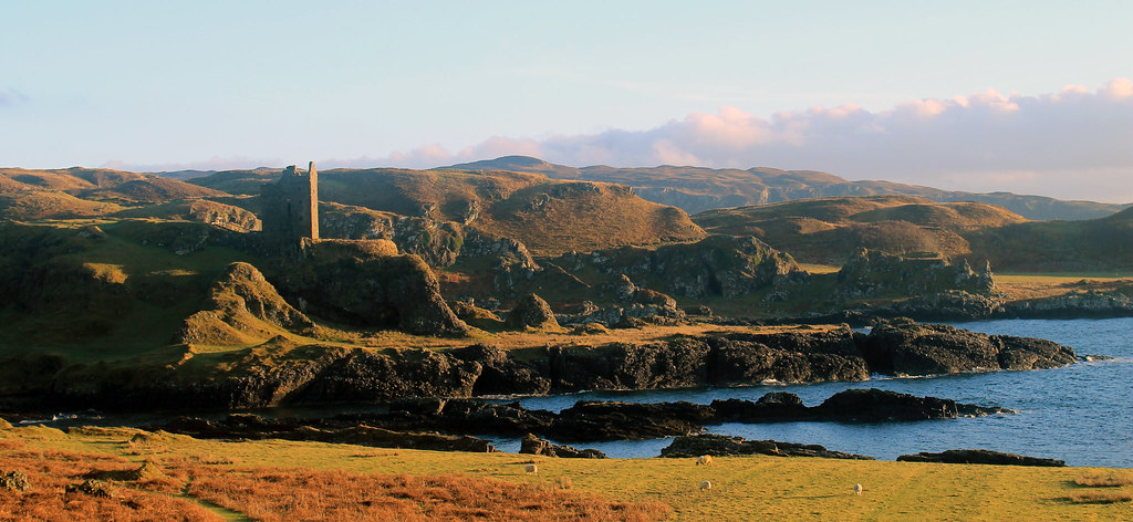
Gylen Castle and Kerrera Coast
Gylen Castle on the southern end of Kerrera
The following morning was yet again a clear day on the western Scottish coast, though much colder! Not wanting to waste time, we grabbed some breakfast and went to the small local ferry from Oban out to the small island, Kerrera. A privately-owned ferry, you signal the owner that you want a ride by sliding a big panel open on the mainland, revealing a big black square, and upon seeing it, the ferryman comes over to pick you up for the 5 minute crossing. We decided to do the 3.5 hour loop down to Gylen Castle at the southern end of the Island and back. Though not a strenuous walk, it felt long because it was so cold, especially in the shade, but the destination was amazing - a square castle with a small footprint exposed on a tall rocky knob over the coast. The castle was besieged and burned in 1647, though recently the Clan MacDougall began restorations. It's surely not much of a castle, but its position in the grassy hills along the coast sure makes it a great place that we had to ourselves! The rest of the circuit along the west side of the island isn't as scenic, and was a bit mushy underfoot, but there were a few brilliant moments in the setting sunlight over to Mull. Back in time for the ferry back to the mainland, we hopped back into the car and headed back up to Oban to pick up my friend who was coming with us back to Glasgow, and with that we were off back home.

Though I think we lucked out, weather-wise, the weekend was a great and most welcome break from city life in Glasgow, and so easy for a few days! Enjoy the photos:

Sunday, April 6, 2014

Australia: Whitsunday Islands in a Weekend

Trip Date: 06-08 September 2013


A few months ago, back in early September, I took off early and flew from Sydney to Hamilton Island, one of the entry airports to the Whitsunday Islands on the central Queensland Coast. I’d heard about the Whitsundays from a couple of friends who’d been there before and the more I looked into it, the more these pristine islands, world-famous for their sailing cruises, appealed to me.

Whitsunday Islands
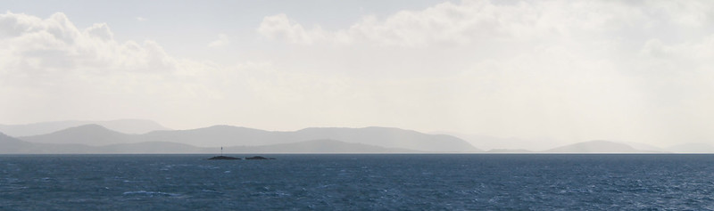
The beautifully hazy Whitsunday Islands

If you’re traveling on a budget and have the time, you might consider flying in to Mackay a few hours to the south. But if you sign up for discount airlines’ emails, you can get affordable tickets right into either Proserpine airport at Airlie Beach (on the mainland) or into Hamilton Island airport on, well, Hamilton Island. When I booked my tickets Hamilton Island was my best entry point and it was still cheaper and more convenient to buy a round-trip ferry ticket to Airlie Beach on the mainland than it is to fly into Mackay and find your way up to Airlie Beach. Alternatively, if you have a good couple of hundred of dollars in your pocket, which I as a student do not, you can just stay out on Hamilton Island in one of their very swanky accommodations.

I got in on a Friday afternoon while the flight was smooth most of the way up, the winds coming in off the Pacific made for a very bumpy and tipsy landing – one of the worst I’ve experienced in a while! With that said, the views coming in to Hamilton Island are stunning. Beautiful blue water, dozens of lush green islands, and stunningly white sandy beaches. It makes landing on a short island runway all worth it!

The weather wasn’t all that great and I began preparing myself for a less-than-relaxing sunny beach weekend than I expected. While waiting for the ferry to take us to the mainland, the clouds came in dark and ominous and at times spitted a bit of rain. Back in February of 2013, a massive storm struck the islands causing widespread damage that was still visible in September as some boats were still washed up onto breakwaters, shoals, and jetties – but of course none of the tourism ads show that but rather want you to think it is always sunny here (something the girls in the row in front of me on the plane clearly had in mind). It all just depends on what you get and you should just prepare yourself to have fun no matter what.

And that was my plan. I’d booked a bed at the YHA in Airlie Beach and planned on doing some beach-visiting, snorkeling, and bushwalking while I was here over the next day and a half. Like all other YHA hostels I’ve stayed at, the one in Airlie was fine for accommodation, though maybe a bit more utilitarian. It was quiet when you wanted it to be and comfortable, though, so I had no problems with it. It is a backpackers’ accommodation though, and one thing you can’t get away from is the constant pressure to socialise with anyone else who happens to be staying in your room. I’d booked a bed in a dorm and there was a nice guy from Sweden in there who immediately started chatting me up. I was fine with that for a few minutes, but the incessant need for him to keep asking me questions about where I was from, why I was in Airlie Beach, and what I was going to do there started driving me crazy. After a series of me giving him one word responses, I decided I needed a sign that reads, “The only reason I’m staying here is because it’s cheap,” especially if I keep staying at hostels rather than the more expensive beach-side resorts.

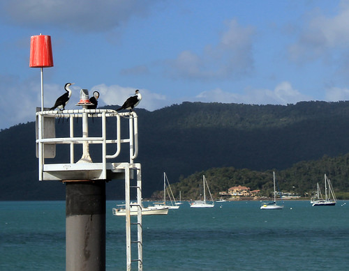
Cormorant Welcome
The cormorant welcoming committee in Airlie Beach
I really wasn’t trying to be antisocial, but I had already decided on the flight in that this was going to be a nice me-weekend. Unfortunately, Airlie Beach is just not a place for that as backpackers are literally everywhere and the atmosphere in nearly all of the local pubs and bars plays testament to the party scene Airlie is so well known for.

I decided on a pub for a burger desert – it doesn’t really matter which pub; they’re all crap and went back to the hostel to test out my new LifeProof waterproof iPhone case. Initially, I’d wanted to invest in a GoPro camera for all of the snorkeling I was going to be doing over the next few months, but they’re not cheap and instead I decided an iPhone case was the next best thing. Customer reviews did nothing but rave about LifeProof cases and for $70, I figured I’d take the risk and after unpackaging the case in the hostel and submerging it in a rubbish bin full of water (without the phone in it, of course) for half an hour, the inside proved to be perfectly dry. I was happy with it enough to give it a go out on the reefs.

Early the next morning, me and a few other backpackers (I hate using that term for myself, but it’s just easier) were picked up from the YHA by Ocean Rafting, a company I found through Trip Advisor which is eco-certified and boasts their pro-environmentalism vehemently on their website. Considering the Earth is continuously warming and ocean acidification an ever increasing problem, I figured it would be responsible of me to go out to the islands and reefs with a company that so clearly cares about the environment they take tourists to. Ocean Rafting also was appealing because their boats only take ~25 people on them so you get a much more personalised and intimate tour of the Whitsundays. Finally, Ocean Rafting has a sister company in Cape Tribulation (Ocean Safari) and you can get a small discount if you book a combo trip with both companies and since I’d be going up to Cape Tribulation in October when my family visited, I figured I might as well save a few bucks!

We were some of the first ones out to the dock where our boat, Thunderstruck, was moored and it took a while for everyone else on our tour to show up, but soon we were all squeezed into our wetsuits – a new experience for me – and stepping on to Thunderstruck which was an open-topped speedboat with large pontoons on either side. We could either sit on the benches or on the pontoons and our van-driver that morning said today was a perfect day to ride up front or on the pontoons since the swell coming in off the ocean was still pretty big and the boat was designed for wavy conditions. I had no intention of missing out on any bit of adventure, so I rocked on up to the front row of benches with a truly Irish couple – the guy had a penchant for saying, “Fuck” and “Shit” every other word – which got to be a bit much by the end of the day, but they were good company.

The sun was not out in full brightness yet, but I could tell that the rough weather experienced on my arrival the night before was clearing up and by the time we picked another few people up from Daydream Island and passed through the Molle Islands, the clouds had disappeared and it was obviously going to be a great day! There are dozens of islands in the Whitsundays and when big ocean swells hit them, the waves are refracted around the islands, funneled between narrow passages, and come at you from every which way, which made our boat ride out to the channel between Hook and Whitsunday Islands incredibly bouncy and fun! People were screaming as the prow of the boat lifted up over a wave and came crashing down into the trough on the other side. Our morning driver was right – the choppier the water, the better the ride is on these boats!

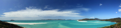
We passed through the narrow channel between Hook and Whitsunday Islands and turned right to follow the shoreline of Whitsunday Island which rose up from the sea in steep, bare granite cliffs. It wasn’t before long and the boat slowed down on the opposite side of a skinny peninsula that separated us from the famous Whitehaven Inlet and beach. We hiked up to the ridgeline of this skinny peninsula barefoot and in our wetsuits through the subtropical heat and humidity to a vantage point from which you can see Whitehaven Beach in all of its pristine, white, sandy glory!

Whitsunday Islands National Park
Beautiful turquoise waters and white sand of Whitehaven Beach and Whitsunday Inlet.

To the local Aboriginal people, the Whitsunday Islands are sacred and focus heavily in their Dreamtime stories and of particular significance are the literally thousands of stingrays that call the estuary home. The estuary itself is not terribly long but it is quite wide and the stream flowing out to the ocean is clearly marked from the white sandy deposits by its bold, brilliant, turquoise colour. From the viewing platform, you see not only the stunning estuary, but you look down over bright white sand spits built by longshore currents transporting sand down from Whitehaven beach which stretches as far as you can see in front of you. Geologically, the sand on Whitehaven Beach has been transported hundreds of kilometers along the Australian coast and the purest quartz sand grains are eventually deposited along the beach as coastal currents eddy between the Islands. The fine silica sand is so pure that even on the hottest days it is quite cool to the touch because quartz just does not retain heat well. It is easy to see why the Whitsunday Islands are designated a UNESCO World Heritage Site.

We didn’t linger long at the viewing platform, abandoning it for lunch down on the white sand spit at the mouth of the estuary. The great thing about the tour with Ocean Rafting is that they are the only company allowed to anchor in the estuary itself. No other company is allowed to anchor here and no one is allowed to remove anything from the beach or any of the islands due in part to their listing as a World Heritage site, but also due to their sacred significance to the local Aboriginal people. Only one organization has legally been allowed to remove sand from the beach. Back when NASA was building the Hubble Telescope, they needed the purest silica in the world to melt and form the telescope’s lenses, as any impurity at all would ruin the telescope’s capabilities of photographing space’s wonders.

We spent about an hour on the white sand spit trying to keep our lunches from being stolen by seagulls. No one really talked and while I think it was because of the sun and hunger, I’d like to believe it was because everyone was in awe at this magnificent gem of natural beauty!

After lunch, our boat took us back north toward Hook Island and through what the captain and tour guide referred to as the Devil’s Washing Machine – an area of water where the swirling eddies converge together and the ocean’s wave double in height! Sitting on the side pontoon of the boat, with nothing to hold on to but a small canvas strap between my legs, this proved to be much bouncier of a ride than if I’d had a seat in the boat but it was amazingly fun feeling your body leave your seat as the boat falls back to the water after running off the crest of a wave!

Soon we arrived at the first of our two snorkeling sites on the east side of Hook Island. This was the first time I was going to have willingly jumped into the ocean since I went snorkeling in New Zealand’s Bay of Islands, which was the beginning of conquering my personal and very irrational fear of the ocean! I knew that putting myself in with a group of people who weren’t afraid to just jump in the ocean would pressure me into not being a chicken, but then while the captain was explaining what we’d be seeing at this site, his deckhand pulled a jar of fish food out and started throwing the little kernels of food into the water. As he did this schools of fish too many to count would swarm the water where the food landed – mostly schools of a blue-yellow fish (NOT SURE WHAT IT’S CALLED??).  But what worried me the most was the much larger Maori wrasse – massive fish that can grow to six feet in length with large beak-like mouths. Supposedly, Maori wrasse are harmless, but their size was intimidating enough for me to hold back on the boat much longer than everyone else, petrified to jump in in case one of these massive fish were to sneak up on me!

But money talks, and I reminded myself that I’d bought the waterproof iPhone case for this purpose and that I needed to put it to good use. I slipped on my flippers, tucked my camera into the sleeve of my wetsuit, donned my mask and snorkel and flopped off the side of the boat. I was in, and it was amazing! Whereas we saw heaps of sea urchins and seaweed amongst the rocks snorkeling in New Zealand, there was nothing but fish and coral here! Huge stacks of all of the coral you’ve seen in movies, books, and pictures and just as many types I’d never seen or heard of before! There were loads of fish – mostly the ones schooling around the food but also rainbow parrotfish, big fish, small fish, and yes, even the great Maori wrasse which I saw sneaking up on me from behind, though turned away before getting too close to me!

We were in the water for about an hour before being called back to the boat, which didn’t take me long as I didn’t dare venture too far away, but took some of the more intrepid explorers a wee bit longer. Because of the windy weather that hit the islands on the previous few days, sand had been stirred up all around the islands that made visibility low and the captain thought we might have better luck a few bays further around the island. We made the short trip to the next bay and spent another hour or so exploring the corals here. Indeed visibility was better and I was a bit more adventurous and tried seeing as much of the reef as I could. It was truly like being in an underwater wonder world and even I was amazed at how quickly my inhibitions melted away under the spell of the reef.

Hook Island Reef
Parrotfish on the reef!
I think everyone should be able to experience a tropical reef up close at some point in their life  - though the scientist in me cautions anyone who does to be very conscious about what company they use to get to the reefs. Climate change, warming ocean waters, and acidifying oceans are killing reefs all around the world. They are some of the most delicate and fragile ecosystems in the world yet are crucial for the survival and sustenance of all the oceans.

It was getting late and we boarded the boat one last time before finishing our circumnavigation of Hook Island, past the old resort of Hayman Island, and back toward Airlie Beach. The seas were still rough but I wasn’t upset I once more found myself riding the pontoon on the way back for one of the wettest rides on the boat!

There’s nothing to report from my second night in Airlie Beach because it’s a dive and not worth wasting words on.

I woke up early on my third day in the Whitsundays and walked back to the ferry docks to catch the first ferry back to Hamilton Island. My flight back to Sydney wasn’t until later in the afternoon, but I wanted to do a bit of bushwalking and it looked like there were some great trails on Hamilton Island. Indeed, once you get past all of the resort villas, bungalows, hotels, condos, and conference centres, you find a track that leads up to the rocky lookout called, Passage Peak.

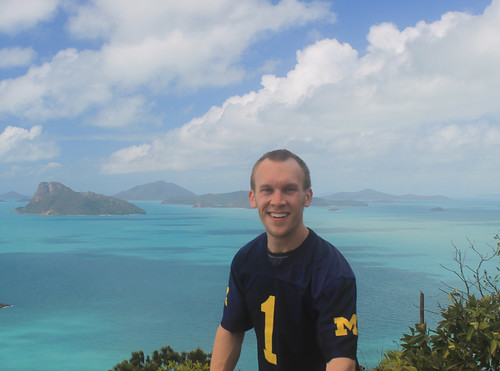
It only took about an hour to reach the peak, though unless you’re an avid hiker, I’d plan on it taking more than that. The weather was hot, but the sky was perfectly clear for looking out over the islands from one of the highest points in the islands! Fluffy white clouds marched through the sky in endless precession, casting shadows on the clear turquoise water. I had a nice chat with some other bushwalkers at the top and they pointed out some pairs of whales they’d seen while I told them about Whitehaven Beach which you could see over the lush green slopes of neighboring Whitsunday Island. Though it was Sunday in Australia, it was a Michigan Game-Day Saturday back home, and in true fashion, I proudly wore my UM Jersey, which I also had to explain to the other hikers, but they generously took photos of me, saving me from yet more selfies. Eventually they left and thus left me to one of the most spectacular viewing points of natural beauty I’ve ever seen!

Wherever You Go, Go Blue!
Going Blue during a bushwalk to the summit of Passage Peak on
Hamilton Island. I believe we beat Indiana that day!
I had plenty of time to walk back to the airport, so I took my time with it singing Michigan Songs from Glee Club on the way down since I think it was the weekend we beat Indiana. I called and chatted to my sister over lunch and then made my way to the airport which is conveniently within walking distance from the marina and after not too long was back in the air headed home to Sydney. 

My weekend in the Whitsunday Islands reaffirmed what I’ve learned so often in Australia: it does not take much time or money to have amazing experiences in beautiful locations. I was away for less than three days, yet I have some of the most vivid memories of nature, landscapes, the ocean, and animals I’ve ever had. If you get the chance, go! To the Whitsundays, absolutely, but also to anywhere you’ve been wanting to see!
 

Friday, July 5, 2013

Australia: Gordon River Cruise

Travel Date: 25 April 2013

25APR2013 (1)
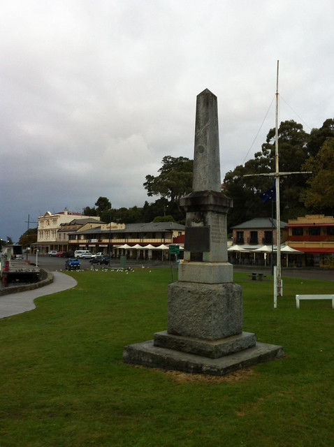
ANZAC Park along the waterfront in Strahan
I woke up early in the morning at the YHA in Strahan, packed up my things, and loaded my bags into my rental car, and drove down to the Esplanade in the town centre for my first (and only) ANZAC Day Dawn Service. The Australia and New Zealand Army Corps (ANZAC) was the first organised armed services of both countries and were first deployed in World War I at the Battle of Gallipoli which was an effort by the Allies to capture Constantinople and thus monitor/block all sea trade to Russia (thanks, Wikipedia). What I did not have to look up, though, was that the battle was not successful for the Allied Forces and many Australians and New Zealanders lost their lives. ANZAC Day memorialises this Battle as well as all other military excursions that the two countries have been involved in since. It's essentially the Australian and New Zealand version of Memorial Day. Traditional services are held at dawn throughout Australia, and Strahan was no exception. I stopped in at the coffee shop among the 60 or so townspeople who were up early for the service. Soon, the townspeople formed a procession 3-across and walked over to an obelisk in ANZAC Park across the street (while I, and any other tourists, just wandered en masse). There was a nice little service with some prayers being read, a poem by a local high schooler, and some words from the town's mayor - all of which was constantly interrupted by a hoarde of geese, ducks, and seagulls in the park behind us, so it was kind of hard to hear. Then the mayor tried playing a recording of tradtional ANZAC music on a portable CD player, but couldn't get it to play. After about five minutes, the young high schooler who read the poem stepped up to help the elderly mayor. Thinking a young person would have the CD player going in no time, it surprised me when after another five minutes passed and the music hadn't started. It was then I realised how unique my age is: the mayor was maybe too old to be familiar with CD players and the high schooler was so used to iPods and mp3 players that she also didn't know how to work it! They eventually realised that if they put the CD player on solid ground, it would play just fine. The service soon ended and most everyone headed into the local hotel (pub) for breky and a coffee and rum mixture. I settled for coffee (plain) and a sandwich from the cafe next door.

It was a very bleak, grey, and drizzly morning, but I'd booked a ticket on the Gordon River Cruise (highly recommended by tour guides). Strahan is nestled in a little cove off of Macquarie Harbour, Australia's second largest harbour next to Melbourne's Port Phillip Bay, and fed by the Gordon River, which extends up into the vast wilderness of southwest Tasmania. I booked the trip for three reasons. Firstly, not having much time to hike into many of the wilderness areas of Tasmania, I thought this would be a fantastic way to "get into" the wild (yes, even if it is aboard a luxury catamaran). Secondly, it also stopped at the famous Sarah Island - one of Tasmania's most feared convict colonies out on a tiny island in the middle of the harbour - and I wasn't sure if I'd get to learn anything about Tasmania's harsh convict history during the rest of my trip. Thirdly, it included lunch!

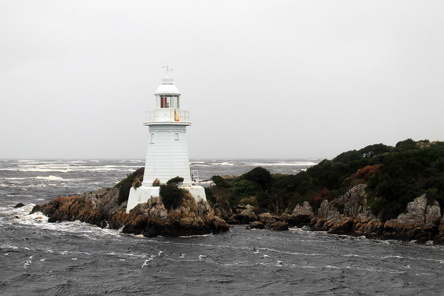
The cruise left the docks in Strahan and immediately headed out toward the entrance to the harbour where we passed a few different lighthouses while passing through Hell's Gate. The convicts called the entrance to Macquarie Harbour Hell's Gate because of its isolation and hardships they knew they'd endure on Sarah Island as well as the fact that even though the surrounding area is beautiful, attempted escape almost certainly would lead to death either by British soldiers or the treacherous nature of the environment. Hell's Gate is only  a few tens of metres wide and is very shallow, so not too many large vessels can enter the harbour. Also because of the shallow and narrow entrance, it takes ebb tides more time to push their way into the harbour. In fact, the upper few metres of the harbour's water is freshwater supplied from the surrounding rivers and stained brown with tannin because the narrow entrance to the harbour makes it more difficult for the tides to flush out the harbour!

25APR2013 (30)
Lighthouse at Hell's Gate, the entrance to Macquarie Harbour, Tasmania
This has an added benefit to the local fishermen. Salmon and trout were introduced to Australia from Great Britain and because they require a certain balance of fresh and salt water, Macquarie Harbour is the perfect place for fish farms, of which there are many.

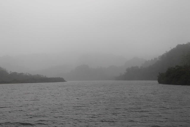
The boat turned around outside Hell's Gates, not wanting to get battered by the huge ocean waves, wind, and rain and went back into the harbour toward the opposite end where the Gordon River flows into it. As soon as we neared the entrance to the river, the water became much calmer and though it was still rainy and gray the trip became a bit more relaxed. We traveled up the river a few kilometres and learned about the native Huon Pines which grow in the area. Convicts at Sarah Island predominantly built ships out of the Huon Pine because the pine's pitch contained an oil which prevented worms from boring into the wood. Logging of the Huon Pines was so intense that all operations have since been halted and the species protected. Now, only National Park officials can remove Huon pine wood from the forests, and even then, it can only be wood from fallen trees. No Huon pines can be cut down.

25APR2013 (74)
Mouth of the Gordon River, flowing into Macquarie Harbour, Tasmania
We got off the boat and had a little walk on a boardwalk through the rainforest, which was very very rainy and allowed us to get up close with the Huon pines and a number of little mud chimneys built by crabs excavating down into it. Back on the boat, though, a buffet lunch was served with some of the freshest salmon you could hope for and local Tassie apples. Delicious!

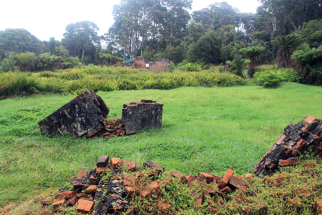
The rain had stopped momentarily as we approached Sarah Island, home to one of the worst convict settlements in Tasmania, reserved only for those who repeated offense after arriving to Australia. The island is fraught with stories of cruelty, backstabbing, coercion, treachery, and violence I cannot even begin to recount the tales we heard. But the end of Sarah Island came with the installation of a commandant who had previously been a ship builder with no experience of managing convicts. But as soon as he started his post at the island, the violence decreased, the escape attempts stopped, and productivity increased immensely. It turns out that when you give convicts special things they want like alcohol and dignified sleeping quarters, you could get in return a very productive work force. But after news of fair treatment toward the convicts at Sarah Island reached the higher-ups in the British military, the settlement was shut down.

25APR2013 (122)
Convict settlement ruins on Sarah Island in Macquarie Harbour, Tasmania
Having spent enough time outside on the boat, I stayed inside the rest of the way back to the wharf. Arriving shortly after 2pm in Strahan, I rushed to get to my car because I knew I had very limited hours of daylight remaining and a very long way to go to get back to Hobart for the night! But as luck would have it, the rain started back up as soon as I got back in my car. Not just a drizzle, but one of the most blinding, white-out deluges I've ever driven through. I put my trust in the little car and its tires and just started heading down the road trying not to slow down through the very rough driving conditions where rain was flowing down the road and around corners. My wipers, though on at the highest setting, couldn't keep up with the rain. I bought petrol in Queenstown and then started my ascent into the mountains.

The change from the day before in the mining area, where all the hills had been stripped of vegetation and soil was unbelievable. Every single crevasse or nook between hills was GUSHING with unbelievably voluminous waterfalls! With nowhere for the rain to seep into, it just collected and rushed downhill!! The rain continued as I got up into the mountains, and though I was making good time, I was surely driving a little too dangerously for the conditions. But finally, a few hours later, as I came closer to Lake St. Clair, the rain let up as the weather was held back on the western side of Tasmania by the highly elevated mountains. While still wet, the rest of the drive was fairly smooth and pleasant and I made it back to the Hobart airport to drop of my rental car only about an hour after the sun went down.

Creative Commons License
This work by Eric W. Portenga is licensed under a Creative Commons Attribution-NonCommercial-NoDerivs 3.0 Unported License.