Back in early April, while everyone in Australia was taking their Easter Friday and Monday off of work, I was grading assignments and in my lab working, being the diligent PhD student I am! But I needed a getaway, and part of my excuse for working over Easter was that I'd previously purchased a round-trip flight down to Tasmania for five days in late April.
I needed a break. After four solid months of slogging through lab work, research, writing, reading, and teaching, I needed to step off the Sydney merry-go-round or go insane. Having moved to Glasgow in winter of 2012, then to Sydney in August, I pretty much had a year of winter immediately followed by the Australian summer with no change of seasons to speak of and definitely no Fall, which is my favourite. Sure I got a little taste of Michigan Football last September-November, but no pumpkin spiced lattes, no leaves changing colour, nothing. But the nice thing about Tasmania is that it is as far south from the Equator as Michigan and Vermont are north of it, and April in Tassie would be the same as October in the northern hemisphere. In other words, it was Fall!
 |
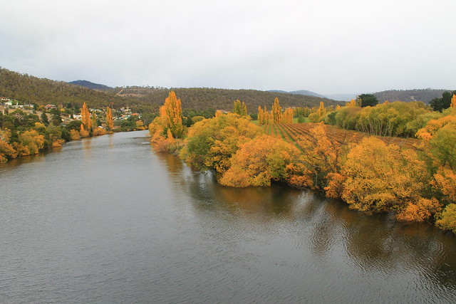
| Fall colours along the River Derwent in New Norfolk |
My first stop wasn't planned until Lake St. Clair in the Tasmanian central highlands, but after picking up coffee in New Norfolk - a town originally set up as a new homebase for Australian convicts stationed out at the soon to be abandoned Norfolk Island camp in the Tasman Sea - I crossed the River Derwent and had to stop because the trees along the riverbanks were on fire with autumnal colours! It was beautiful! From what I'd heard about Tasmania and the Tasmanian culture of environmental awareness and power of purchasing locally, I imagined it to be much like Vermont in the US. The similarities, I would find out, were uncanny, and the trees along the river were just the beginning. I do have to say, though, that this is the only time I've been happy seeing invasive species; you see, no native Australian trees change colour with the seasons, only the imported species from Europe and North America!
Continuing along through pastoral farming/grazing communities, the Lyell Hwy suddenly started its ascent into mountains and the roads became narrow, steep, and windy (and windy)! I passed some of Tasmania's many hydroelectric facilities in Terraleah and the road then spit me out onto the highland plateaus just east of the central Highlands.
Tasmania's central highlands and the entire southwest quadrant of the island are all preserved as National Parks, most of which make up the Tasmanian Wilderness World Heritage Area, and while you can access many places in those parks, the majority of it is left as a natural wilderness for your experienced outdoor exploration! The famed Overland Track is one of the World's best wilderness walks right through Cradle Mountain-Lake St. Clair National Park,and something I hope to do before leaving Australia.
My first planned stop, though, was at an artistic site just east of Lake St. Clair called The Wall in the Wilderness. I'd heard about this artist who is carving out scenes from Tasmania's varied industrial, cultural, and environmental histories in huge panels of wood. In my mind I imagined it to be like a huge detailed collage of various moments that I could learn a lot from. Surely I wouldn't be disappointed. But when I walked up to the door there was a big sign saying something along the lines of:
No cameras allowed! Personal photographs do not capture the essence of my artistic vision when taken in the wrong light. When I have people throwing punches at me for not allowing them to take photos it gives me the right ban all cameras. My art is self-funded and I will decide what I will and will not allow.Well, that kind of made me stop in my tracks and think, "Wow, what an ass." But not knowing what this guy has gone through, I returned my camera to my car. I thought the $10 admission fee was a bit steep, especially with no student discounts, but I gave them the benefit of the doubt. The building was cold and dimly-lit and in the central hall was the Wall. It was impressive to look at. Dozens of wooden panels of Huon Pine were hanging from a central wall, the majority of which had images of Tassie history hand-carved into the wood: hydro power, convict history, the extinct Tasmanian tiger, and natural scenery - and those that weren't yet carved had the pencil marks on them showing what they would eventually be. It was neat, and the artist is obviously a talented wood-carver, but was it comparable to Michelangelo's painting of the Sistene Chapel (as the Wall's website claims)? No, not in the least bit! Maybe it was the sour taste left in my mouth from not being able to take my camera in, or the tone with which that message was conveyed, but I thought the wall was impressive in size only. There were no information placards describing what I was looking at, but I could buy a book for another $20 to learn about each panel. Essentially, I thought this piece of art was a waste of time and money and I do not encourage anyone to visit. You'll just be nickel-and-dimed out of $10 and with nothing given in return. It's not educational and not all that spectacular when all is said and done. And even though I paid to see the Wall - thus paying for the future work on the wall - I didn't even get to take a photo of it. Crap. Don't go.
 |
| Sitting on the ferry pier at Lake St. Clair |
Back in the car the clouds started clearing, changing to big puffy white clouds, and the sun came out! Not much further down the Lyell Hwy I started seeing huge mountain after huge mountain loom into view from road as it twisted between them and the geologist inside me took over and every time I saw something new I'd let out an, "Oh my Gaaaawwwwddd!!!!! Woooowwwwww!!!!" The National Parks of Tasmania really earn their status as being stunning and beautiful! With stops at the Great Divide and Happy Valley overlook, I parked down at the Franklin River Nature Walk.
The Franklin River rose to international recognition in the 1980s when environmentalists started protesting plans to dam the Franklin River downstream from here. It is one of Tasmania's last wilderness rivers and the environmentalists were fighting to keep it that way. The hydro company eventually lost the battle and a new era of environmentally-conscious Australians rose to national political prominence. Furthermore, a new importance was placed on wild areas of Tasmania with an effort to keep them wild and untouched as much as possible. The walk was short but goes right along the banks of the Franklin and Surprise Rivers and weaves between massive pine and gum trees - some of which are the tallest species of trees in the world!
I'm not sure what the Highway is like during peak holiday season, but the Lyell was essentially empty for my entire drive. The afternoon was getting on and I'd decided that I needed to get to Strahan before sunset so I could watch the sun go down over the Southern Ocean - which you can't really do from too many places in the world! In my rush, I almost missed one of the best views of Tasmania: Donaghy Wilderness Overlook. I actually drove past the parking lot, but turned around. Two backpackers from the UK were just finishing and when I asked if the 30-minute walk was worth it, they said, "We've been traveling around Australia for two months and this is by far the best overlook we've seen!" I was sold, parked my car, and started walking.
I was not disappointed. If you take it quickly, it only takes about 20 minutes and the walk takes you to a little knob from which you get a 360-degree view of the surrounding mountains, valleys, rivers, and the ever-impressive Frenchmans Cap - a unmistakably unique mountain crag off in the distance which can be seen from miles and miles around! There was no one else out on the overlook and I had the place to myself under warm blue skies and a sun just beginning to dip below the mountains to the west. I grabbed a bunch of photos and sped back to my car. I only had about 2 hours left before sundown and it was more than 2 hours to get to Strahan.
 |
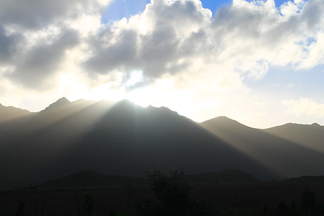
| Sunset in western Tasmania taken from the shores of Lake Burbury |
I got to Strahan with about 15 minutes to spare, drove around the town and out to Ocean Beach where I missed the sun actually setting, though the sky was still beautifully lit up with pinks, oranges, reds, and the blues of the night. I stepped out and down to the beach where I took my shoes and socks off, rolled up my jeans and walked down to the water's edge, finally allowing myself to breathe and take in the dusky views up and down the beach - Tasmania's longest. I picked up a few pebbles as keepsakes as the ocean waters washed over my feet because after all, it's not all that often you can say you've stuck your toes in the Southern Ocean. Tasmania and the southern tips of South Africa, Argentina, Chile, and New Zealand are really the only places you can do this (and Antarctica, too), and it's quite a surreal experience when you consider its vastness.
Happy with everything I was able to accomplish along the Lyell Highway, I drove back to Strahan in the dark, found my hostel - the Strahan Backpackers YHA - and got great advice from the owner for delicious fish 'n' chips, Schwoch's, in the town's centre. A delicious ending to a busy, productive, and beautiful day!

No comments:
Post a Comment