Travel Dates: October 12 and 13, 2011
Last week, after my geology conference in Minneapolis came to a close, I stuck around for one more whole free day to check out some "local" sites. My primary goal was to get out of the city and see all I could of two National Parks:
Mississippi National River and Recreation Area and the
St. Croix National Scenic Riverway. Both are river parks and the main activities are river-based: canoeing, boating, kayaking, etc. But during this time of year not many people are out canoeing, and you surely cannot experience much of the river by canoe in one day. This brings up the biggest internal struggle I have as I try and visit each of the National Parks: What counts as "being to" a specific park? My dad thinks that just driving through one of the parks counts as visiting it, but I tend to be of the mind that says you have to
do something in the park that you
cannot do anywhere else. So my challenge in visiting these two river parks was finding enough to do at each of the parks to experience part of the nature and culture they protect while remaining on land. Success was not far away.
The Mississippi National River and Recreation Area protects 72 miles of the upper reaches of the famous waterway. Luckily the city of Minneapolis is situated right on the river and has parks within its boundaries that have neat things to see all along its length. On Wednesday night, Jojo and I returned to the city's waterfront to the Mill Ruins Park, two blocks away from her apartment. These are the ruins of some of Minneapolis's oldest mills, including the ruins of the old Gold Medal Flour mill. Spanning the width of the Mississippi River at this park is the Stone Arch Bridge, an old railway bridge that has now been converted to a bike path and pedestrian bridge. Wednesday was a rainy, rainy day in the Twin Cities and though the rain stopped for a little bit, the clouds hung low over the Minneapolis skyline. Jojo and I walked across the bridge, and then re-explored the ruins down below the locks on the Mississippi.

 |
| The old Gold Medal Flour building along the Mississippi Riverfront. The ruins next to it have been preserved and now provide the walls of a back courtyard to the Mill City Museum, where the Minneapolis Historical Society is based. |
 |
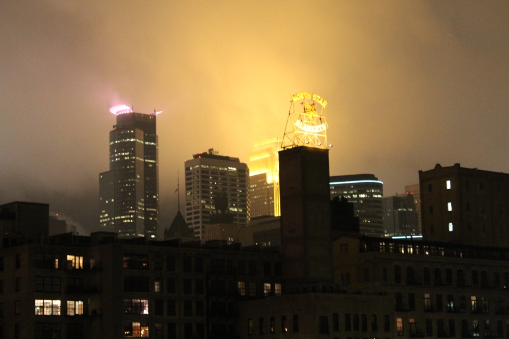
| The North Star Blankets mill sign lights up the forefront of the Minneapolis Skyline |
 |
| Looking back to Minneapolis from the middle of the Stone Arch Bridge |
 |
| Big locks along the Mississippi. Because these locks are within the confines of the National River, you can go canoeing through the lock free of charge, courtesy of the National Park Service! |
 |
| Stone Arch Bridge |
 |
| Looking over into one of the old underground waterways beneath the city. The river was diverted through these waterways to power the mills and now there is a huge network of them under the city. |
 |
| Old mill structures at the base of the Stone Arch Bridge |
 |
| Old girders at Mill Ruins Park with the new I-35W bridge illuminated in the background. The new I-35W bridge is the replacement bridge for the one that collapsed back in 2007. |
 |
| Jojo and I decided to take some pictures together, but with my DSLR camera, it was tricky. |
 |
| We managed to get the obligatory jumping shots, though. |
 |
| We got the one closer to the wall, but I thought it would be cool to come up a little bit and get a jumping shot with our shadows in the background. Our timing was less than optimal. |


Unfortunately, Jojo had to work the next day and left me to explore more of the Mississippi National River by myself. So after she left for work, I put a few things together, got in my car, and was on my way. I knew I had a lot of ground to cover but I didn't really know where I was going, so the first place I stopped was at the Coon Rapids Dam on the north side of Minneapolis. I drove across and parked on the east side of the river to check it out. Too bad for me, the visitor center there was closed and knowing this might be my only chance to get my National Park Passport Stamp for the Mississippi National River and Recreation Area, I grabbed my jacket and camera and hoofed it on over across the dam. The dam was built in 1913 at this location because the river was wide and shallow. Early settlers were known to have seen racoons scurrying out into the river to catch food - hence, the name: Coon Rapids Dam. There are very few places where you can actually walk across dams of this magnitude, so I was sure to give it a go. The dam flooded the river behind it, creating a 9-foot fall over the dam, which was used to harness the water to create power. Though the dam itself is no longer producing power, it sure is using power to remain in a functioning condition. While the dam was initially controlled by Tainter Gates (see below), all but one of these gates have been replaced by rubber inflatable walls that control the flow of water over the dam.
 |
| Coon Rapids Dam. The gate closest to the forefront of the photo is the one remaining Tainter Gate, the rest are inflated rubber walls. |
 |
| Some fall colors were in peak season on the west side of the dam |
 |
| One of the Tainter Gates was on display on the east side of the dam. The gate rotates on the pin seen in the forefront and the big curved metal surface would face upstream. Lumber was a big trade in the area when these dams were built, so blocking the river with a dam while still allowing logs to freely flow through was tricky. The Tainter Gates would pivot up and down to allow water to flow underneath of it and allow logs to pass through the dam, too. The curved surface allowed the pressure of the water to help raise and lower the gate with minimal human effort. Nevertheless, humans still had to crank the gates open and shut by hand and 100 rotations of the crank only opened the gate one inch! |
 |
| Osprey nest perched on top of a power tower outside the west dam's Visitor Center. I learned that while ospreys and eagles are competitors, they have a mutual agreement to stay out of the others' territories. |
 |
| To ensure I paid my dues and did something in the park, I took a little stroll through a grassy field under a stand of maple trees along the west bank of the river and you could see the robins flying all over the place, gathering materials to make their nests, or bathing in puddles, or pulling worms, or whatever else robins do. It was fun to see such activity! |
 |
| Looking down the mighty Mississippi River from the middle of Coon Rapids Dam. A heron rookery was established on the downstream end of the island in the middle of the photo here after a tornado struck the northern suburbs of Minneapolis in May of this year. A rescue effort moved the disturbed nests to this island, but many of the young herons were abandoned. Earlier in the season, though, herons could be seen actively coming to and going from their nests on the island. |
So, back in my car, I trended northwest from Minneapolis toward the small town of St. Croix Falls. The St. Croix National Scenic Riverway was the first river to be protected by Congress and placed under the umbrella of the National Park Service. Again, being a river park, I wasn't sure what exactly there was to do if I wasn't going to spend time on the river, so I thought the best place to find out would be the park's main visitor center at St. Croix Falls. The drive out there was beautiful and the road wound around all sorts of small lakes with houses built up all around them (not unlike the movie, Fargo - minus the woodchipper!). But once you get to the rim of the St. Croix River, you immediately descend into the gorge to St. Croix Falls. The namesake of the town is unfortunately drowned beneath a hydropower dam that is still in use, but at one time the St. Croix River would descent 55 feet in less than six miles, over a series of rapids. Those rapids are now underwater, but oh they must have been a sight to see, and maybe when it is no longer cost-effective to have that dam in place, they will remove it and expose the falls again!
I was a little out of luck with the St. Croix River because there really isn't much to do unless you are paddling down the river. But I did have a great talk with the woman running the desk in the visitor center. I noticed that on the park map, there was a zebra mussel control point further downstream. At the point, no boats are allowed upstream on the river. Sure, boats can just be transported by car upstream, but she said that they really trust the boaters to wash their boats thoroughly before doing so.
Why all the fuss? I wondered. Well, the St. Croix River is home to 42 native mussel species, all of which are still in tact and any zebra or quagga mussel populations upstream of the checkpoint are checked and removed. The woman at the front desk is on the diving team that monitors the native mussel populations. The cool thing about mussels is that they affix themselves to hard surfaces and filter nutrients out of the water. Their offspring obviously are small and are not able to feed in the same way as the adults, so the larval mussels attach themselves to the gills of specific species of fish and collect nutrients as they pass through the gills. Once the larval mussels are too big to survive in this fashion, they drop from the gills and affix themselves to the nearest hard surface. In order for the park to effectively manage their native mussel populations, they help them out by collecting larval mussels and bring them to a laboratory where they attach them to lab fish. Once the mussels are grown, the dive team will restore the adult mussels to the natural river system! I may not have been able to
do a whole lot in this park, but I did learn a bunch. It's not to say I didn't do anything, because I did take a little walk down an interpretive trail to an overlook above the St. Croix Falls hydroelectric dam.
 |
| St. Croix Falls dam and the St. Croix Falls buried somewhere beneath the water |
 |
| A sculpture depicting the River Spirit |
Though there wasn't much to see on land in the park, it was interesting to know that at this spot along the river in 1886 one of the nation's largest log jams in history was recorded. A log jam doesn't sound like much, but in 1886 over 150 million feet of timber was stuck behind the St. Croix dalles. Because the local economy was tied to the fate of this lumber, for as long as the logs were jammed the sawmills downriver saw no business and the workers had to way of providing for their families. The communities upriver, which relied on goods being transported to them by the river, starved due to the lack of supplies and food. During this particularly bad log jam, the men trying to break it up also had to watch out for "jill-poke"-ing logs - basically tree-sized rockets, fueled by increasing pressure from the river. A
photo on the National Park's website shows the extent of the 1886 log jam.
On my way out, the woman at the desk did mention that downriver is a private historic site called the
Arcola Mills that was free to the public during a month-long partnership between the National Park Service and the Arcola Mills Foundation. The mills were the first on the St. Croix River, and while they were quickly run out of business by larger mills, the original mill building and furnace are still standing, though in desperate need of repairs! It wasn't the most enthralling place I've ever been, but it gave me something more to do along the River.
 |
| The original saw mill at the Arcola Mills historic site |
 |
| Antique trinkets at the mill. Notice the tree-bark siding of the building! |
 |
| Railway trestle traversing the St. Croix River |
The afternoon was catching up to me and I wanted to get back to Minneapolis by 5pm when Jojo got out of work because the two of us had one more site to visit. BUT along my way back into Minneapolis, I tried visiting one more site: Fort Snelling. When Minnesota was first settled, this area was one of the gateways out into the wild prairie and while there are multiple stands of trees throughout the region, early accounts by soldiers seem to portray this whole area as a grassland, which is very interesting to think about. Fort Snelling was built at the confluence of the Mississippi River and the Minnesota River, a confluence that the native Dakota people thought to be the center of their creation above which was the center of their universe. Naturally, the white settlers from the east came in the mid 1800s and saw the bounteous land and wanted it. Treaties were written that would give the Dakota's land to the US and they would receive money, supplies, and a reservation in return. In typical US fashion of the time, none of the provisions were given to the Dakota people and they were robbed of their land. So they fought back, and after the Dakota war of 1862, hundreds of Dakota people were interned at Fort Snelling where many died of disease or were brutalized at the hands of the US soldiers. In one of the Dakota uprisings, 303 Dakota people were charged with the murder of innocent US civilians and each person was unfairly tried in court, and while President Lincoln saved the lives many of the tried Dakota, 38 were publicly hanged, and one who was sentenced to be hanged was given reprieve.
 |
| Fort Snelling |
I got back into Minneapolis just before Jojo got off of work so I met her at her office building, we grabbed some Chipotle burrito bowls and hopped on the Minneapolis light-rail train, and took it south to another park along the Mississippi, called Minnehaha Park. Right in Minnehaha park are the Minnehaha Falls. Jojo and I descended down to the bottom of the falls where we enjoyed our burrito bowls and then explored Minnehaha Creek down to where it joins the Mississippi River.
 |
| This house is supposed to be the first wooden-frame structure west of the Mississippi |
 |
| Minnehaha Falls from above |
 |
| Jojo and I down below Minnehaha Falls |
 |
| Cairns built in the middle of Minnehaha Creek |
 |
| Blue Heron in Minnehaha Creek stalking its prey! |
 |
| Minnehaha Falls at night, lit up by the floodlights at the rim of the falls |
Jojo and I hopped back on the light-rail and took it back into town where we met up with our friend Andrew and waited for Jojo's boyfriend to show up from the airport.
I definitely feel like I got a good taste of both the Mississippi and St. Croix River parks, but I am by no means done with them. When I left St. Croix Falls there was an old paddle-wheel boat that was running tours of the St. Croix Dalles, but I didn't have time for it then. Along both rivers, I would love to take some weekend canoe trips along the courses of the rivers, or even a really long canoe trip traversing the entire courses of them! But again, I only had one day to visit them, which is surely not enough time at all! I can't wait to get back and really experience them for the reason they were made parks in the first place: the rivers themselves!