14 October 2012
Sometimes it's nice just to get out of town for a few hours and have a change of scenery. That's exactly what I did this Saturday. My friends Quazi and Grant and I drove up, an hour north of Sydney to the little town of Woy Woy, on the other side of the bay from Killcare and Terrigal, which I visited a few weeks earlier. There isn't much to do there except have a coffee and move on, which is exactly what we did. A little bit to the south, you enter part of the Brisbane Water National Park - which is oddly enough about 700 kilometres from Brisbane. Brisbane Water NP ends where the Hawkesbury River flows into the ocean and there is a great scenic overlook at Warrah Lookout. We had to walk about 200 metres from the car to the overlook through a scabby forest with thin eucalypts and squiggly gums - which are gum trees that beetles have burrowed underneath the bark, forming these squiggly patterns.
The lookout is great! It's about 200 feet up from the water and you can get good vantage points from the fenced-in viewing area as well as non-fenced bedrock platforms. It was a bit of a gray day, and threatening rain the whole time, but you could still see up the Hawkesbury and out to Palm Beach and Barrenjoey Head on the other side of the river.
After the lookout, we drove down into the tiny town of Pearl Beach, which as a geologist, I loved because of all the different street names: Beryl Boulevard, Garnet Road, Onyx Road, Jade Place, Agate Avenue, Coral Crescent, Diamond Road, Emerald Avenue, Amethyst Avenue, Pearl Parade, Opal Court, Tourmaline Avenue, Crystal Avenue, Gem Road, Cornelian Road, and Silex Lane. Now most of these I understood because they are all names of minerals, gems, or rocks. But the last two, Cornelian and Silex, I had to look up. It turns out that cornelian is a reddish mineral in the chalcedony family which is a type of microcrystalline quartz - akin to jasper or flint. And Silex is any type of finely-ground stones with very high (or pure) silica contents. So they, too fit in with the rock/mineral/gem theme Pearl Beach has going on!
At the beach we walked out to the rocky headland of the Paul Landa Reserve and watched the tide come in a bit but then the waves started to crash a little too much, so we decided to head back before we got stranded. The sandstone bedrock out here was pretty cool too because it was chock-full of little weathering pits that created a honeycomb texture in the rocks. And between the rocks, near the water's surface, little rock crabs darted in and out of tiny fissures.
With a little lunch from the Pearl Beach Cafe in our bellies, we headed back to Sydney, refreshed!
Thursday, January 24, 2013
Australia: Blue Mountains - Mount Solitary Campout
10-11 November 2012
A week after my hike through Royal National Park, I headed west with two friends from Uni, Louise and Ben, to the Blue Mountains National Park. A few days beforehand we were talking over lunch and decided to do a one-night camp out in the mountains - which I had been to before, but either just driving through or staying at a hostel in Katoomba. But I love camping and really hadn't ever gone backcountry camping - especially since I am terrible at starting fires or doing any sort of reasonable cooking over them - so I typically just camp out of my car...
We drove up into the mountains on a Saturday, stopped in Katoomba to pick up some last minute groceries, and then parked our car near the Golden Stairs and started hiking. The thing about the Blue Mountains is that to do any bushwalking through them, you have to descend from the rim of the valleys along very steep paths, often involving steps hewn into the strong sandstone or very steep metal steps. Going down wasn't too rough, really - at least for Ben and myself. Louise's knees started acting up, though, which plagued her the rest of the trip.
Once down in the bottom of the valley, the walk is long, but fairly flat. The path took us through gumtree forests with an undergrowth choked with ferns that blocked the sunlight giving us a fairly nice cool walk. There's the saying, though, that what goes up must eventually come down, and well, the converse is true: what goes down must eventually come up. Clearly, a place called Mount Solitary is not going to be at the bottom of a valley and soon, our flat, valley-bottom walk ended and we began to climb back up through a gumtree forest with a more open undergrowth and flowering waratah - the state emblem for New South Wales. Ben said he'd seen koalas here before, and you could definitely see evidence that they live here (aka poop on the trail), so for the next hour or so, I was straining my neck up into the trees to see if I could catch a glimpse of my first koala. We had no such luck, and with a strained neck, we reached our lunch spot at the bottom of the trail ascending Mount Solitary.
After lunch, our arduous climb up a fairly steep ridge, over boulders, between rocks, and alongside sheer drop-offs began. Louise's knees were not helping her out much, but we didn't really have a choice to turn back at this point. I grabbed her pack to ease her carrying load and slowly but surely, we reached the top, stopping at a few flat lookout points along the way. But the trek to the campsite wasn't over yet. We were at the top of Mount Solitary (a plateau, really) but the campsite was on the other end of it and a little ways down the other side! But at least the hiking here was flat.
Soon enough, though, and with only another hour or two of daylight, we reached the campsite and chose our spot underneath an overhanging rock ledge nestled down in a little valley. Even though it was kind of gray and threatening all evening, a lot of hikers run into trouble here because they don't bring enough water and expect to find some they can purify once they reach the campsite. Ben had hiked this area extensively and showed me a creek bed, that even during dry spells, usually has some water left in it, but this time around it was bone dry. Good thing we had plenty of our own water with us!
We dropped our belongings off at the campsite and walked a few hundred metres to a rocky lookout facing south toward Lake Burragorang. Like all areas in the Blue Mountains we were flanked by high and steep sandstone cliffs jutting up out of the eucalypt forest below. The sun was setting and you could really get a sense of why this area is called the Blue Mountains - oils in the eucalyptus leaves gives off a haze that appears blue in the right light. We sat there for a while, taking photos, watching birds fly around the trees and branches growing out of the cliff walls below us. Eventually we headed back to the campsite where Ben and Louise started a fire, but then Ben and I (Louise's knees wouldn't let her) walked to the opposite side of the plateau and looked north toward Katoomba and the Three Sisters - a very famous and sacred Aboriginal rock formation on the opposite side of the Jamison Valley. We found a few more rocks to climb for an even higher view of the cliffs and valleys shrouded in mist, but soon headed back to camp before it got too dark.
The next morning we woke up fairly early and I took the chance to catch the sun rise over the mountains. I was hoping the valleys would be filled with morning mist like the year before, but I was out of luck this morning. Nonetheless, there were some pretty spectacular views here. Back at camp, we packed things up, but took Louise over to the rock ledge facing the Three Sisters Ben and I were at the night before, and after a few more photo ops, went back to our bags and started the trek back out.
Once again, getting down the bouldery slopes off of Mount Solitary proved to be slow-going, but we safely made it down, all accounted for into the open eucalyptus forest. Louise insisted Ben and I go ahead of her since we also wanted to climb the shorter Ruined Castle - a big rock outcrop rising off the valley floor. The climb up to the Ruined Castle was rough. It was a lot steeper than it looked, but we eventually made it to the rocks at the top and followed a group of 20 senior citizens (at least in their mid-60s for sure!) up the side of the outcrop to the top where we all took turns climbing up to the highest point. Now, I don't know what is it, but I am terrified of heights like this. It's not that I'm unsure of my footing or looking down, but I am just afraid that I'll do something stupid and loose my balance and fall off the rocks. Getting up to the top of the outcrop was fine, but it was getting from my knees onto my feet that really did me in. But after seeing these old fogies climbing up there like it was nothing, I was determined to do it - no matter how ridiculous I looked in my photos! Well, I did it, and I did look ridiculous, but what can I do about that now?
Ben and I finished up at the Ruined Castle and we made it back to the valley floor just as Louise strolled up to us - good timing, eh! We stopped for a wee bit of lunch and had fun taking photos of a curious little bird who was scrounging around for snacks. Louise lured the bird pretty close to her hands with some broken crackers, and the bird was calm enough to give it a go...once, but he he was too suspicious otherwise and nothing more than a blur in most of my photos.
Soon enough we were back at the base of the Golden Stairs and the long climb back up to the car. Again, Louise insisted we go ahead of her so we each took our own pace getting up to the top. Ben is an avid hiker and reached the car well before me and we waited a little while longer for Louise, but we all made it in one piece and all very eager to take off our hiking boots. Overall, it was a great weekend with awesome people in a beautiful national park. Can't go wrong with that!
Wednesday, January 23, 2013
Australia: Royal National Park Coastal Walk
04 November 2012
After living in Sydney for three months, and still not really knowing many people, I decided it was time to take the initiative and go do something. A while back, I'd come across a Facebook group called, Gay Camping New South Wales. It had over 1,000 members, so I figured it must be a legitimate organization but hadn't been able to attend any of their events. Finally, an event was posted advertising a 28 kilometer (17 mile) hike through Royal National Park, just south of Sydney. It was free, all access was by public transportation, and it was just one day, so without further delay, I signed myself up.
Royal National Park is the world's second oldest National Park - only second to Yellowstone National park in the US - and covers nearly 60 square miles (or half the land area of Rhode Island). National Parks in Australia are a bit different than those in the US. While the parks in each country protect large tracts of land, preserve the cultural and historical history, and support populations of rare plants and animals, the US National Parks seem to be much more restrictive in terms of what land is permitted to be administered at the National Park level. In Australia, there are a vast number of National Parks that seemingly protect nothing more than a swath of land similar to that in nearby parks. In many cases, it seems that many Australian parks were designated more for recreation than protection of a specific site, history, or environment. I am by no means belittling the National Park system in Australia because each one I've been to (and I've been to 13) offers something special - though admittedly, some offer more than others!
The plan was to meet anyone going at Central Station in a specific train car, and sure enough there ended up being about 20 guys who decided to do the hike as well! Most of the guys who showed up clearly knew each other from previous hikes, events, camp-outs, and whatnot so it was fun getting to know them a little bit on the train and hear about where they came from - which was really all over the world! I'd never really actively participated in any sort of gay social group before, so to me, it was really exciting to see that all these guys, living in Sydney from all over the world, actively got together to go on hikes, 4WD adventures, road trips, rock climbing, day walks, and just do the things guys like to do without any pretense or social activism motive.
We took the train down to Cronulla and got on a small passenger ferry that took us across Gunnamatta Bay and Port Hacking to the town of Bundeena where, after a short stroll through a neighborhood, our real walk began.
I've reiterated this time and time again, but I really cannot get over how rugged the Australian coast is. And Royal National Park is no exception - the huge, sturdy, sandstone cliffs rise up out of the ocean in a mixture of vibrant of colors and shapes, each uniquely shaped by the wind and waves. The northern end of the walk took us right over top of these cliffs, sometimes where you could just look over the edge and peer down more than 100 feet, and through shrubby bush country. In 2001, over 740,000 acres burned across the greater Sydney region - most in Lane Cove, Blue Mountains, and Royal National Park. It was part of the worst drought in 100 years and the landscape here was blackened. Though you can barely see any trace of the fires now, the trunks of many of the trees still bear those charred black marks.
Eventually, we descended on to some beautiful, sandy, wide, wind-swept beaches where fisherman were doing their best to catch a few fish and surfers were warned not to enter the waters. The trail went back up into the hills above the cliffs, and over a few creeks which were dammed at some point to create a little pool of water, almost like an infinity pool. We stopped for quick water break at Wattmolla Beach, where I was able to snap a photo of a kookaburra on a Coastal Walk sign that just begs to be in a tourist advertisement!
We kept going over the cliffs and through the bush until we walked down the big hill to Garie Beach, a long, narrow beach pinched between towering cliffs and the ocean. We stopped for a bit of lunch and some of the guys took a swim in the ocean, which I decided to opt out of since it still scares me some! But then we carried on and changed environments to kind of an open grassy section of the walk. I get the feeling it felt more open because all throughout this region of the park are these little cabins. Privately owned, for now, these cabins were the homes of families who could not afford any other lifestyle during the Great Depression. They moved out to the coast where they sustained themselves off of fish they caught and food they grew. The cabins are still used, and what better place to spend a day at the beach, though the deeds are apparently being transferred to the National Park Service if not passed down to a direct descendant of the current owners.
The last leg of the walk was through an expansive palm tree jungle that steeply angles down into the water below. The path at times takes you through a tangled knot of vines and walls of palm fronts you have to duck past, climb through, and push into if you want to keep going. Not dangerous by any means - unless you forgot your water! Finally, one last climb and a walk along a wide two-track brought us to the Otford train station where we perfectly timed a train back into the city. Everyone was tired and a bit sore, but it was a great day that a few of us then celebrated over a few beers and dinner back in Sydney.
I will definitely be revisiting Royal NP again because even though our trek was intense, we barely scratched the surface of all the things there are to do at the park, and we only saw a fraction of the rest of the park. Until then!
Sydney: Sculptures by the Sea
28 October 2012
Every year, in the middle of Spring - the Southern Hemisphere's Spring, that is - a festival out along the coastal walk between Bondi and Tamarama Beaches draws thousands of Sydney-siders and tourists alike! It is called, Sculptures by the Sea, and it is a very interesting festival. Now, I am no art critic by any means, nor do I know even the slightest about art, but sculpture art is my favorite. My all-time favorites are the big, geometric sculptures made from metal, stone, and wood. Something about the simple clean lines that tend to follow an unwritten set of rules just seems to please me. With that said, I also like abstract sculpture art, as long as it feel natural, not forced, and not overly symbolic, political, or preachy.
My friend Caitlyn (a fellow Michigan Wolverine) and I decided to see what all the fuss was about and spend a few hours one Sunday afternoon weaving our way through the throng of crowds of amateur photographers and tourists with their DSLR cameras trying to get the most abstract angle of each sculpture in the best light possible. I don't look down on these people, nor can I get frustrated by them, because let's face it, I am one of them!
Tuesday, January 22, 2013
Australia: Sydney Harbour North Head
Sometimes it's nice just to get out for a wee bit of fresh air. Wayyy back in October, I did just that. On an overcast Sunday, I decided that I would continue my coastal walking excursions, but instead of continuing on the south side of Sydney Harbour (like I did from the South Head to Bondi or Bondi to Maroubra Beaches), I wanted to give the north side of the Harbour a try. I took the ferry from Circular Quay out to Manly - a great beachside suburb - and just started walking.
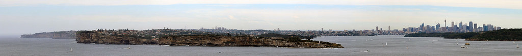 |
| Sydney Panorama |
Sydney is a fantastic city if you want to get out into a wilderness park without really leaving the city. Sydney Harbour National Park is made up of numerous parcels of land all throughout the area, most with access to the Harbour itself, and the North Head of the Harbour is no exception. As you walk, you quickly leave behind the busy suburban life and find yourself walking across small beaches at the heads of tiny inlets off the Harbour. And you see wildlife, too! One of the animals I have yet to see - though I haven't really sought it out yet - is the Sydney Harbour's population of Little Penguins. Apparently, there are only a few breeding pairs that call the Harbour their home and they all make their nests around the Manly and Fairlight suburbs. In fact, along the walking path from Manly to Fairlight, you see notices painted on the sidewalk telling you to watch out for the little penguins, which only grow to be a few tens of centimetres tall! From Manly out to the North Head, you see the signs telling you that you're in the penguin habitat, but they don't tell you where they actually are - nor will the locals divulge the nesting locations - because they want them to be protected from suburban dangers like dogs, cats, boats, and overzealous tourists - which, believe me, Sydney has and they all go out to Manly! If I were a Sydney Harbour penguin, I would be glad my nest was a secret worth keeping!
Further along, the path led back to a few houses and up to a former military training ground that is now being completely renovated into a community-led initiative focusing on the unique habitats the North Head protects. In fact, you frequently see signs warning you to keep an eye out for bandicoots - little weasel-like marsupials that were once very common throughout the Sydney area. While their populations in the suburbs are fairly healthy, the population of bandicoots in the National Park at the North Head is very very small. In fact, a hotel at the old Sydney Quarantine Station, has it written into their contract that if more than 7 bandicoots are killed by cars driving in or out, they will lose their business licence, so vehicle traffic to and from the hotel is limited in the evening, night, and morning hours when the bandicoots are most active. A colleague of mine also told me that a few years ago, a fox got in to the National Park and wreaked havoc on the bandicoot population, killing 6 bandicoots, thus reducing the gene pool by something like 20%!
So the North Head really is a little sanctuary of wilderness in the big Sydney city! At one of the welcome stations, I spoke with a volunteer who told me of the other wildlife in the park, including echidnas. Echidnas are one of the three species of monotremes - or egg-laying mammals - in the world (platypus and the long-beaked echidna are the other two). They look like mini porcupines or engorged hedgehogs, and their hind legs are twisted around to help them burrow. Anyway, the volunteer told me that they are not uncommon sightings in the park, but I was highly unlikely to see one. And with that, I had a goal for the day!
Continuing on along a raised metal-grate walkway (which is such a great idea for national parks to have because plants can grow under it, animals can pass underneath, and the only damage to the land are the post-holes for the walkway supports), I headed toward the view point at the very tip of the Harbour.
The amazing thing about the Australian coast around Sydney is that you have your nice wide sandy beaches, but between them are these massively huge sandstone cliffs that drop into the ocean and are eroded by the salty waves below. Just like on the South Head, there are battlements built up all around the North Head to protect Sydney Harbour during the World Wars. Many of the constructions still remain today and are built in to the scenic lookouts.
The amazing thing about the Australian coast around Sydney is that you have your nice wide sandy beaches, but between them are these massively huge sandstone cliffs that drop into the ocean and are eroded by the salty waves below. Just like on the South Head, there are battlements built up all around the North Head to protect Sydney Harbour during the World Wars. Many of the constructions still remain today and are built in to the scenic lookouts.
Being October, it was a little late for the main right and sperm whale migrations, but at one of the lookouts, I noticed that a Sydney whale-watching boat was out in the ocean and since it guarantees its customers to see a whale, I figured I'd see if I could see anything. I had no luck, but a man who was there with his family was more patient than me, and sure enough, he saw the tell-tale sign of a whale's presence: the steam from the blowhole! We determined there were two whales, very far away, and they would only come up every five minutes or so, so it seemed like forever waiting for them to come back to the surface. Thankfully, I had my DSLR camera with the telephoto lens and while you can't really see the whales in the photo, you can see the breaking water and blowing mist as they breached. And then, wouldn't you believe it, just beneath the cliffs below us a small pod of dolphins was spotted and I watched them for a good ten minutes before they turned and went in a different direction.
The view of the city and the South Head from the lookout is fantastic, even on a gray day, like when I was there. You really get a sense of just how big Sydney Harbour is, how rough its coast is, and how green and beautiful the city is on the hills surrounding the Harbour. I started to head back to the path, because I wanted to find the correct trail down to Manly Beach, and just before I got to the parking lot for the North Head lookout, I saw a few people gathered on the walkway looking at something. I got a little closer and was surprised and excited to see an echidna digging and scratching in the dirt just off the sidewalk, looking for his dinner. They really are bizarre looking little guys! He took no notice of our small crowd and maybe even posed for a few camera shots! I felt lucky to have been able to see another Australian animal that many Australians haven't seen outside of the zoo (and I've seen 5 of them!).
I got back on the path and saw a sign pointing toward some rare cliff-top swamps or bogs that are just perched on top of the flat sandstone and decided to take a little detour. The walk was great and almost no one else was on it. The metal walkway seemed to hover over these perfectly still ponds while dragonflies and birds zoomed around.
I got back on the path and saw a sign pointing toward some rare cliff-top swamps or bogs that are just perched on top of the flat sandstone and decided to take a little detour. The walk was great and almost no one else was on it. The metal walkway seemed to hover over these perfectly still ponds while dragonflies and birds zoomed around.
Soon enough, though, I was back on the trail and working my way over to Manly Beach. The sun was beginning to get low in the sky, turning it a nice pink color, but off in the distance, well north of Sydney I could see the rising smoke of controlled fire-burns being lit to limit the advance of a real bush fire, should one occur during the summer months. A few years back, a big bush fire did burn its way through Lane Cove National Park right out near Macquarie University, where I study, so the chances of a fire coming close to the city are very real and all precautions in the outer suburbs are taken to prevent loss of life and property.
Manly, the North Head, and the ferry ride back into the city are some of my favorite spots in Sydney. This walk was the last time I was out that way and after writing this, I have an urge to make another visit soon!
Monday, January 21, 2013
Australia: Fieldwork on the Tablelands of New South Wales
**I am way behind in updating my blog. I have about 10 mini-trips that I need to write about, so here we go with the first**
In August, I moved down to Australia from Glasgow, Scotland, to start the next stage of my PhD, studying landscape change of the Tablelands of southeastern Australia. The crucial part of my research is based on the samples I collect in the field, which I was finally able to start doing in October 2012, after a preliminary trip in August to scout out potential sampling sites.
The first trip in August was fairly relaxed. My supervisor from Glasgow came down for the week and we were joined by my supervisor from Australia and a local colleague of my Glasgow Supervisor's for a few days each. The Tablelands is a landscape dominated by rolling hills - sometimes mountainous - with gum tree forests and flat open grazing pastures in the valley bottoms. They spread a good distance, over 500km from north of Bathurst to south of Cooma, and almost 200km wide from Goulburn to Gundagai - roughly. When the European Australians first arrived to the Tablelands, the valley bottoms were soggy swampy meadows with sometimes large ponds in them. Water flowed through the landscape, though not in defined channels. With the introduction of grazing agriculture came lots of deforestation, which, paired with Australia's variable drought-dominated and flood-dominated climate regimes, led to the incision of these waterways into the valley bottoms, carving out deep gullies. As gullies were eroded in some parts of the landscape, the sediment released from them was deposited further downstream, covering the swampy meadows. Whether the cause of this widespread landscape degradation came from introduced grazing agriculture, from natural cyclical processes that happened to start at the same time as European grazing, or from fire-agricultural methods employed by Aboriginal Australians, we cannot be sure, and that is the purpose of my research.
So fieldwork involved me, and one of a handful of great field assistants, going into these gullies and collecting sediment samples from the gully walls and later I will determine burial ages for the sediment which will help me interpret when widespread gullying and sediment deposition on the Tablelands began.
While this region of Australia is arguably not all that scenic - there are no rough coasts, rainforests, mountains, or outback deserts - the rolling hills are beautiful and we frequently drove in and out of Australian bush land which provided plenty of opportunities to see amazing Australian wildlife.
In August, I was more focused on tuning my eyes to what was happening on the landscape. At one of our first stops, near Bevendale, we visited a site my Glasgow supervisor had previously worked on. A few years ago, to get to the landowners' house - we always asked for permission to gain access to land and let them know we were there - you'd just drive over a bridge spanning a 5 metre-deep gully. My supervisor was shocked to see when we got there that the bridge had been totally wiped out. We forded the stream and when we found the homeowners, they told us that the bridge had been washed out by the biggest flood they'd experienced. The water level rose up those 5 metres to the bridge and just plucked it up, carrying it downstream. This was not in any sort of gorge or steep landscape, nor was the upstream area all that large, but seasonally, this part of Australia can be subject to massive floods!
A few days later we visited another site along a stream called, Birchams Creek, and it ended up being one of my favorite sites that I returned to a few times. At this site, just 40 minutes outside of Canberra, the Australian capitol city, I was guaranteed to see at least 20 (sometimes upwards of 50+) kangaroos! Australians kind of see kangaroos like we, in Michigan, see deer. They are everywhere and often end up crushed by cars on the side of the road. But here, back in the countryside, they were everywhere and each time I visited, I would see them hopping up and down the hills, in and out of the paddock fences, and sleeping under trees in the middle of the day. So cute to see, too, when the little joeys are sticking their heads out of the mothers' pouches!
Overall, August field work was kind of dull - more driving than work. But I did get one experience most Australians do not: I was in the middle of a snowstorm! It was the second to last day of field work and we'd kind of exhausted the options of places to visit, so my supervisors and I took a drive to a peat bog on the southern slopes of the Brindabella Range which makes up the border between the Australian Capital Territory and New South Wales. We drove up through the mountains through Namadgi National Park, through a snow gum forest, and stopped at a scenic overlook where you could see the flat valley bottom below, surrounded by steep mountains. It was windy and cold, so we didn't stay long and kept driving down the other side of the mountains. We stopped at the Yaouk Peat Bog on the other side of the mountains and discussing how we might use it in my research and while we were there it started to snow. It wasn't really a blizzard, that would be exaggerating, but there were plenty of small specks of snow falling all around us as we got back into the car and drove toward Adaminaby for lunch. By the time we arrived and sat down in the small town's cafe, it was near blizzard conditions - big wet flakes of snow were swirling around outside and even the woman who ran the cafe ran outside with her camera because she had never seen anything like it! It cleared up enough as we left for me to see the Big Trout (Australia, like the US, is proud of their BIG roadside attractions) but then we drove back into the storm as we headed to Cooma and up to Queanbeyan.
October eventually rolled around and it was time to head back out into the field to actually collect some samples. I had two field assistants lined up to help me out over the two and half weeks of work and they were both great (we will call the first Britney and the second Tracy). Both were gung-ho undergrads who wanted to get experience with field work and couldn't have been better suited for the work. Britney was more interested in biology but hadn't had any field experience before and was curious to know what it was like and while I got excited about sediment and rocks she got excited about all the different animals we came across from sheep and horses to cats and puppies. Tracy was a seasoned environmental science undergrad who had a keen eye for approaching geologic problems and often kept me on track for what I was supposed to be doing. Both were Australians, which was important for me because I would be talking to landowners, asking their permission to go on their land, and knowing how suspicious Americans can be about people coming on their property, I didn't want to say the wrong thing or ask the wrong question, so it was good to have Britney and Tracy as field assistants. Also, both had excellent taste in music which was important for the long car rides.
Britney and I went into the field first, sticking around the Goulburn area. We visited a few streams nearby and collected samples, and scoped out a few more sites I could potentially come back to. But after a few days, Britney had to be back in Sydney so we drove the two hours back, I stayed the night in the city, and then picked up Tracy the next morning and drove back out to the field. Tracy and I went a bit further south, more toward Lake George - an inland lake with a large surface area (so it looked big) but a small depth of only 2 metres (so there wasn't much water). While at one of my sites, situated right next to a wide and long section of the stream that was more like a pool, we saw a few splashes and this little brown-backed critter with its nose just sticking out of the water, zig-zagging back and forth across the pool, spending a lot of time under the banks where sticks and weeds were all mashed together. It was mid-day, and though we both knew that platypuses are typically out in the evening and at night, we were sure that is what we saw! It was difficult getting photos of the animal (which I desperately wanted!) and when we asked some landowners further downstream if they ever saw any platypuses we were discouraged to hear that they'd only seen one platypus, thirty years before. They tried convincing us we saw a water rat, but the animal we saw did not have the white fur on its back like a water rat would have had and water rats swim on the surface whereas this critter spent most of its time underwater. Though unconfirmed, we decided that we had been some of the lucky few Australians who have seen the elusive platypus out in the wild and I got to check another Aussie animal off my list!
Tracy couldn't stay more than three days in the field, so off we drove, back to Sydney, where the next morning I exchanged field assistants again and Britney and I headed back toward Goulburn, but kept driving and eventually steered north toward Cowra. The next few days were fairly uneventful, and wet. Also, I was getting frustrated because I hadn't been to this part of the Tablelands before so I didn't really know where to go to find appropriate sample sites, so there was a lot of driving around. I felt so bad for Britney because she was so patient and tried to be helpful, but sometimes my stress got the better of me. But we got some good samples over those few days and met some friendly landowners who couldn't have been more helpful for us. It wasn't long before a few exciting things happened. We were driving in the hills around Mandurama and off in the distance, on the high hilltops, we could see snow. Britney had never seen real snow in her life before so I drove back up into the hills until we crossed the snow line and stopped the car. Now, I've been in real blizzards, buried under feet of snow, and spent so much time in good snow that I was pretty unimpressed by the light dusting of white we saw on the ground, but it was real fun to watch Britney get out and stomp around in it, packing it into a little snowball and throwing it, and I got a good kick out of her answer when I asked, "Well, what do you think?" and she responded, "It's so WET!" Haha. It was a great moment and on the way back down the hill we crossed paths with a rural postman who was also stopping to take some photos of the snow. It was definitely a rarity for that time of year and a rarity for Australia in general! The next day we got a bit more excitement when I saw something unusual in one of the grazing paddocks - a small flock of weirdly gangly, 8-foot tall, dinosaur-like birds was strutting across the field a good distance away from the road, but I knew what they were immediately: Emus! I pulled over and grabbed my camera to take about one million photos of them. I wanted them to come closer and even though they didn't, we watched them for a good ten minutes or so!
And then November came around. It was time for me to head back into the field and collect some samples from sites I hadn't focused much time on before. I started off on my own this time, driving through the Blue Mountains north, back toward Manduarama to a site along Grubbenbun Creek I'd been to before, but didn't take samples. After Grubbenbun, the landowners gave me directions for the back-road route to get to Crookwell. It was already the evening and the two-hour drive took me through some beautiful dirt roads through tiny hill-towns with names like Thalaba, Abercrombie River, Peelwood, and Trunkey Creek. I would be sampling the next day north of the town of Laggan, so I stopped at the site to see if I could introduce myself to the landowners. The old couple who answered the door were so nice and and man had been living on the land since his family settled down here, the first European Australians to graze the land, way back in the 1830s! The next few days were standard work days. I'd go to the creek, clear off a fresh sediment surface from the gully wall and remove my sediment samples. After Laggan, I drove down to Queanbeyan where my Glasgow supervisor's former colleague, Jane, lived. Jane had been out with us for a few days in August and was happy to help me over the weekend. We went back to the Birchams Creek site, where again we saw dozens of kangaroos on the hillsides, and we also revisited a site on the western boundary of the Australian Capital Territory. Jane is a geologist and has had a bit of experience working on the Australian landscapes, so it was fantastic to work with someone who brought a professional geologist's perspective to my research and helped guide my field work strategy to be able to collect samples that would best answer my research questions.
But Jane could only help out over the weekend, so Monday I worked by myself again, and on Tuesday, I drove into Canberra to pick up my next field assistant, Drew. Drew had just finished his Honors Thesis on river erosion and sedimentation and happily, for me, was willing to give up a few days of surf to come dig around in the mud and dirt with me! I had a few hours before Drew arrived, though, so I checked out the Australian War Memorial on the outskirts of the city. Canberra isn't much as far as cities go, but it is chock full of museums! I only had about ten minutes in the War Memorial museum, but I will definitely be going back to spend more time there!
I retrieved Drew and we headed south for an hour or so and turned off down a long dirt road. I wanted to collect a different type of sample, mud from the valley bottom of a modern swampy meadow, one that hadn't been gullied through or buried yet. We saw a house that looked like they might own a bit of land and as we drove up, dog started running toward us and a very imposing man stood on the porch of the house. We exchanged hellos as we walked toward each other, and the mood changed immediately. This guy and his wife had just moved out into the country from a small town nearby and were in the process of building a Sabbatical Recording Studio in some of the sheds out back. I forget what his name was - MC something-or-other - but MC was really into his music and worked with local and international recording artists and he and his wife wanted to be surrounded by peace and quiet while working with artists who wanted to get out of your typical city sound studio and into a more relaxing setting for recording their music. They gave us a tour of their recording studio, which was a work in progress. And though I believed their story and liked MC's enthusiasm for music, we were still a little wary to follow them into these sheds where the studio was being built, though MC was so excited to show us the sound-proof rooms and a bathroom with a microphone built into the shower head so the artists could sing before their session and get rid of the jitters. I was actually pretty impressed and excited for their business. It was just such a cool combination of beautiful land, quiet scenery, and high-tech modern recording equipment! Though I do have to say, Drew and I both felt like we'd just stepped onto the set of a real-life horror movie when they took us on the tour of their studio. "Sure, come check out these sound-proof rooms. I won't knock you out with this hammer we're using to install the keyboard. Wait 'til you see the sound booth shed!" But really, MC and his wife were great people to chat with!
Drew and I carried on with our work, and the next day drove south from Cooma to a little town called Dalgety and turned down a road that ran a 20 kilometre loop through grazing country. We were headed to a town on my map called Jimenbuen, which was at the far end of the loop road. The road we were on went from being paved to dirt and eventually it turned into a small two-track that wound through wide open grazing pastures. Eventually, though, the road stopped and we were definitely not in any sort of town but in front of a creepy old house. It didn't look like anyone was home and it didn't seem to be near anything else, so we decided we must have taken a wrong turn somewhere and started to head back. While on that little two-track, though, we spooked three emus which were only about 30 metres away! Drew told me to stop the car and roll down the window. Apparently emus are notoriously curious and sure enough, they started toward the car. I couldn't believe just how massive these birds are! They're at least 8 feet tall, with spindly legs, and a relatively small body compared to their long necks which are covered with thick, tufty feathers. Honestly, they just look top-heavy and like with any step they will tip over! They got bored with us after just a few minutes and took off in the opposite direction, but it was so cool to be so close to these amazing birds out in the wild!
November was a warm month to be doing field work in and the days were hot and sweaty and Drew and I were bothered by flies wherever we went those few days, but as quickly as field work started, it ended for the year and we drove back to Sydney after a few days in Cooma. So now, with samples in hand, I was ready to start getting some data back from my samples and the story of when landscape change started on the Tablelands was beginning to take shape. The story continues, but I am waiting to be trained in the laboratory to process the rest of the samples, and while I have a few weeks of field work in the books for 2013, nothing yet is planned.
In August, I moved down to Australia from Glasgow, Scotland, to start the next stage of my PhD, studying landscape change of the Tablelands of southeastern Australia. The crucial part of my research is based on the samples I collect in the field, which I was finally able to start doing in October 2012, after a preliminary trip in August to scout out potential sampling sites.
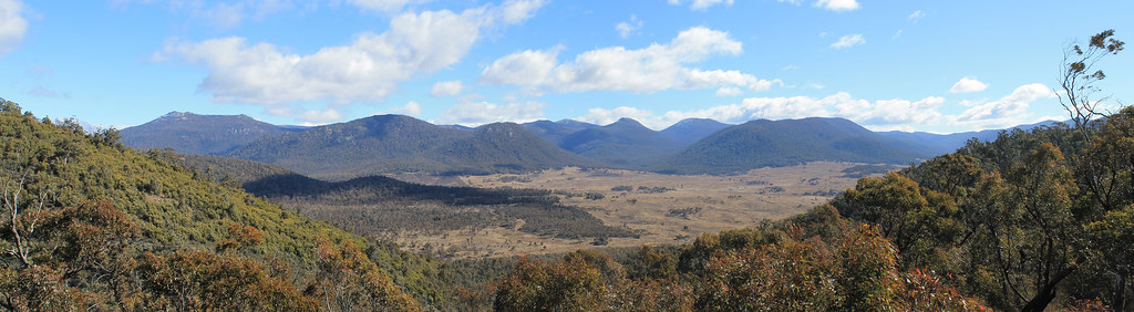 |
| View from the lookout in Namadgi National Park in the Australian Capital Territory |
The first trip in August was fairly relaxed. My supervisor from Glasgow came down for the week and we were joined by my supervisor from Australia and a local colleague of my Glasgow Supervisor's for a few days each. The Tablelands is a landscape dominated by rolling hills - sometimes mountainous - with gum tree forests and flat open grazing pastures in the valley bottoms. They spread a good distance, over 500km from north of Bathurst to south of Cooma, and almost 200km wide from Goulburn to Gundagai - roughly. When the European Australians first arrived to the Tablelands, the valley bottoms were soggy swampy meadows with sometimes large ponds in them. Water flowed through the landscape, though not in defined channels. With the introduction of grazing agriculture came lots of deforestation, which, paired with Australia's variable drought-dominated and flood-dominated climate regimes, led to the incision of these waterways into the valley bottoms, carving out deep gullies. As gullies were eroded in some parts of the landscape, the sediment released from them was deposited further downstream, covering the swampy meadows. Whether the cause of this widespread landscape degradation came from introduced grazing agriculture, from natural cyclical processes that happened to start at the same time as European grazing, or from fire-agricultural methods employed by Aboriginal Australians, we cannot be sure, and that is the purpose of my research.
So fieldwork involved me, and one of a handful of great field assistants, going into these gullies and collecting sediment samples from the gully walls and later I will determine burial ages for the sediment which will help me interpret when widespread gullying and sediment deposition on the Tablelands began.
While this region of Australia is arguably not all that scenic - there are no rough coasts, rainforests, mountains, or outback deserts - the rolling hills are beautiful and we frequently drove in and out of Australian bush land which provided plenty of opportunities to see amazing Australian wildlife.
In August, I was more focused on tuning my eyes to what was happening on the landscape. At one of our first stops, near Bevendale, we visited a site my Glasgow supervisor had previously worked on. A few years ago, to get to the landowners' house - we always asked for permission to gain access to land and let them know we were there - you'd just drive over a bridge spanning a 5 metre-deep gully. My supervisor was shocked to see when we got there that the bridge had been totally wiped out. We forded the stream and when we found the homeowners, they told us that the bridge had been washed out by the biggest flood they'd experienced. The water level rose up those 5 metres to the bridge and just plucked it up, carrying it downstream. This was not in any sort of gorge or steep landscape, nor was the upstream area all that large, but seasonally, this part of Australia can be subject to massive floods!
A few days later we visited another site along a stream called, Birchams Creek, and it ended up being one of my favorite sites that I returned to a few times. At this site, just 40 minutes outside of Canberra, the Australian capitol city, I was guaranteed to see at least 20 (sometimes upwards of 50+) kangaroos! Australians kind of see kangaroos like we, in Michigan, see deer. They are everywhere and often end up crushed by cars on the side of the road. But here, back in the countryside, they were everywhere and each time I visited, I would see them hopping up and down the hills, in and out of the paddock fences, and sleeping under trees in the middle of the day. So cute to see, too, when the little joeys are sticking their heads out of the mothers' pouches!
Overall, August field work was kind of dull - more driving than work. But I did get one experience most Australians do not: I was in the middle of a snowstorm! It was the second to last day of field work and we'd kind of exhausted the options of places to visit, so my supervisors and I took a drive to a peat bog on the southern slopes of the Brindabella Range which makes up the border between the Australian Capital Territory and New South Wales. We drove up through the mountains through Namadgi National Park, through a snow gum forest, and stopped at a scenic overlook where you could see the flat valley bottom below, surrounded by steep mountains. It was windy and cold, so we didn't stay long and kept driving down the other side of the mountains. We stopped at the Yaouk Peat Bog on the other side of the mountains and discussing how we might use it in my research and while we were there it started to snow. It wasn't really a blizzard, that would be exaggerating, but there were plenty of small specks of snow falling all around us as we got back into the car and drove toward Adaminaby for lunch. By the time we arrived and sat down in the small town's cafe, it was near blizzard conditions - big wet flakes of snow were swirling around outside and even the woman who ran the cafe ran outside with her camera because she had never seen anything like it! It cleared up enough as we left for me to see the Big Trout (Australia, like the US, is proud of their BIG roadside attractions) but then we drove back into the storm as we headed to Cooma and up to Queanbeyan.
October eventually rolled around and it was time to head back out into the field to actually collect some samples. I had two field assistants lined up to help me out over the two and half weeks of work and they were both great (we will call the first Britney and the second Tracy). Both were gung-ho undergrads who wanted to get experience with field work and couldn't have been better suited for the work. Britney was more interested in biology but hadn't had any field experience before and was curious to know what it was like and while I got excited about sediment and rocks she got excited about all the different animals we came across from sheep and horses to cats and puppies. Tracy was a seasoned environmental science undergrad who had a keen eye for approaching geologic problems and often kept me on track for what I was supposed to be doing. Both were Australians, which was important for me because I would be talking to landowners, asking their permission to go on their land, and knowing how suspicious Americans can be about people coming on their property, I didn't want to say the wrong thing or ask the wrong question, so it was good to have Britney and Tracy as field assistants. Also, both had excellent taste in music which was important for the long car rides.
Britney and I went into the field first, sticking around the Goulburn area. We visited a few streams nearby and collected samples, and scoped out a few more sites I could potentially come back to. But after a few days, Britney had to be back in Sydney so we drove the two hours back, I stayed the night in the city, and then picked up Tracy the next morning and drove back out to the field. Tracy and I went a bit further south, more toward Lake George - an inland lake with a large surface area (so it looked big) but a small depth of only 2 metres (so there wasn't much water). While at one of my sites, situated right next to a wide and long section of the stream that was more like a pool, we saw a few splashes and this little brown-backed critter with its nose just sticking out of the water, zig-zagging back and forth across the pool, spending a lot of time under the banks where sticks and weeds were all mashed together. It was mid-day, and though we both knew that platypuses are typically out in the evening and at night, we were sure that is what we saw! It was difficult getting photos of the animal (which I desperately wanted!) and when we asked some landowners further downstream if they ever saw any platypuses we were discouraged to hear that they'd only seen one platypus, thirty years before. They tried convincing us we saw a water rat, but the animal we saw did not have the white fur on its back like a water rat would have had and water rats swim on the surface whereas this critter spent most of its time underwater. Though unconfirmed, we decided that we had been some of the lucky few Australians who have seen the elusive platypus out in the wild and I got to check another Aussie animal off my list!
Tracy couldn't stay more than three days in the field, so off we drove, back to Sydney, where the next morning I exchanged field assistants again and Britney and I headed back toward Goulburn, but kept driving and eventually steered north toward Cowra. The next few days were fairly uneventful, and wet. Also, I was getting frustrated because I hadn't been to this part of the Tablelands before so I didn't really know where to go to find appropriate sample sites, so there was a lot of driving around. I felt so bad for Britney because she was so patient and tried to be helpful, but sometimes my stress got the better of me. But we got some good samples over those few days and met some friendly landowners who couldn't have been more helpful for us. It wasn't long before a few exciting things happened. We were driving in the hills around Mandurama and off in the distance, on the high hilltops, we could see snow. Britney had never seen real snow in her life before so I drove back up into the hills until we crossed the snow line and stopped the car. Now, I've been in real blizzards, buried under feet of snow, and spent so much time in good snow that I was pretty unimpressed by the light dusting of white we saw on the ground, but it was real fun to watch Britney get out and stomp around in it, packing it into a little snowball and throwing it, and I got a good kick out of her answer when I asked, "Well, what do you think?" and she responded, "It's so WET!" Haha. It was a great moment and on the way back down the hill we crossed paths with a rural postman who was also stopping to take some photos of the snow. It was definitely a rarity for that time of year and a rarity for Australia in general! The next day we got a bit more excitement when I saw something unusual in one of the grazing paddocks - a small flock of weirdly gangly, 8-foot tall, dinosaur-like birds was strutting across the field a good distance away from the road, but I knew what they were immediately: Emus! I pulled over and grabbed my camera to take about one million photos of them. I wanted them to come closer and even though they didn't, we watched them for a good ten minutes or so!
And then November came around. It was time for me to head back into the field and collect some samples from sites I hadn't focused much time on before. I started off on my own this time, driving through the Blue Mountains north, back toward Manduarama to a site along Grubbenbun Creek I'd been to before, but didn't take samples. After Grubbenbun, the landowners gave me directions for the back-road route to get to Crookwell. It was already the evening and the two-hour drive took me through some beautiful dirt roads through tiny hill-towns with names like Thalaba, Abercrombie River, Peelwood, and Trunkey Creek. I would be sampling the next day north of the town of Laggan, so I stopped at the site to see if I could introduce myself to the landowners. The old couple who answered the door were so nice and and man had been living on the land since his family settled down here, the first European Australians to graze the land, way back in the 1830s! The next few days were standard work days. I'd go to the creek, clear off a fresh sediment surface from the gully wall and remove my sediment samples. After Laggan, I drove down to Queanbeyan where my Glasgow supervisor's former colleague, Jane, lived. Jane had been out with us for a few days in August and was happy to help me over the weekend. We went back to the Birchams Creek site, where again we saw dozens of kangaroos on the hillsides, and we also revisited a site on the western boundary of the Australian Capital Territory. Jane is a geologist and has had a bit of experience working on the Australian landscapes, so it was fantastic to work with someone who brought a professional geologist's perspective to my research and helped guide my field work strategy to be able to collect samples that would best answer my research questions.
But Jane could only help out over the weekend, so Monday I worked by myself again, and on Tuesday, I drove into Canberra to pick up my next field assistant, Drew. Drew had just finished his Honors Thesis on river erosion and sedimentation and happily, for me, was willing to give up a few days of surf to come dig around in the mud and dirt with me! I had a few hours before Drew arrived, though, so I checked out the Australian War Memorial on the outskirts of the city. Canberra isn't much as far as cities go, but it is chock full of museums! I only had about ten minutes in the War Memorial museum, but I will definitely be going back to spend more time there!
I retrieved Drew and we headed south for an hour or so and turned off down a long dirt road. I wanted to collect a different type of sample, mud from the valley bottom of a modern swampy meadow, one that hadn't been gullied through or buried yet. We saw a house that looked like they might own a bit of land and as we drove up, dog started running toward us and a very imposing man stood on the porch of the house. We exchanged hellos as we walked toward each other, and the mood changed immediately. This guy and his wife had just moved out into the country from a small town nearby and were in the process of building a Sabbatical Recording Studio in some of the sheds out back. I forget what his name was - MC something-or-other - but MC was really into his music and worked with local and international recording artists and he and his wife wanted to be surrounded by peace and quiet while working with artists who wanted to get out of your typical city sound studio and into a more relaxing setting for recording their music. They gave us a tour of their recording studio, which was a work in progress. And though I believed their story and liked MC's enthusiasm for music, we were still a little wary to follow them into these sheds where the studio was being built, though MC was so excited to show us the sound-proof rooms and a bathroom with a microphone built into the shower head so the artists could sing before their session and get rid of the jitters. I was actually pretty impressed and excited for their business. It was just such a cool combination of beautiful land, quiet scenery, and high-tech modern recording equipment! Though I do have to say, Drew and I both felt like we'd just stepped onto the set of a real-life horror movie when they took us on the tour of their studio. "Sure, come check out these sound-proof rooms. I won't knock you out with this hammer we're using to install the keyboard. Wait 'til you see the sound booth shed!" But really, MC and his wife were great people to chat with!
Drew and I carried on with our work, and the next day drove south from Cooma to a little town called Dalgety and turned down a road that ran a 20 kilometre loop through grazing country. We were headed to a town on my map called Jimenbuen, which was at the far end of the loop road. The road we were on went from being paved to dirt and eventually it turned into a small two-track that wound through wide open grazing pastures. Eventually, though, the road stopped and we were definitely not in any sort of town but in front of a creepy old house. It didn't look like anyone was home and it didn't seem to be near anything else, so we decided we must have taken a wrong turn somewhere and started to head back. While on that little two-track, though, we spooked three emus which were only about 30 metres away! Drew told me to stop the car and roll down the window. Apparently emus are notoriously curious and sure enough, they started toward the car. I couldn't believe just how massive these birds are! They're at least 8 feet tall, with spindly legs, and a relatively small body compared to their long necks which are covered with thick, tufty feathers. Honestly, they just look top-heavy and like with any step they will tip over! They got bored with us after just a few minutes and took off in the opposite direction, but it was so cool to be so close to these amazing birds out in the wild!
November was a warm month to be doing field work in and the days were hot and sweaty and Drew and I were bothered by flies wherever we went those few days, but as quickly as field work started, it ended for the year and we drove back to Sydney after a few days in Cooma. So now, with samples in hand, I was ready to start getting some data back from my samples and the story of when landscape change started on the Tablelands was beginning to take shape. The story continues, but I am waiting to be trained in the laboratory to process the rest of the samples, and while I have a few weeks of field work in the books for 2013, nothing yet is planned.
Subscribe to:
Posts (Atom)
