Showing posts with label Airplanes. Show all posts

Saturday, May 25, 2013

Australia: Tasmania's Lyell Highway from Hobart to Strahan

Travel Date: 24 April 2013

Back in early April, while everyone in Australia was taking their Easter Friday and Monday off of work, I was grading assignments and in my lab working, being the diligent PhD student I am! But I needed a getaway, and part of my excuse for working over Easter was that I'd previously purchased a round-trip flight down to Tasmania for five days in late April.

I needed a break. After four solid months of slogging through lab work, research, writing, reading, and teaching, I needed to step off the Sydney merry-go-round or go insane. Having moved to Glasgow in winter of 2012, then to Sydney in August, I pretty much had a year of winter immediately followed by the Australian summer with no change of seasons to speak of and definitely no Fall, which is my favourite. Sure I got a little taste of Michigan Football last September-November, but no pumpkin spiced lattes, no leaves changing colour, nothing. But the nice thing about Tasmania is that it is as far south  from the Equator as Michigan and Vermont are north of it, and April in Tassie would be the same as October in the northern hemisphere. In other words, it was Fall!

Fall Colours on the River Derwent
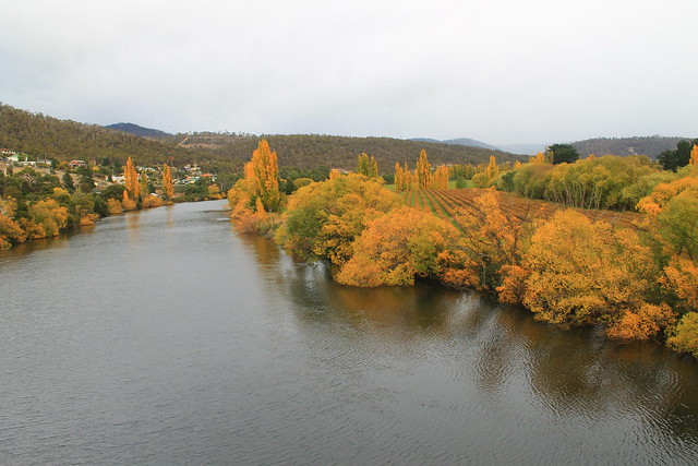
Fall colours along the River Derwent in New Norfolk
I arrived in Hobart, Tasmania's capital, at 8am, picked up my rental car - a wee Suzuki Swift which I really ended up liking! - and started off down the Lyell Highway. My goal was to get to the small town of Strahan on the western coast of Tasmania, but I also wanted to see as much as possible. My initial plan was to drive north toward Launceston and then west to Cradle Mountain before arriving late in Strahan, but took the advice of locals on the r/tasmania subreddit who thought I might be better off taking the shorter route and actually experience it. They were right.

My first stop wasn't planned until Lake St. Clair in the Tasmanian central highlands, but after picking up coffee in New Norfolk - a town originally set up as a new homebase for Australian convicts stationed out at the soon to be abandoned Norfolk Island camp in the Tasman Sea - I crossed the River Derwent and had to stop because the trees along the riverbanks were on fire with autumnal colours! It was beautiful! From what I'd heard about Tasmania and the Tasmanian culture of environmental awareness and power of purchasing locally, I imagined it to be much like Vermont in the US. The similarities, I would find out, were uncanny, and the trees along the river were just the beginning. I do have to say, though, that this is the only time I've been happy seeing invasive species; you see, no native Australian trees change colour with the seasons, only the imported species from Europe and North America!

Continuing along through pastoral farming/grazing communities, the Lyell Hwy suddenly started its ascent into mountains and the roads became narrow, steep, and windy (and windy)! I passed some of Tasmania's many hydroelectric facilities in Terraleah and the road then spit me out onto the highland plateaus just east of the central Highlands.

Tasmania's central highlands and the entire southwest quadrant of the island are all preserved as National Parks, most of which make up the Tasmanian Wilderness World Heritage Area, and while you can access many places in those parks, the majority of it is left as a natural wilderness for your experienced outdoor exploration! The famed Overland Track is one of the World's best wilderness walks right through Cradle Mountain-Lake St. Clair National Park,and something I hope to do before leaving Australia.

My first planned stop, though, was at an artistic site just east of Lake St. Clair called The Wall in the Wilderness. I'd heard about this artist who is carving out scenes from Tasmania's varied industrial, cultural, and environmental histories in huge panels of wood. In my mind I imagined it to be like a huge detailed collage of various moments that I could learn a lot from. Surely I wouldn't be disappointed. But when I walked up to the door there was a big sign saying something along the lines of:
No cameras allowed! Personal photographs do not capture the essence of my artistic vision when taken in the wrong light. When I have people throwing punches at me for not allowing them to take photos it gives me the right ban all cameras. My art is self-funded and I will decide what I will and will not allow.
Well, that kind of made me stop in my tracks and think, "Wow, what an ass." But not knowing what this guy has gone through, I returned my camera to my car. I thought the $10 admission fee was a bit steep, especially with no student discounts, but I gave them the benefit of the doubt. The building was cold and dimly-lit and in the central hall was the Wall. It was impressive to look at. Dozens of wooden panels of Huon Pine were hanging from a central wall, the majority of which had images of Tassie history hand-carved into the wood: hydro power, convict history, the extinct Tasmanian tiger, and natural scenery - and those that weren't yet carved had the pencil marks on them showing what they would eventually be. It was neat, and the artist is obviously a talented wood-carver, but was it comparable to Michelangelo's painting of the Sistene Chapel (as the Wall's website claims)? No, not in the least bit! Maybe it was the sour taste left in my mouth from not being able to take my camera in, or the tone with which that message was conveyed, but I thought the wall was impressive in size only. There were no information placards describing what I was looking at, but I could buy a book for another $20 to learn about each panel. Essentially, I thought this piece of art was a waste of time and money and I do not encourage anyone to visit. You'll just be nickel-and-dimed out of $10 and with nothing given in return. It's not educational and not all that spectacular when all is said and done. And even though I paid to see the Wall - thus paying for the future work on the wall - I didn't even get to take a photo of it. Crap. Don't go.

Lake St. Clair
Sitting on the ferry pier at Lake St. Clair
It was still cloudy out from morning rain showers, but I drove on to the entrance of  Cradle Mountain-Lake St. Clair National Park at the southern end of Lake St. Clair, which fills a glacially carved basin and is Australia's deepest lake. I went to buy a pass from the Visitor Centre, hoping I could use it at all National Parks in Tasmania I'd go to over the next few days, but it turns out that the passes can't be transferred between cars and if you go to Cradle Mountain, you have to pay a separate, exorbitant, entrance fee - so I settled on the day-pass and went to inquire about the Lake's ferry service. Being on the south side of the park, This is the ending point for anyone doing the Overland Track and a ferry service operates between both ends of the lake taking OT walkers and day-hikers to various piers. Not having enough time to do a four-hour walk, I was just hoping to get into the wilderness via the ferry, but after inquiring about it, I found out I was 10 minutes late and that no more ferries were scheduled for the day (damn Wall in the Wilderness!). So I walked down to the lake's edge for a bit taking in the staggering mountain scenery that was constantly peeking in and out of low-hanging grey clouds. Even on a bleak afternoon it was beautiful.

Back in the car the clouds started clearing, changing to big puffy white clouds, and the sun came out! Not much further down the Lyell Hwy I started seeing huge mountain after huge mountain loom into view from road as it twisted between them and the geologist inside me took over and every time I saw something new I'd let out an, "Oh my Gaaaawwwwddd!!!!! Woooowwwwww!!!!" The National Parks of Tasmania really earn their status as being stunning and beautiful! With stops at the Great Divide and Happy Valley overlook, I parked down at the Franklin River Nature Walk.

The Franklin River rose to international recognition in the 1980s when environmentalists started protesting plans to dam the Franklin River downstream from here. It is one of Tasmania's last wilderness rivers and the environmentalists were fighting to keep it that way. The hydro company eventually lost the battle and a new era of environmentally-conscious Australians rose to national political prominence. Furthermore, a new importance was placed on wild areas of Tasmania with an effort to keep them wild and untouched as much as possible. The walk was short but goes right along the banks of the Franklin and Surprise Rivers and weaves between massive pine and gum trees - some of which are the tallest species of trees in the world!

I'm not sure what the Highway is like during peak holiday season, but the Lyell was essentially empty for my entire drive. The afternoon was getting on and I'd decided that I needed to get to Strahan before sunset so I could watch the sun go down over the Southern Ocean - which you can't really do from too many places in the world! In my rush, I almost missed one of the best views of Tasmania: Donaghy Wilderness Overlook. I actually drove past the parking lot, but turned around. Two backpackers from the UK were just finishing and when I asked if the 30-minute walk was worth it, they said, "We've been traveling around Australia for two months and this is by far the best overlook we've seen!" I was sold, parked my car, and started walking.

I was not disappointed. If you take it quickly, it only takes about 20 minutes and the walk takes you to a little knob from which you get a 360-degree view of the surrounding mountains, valleys, rivers, and the ever-impressive Frenchmans Cap - a unmistakably unique mountain crag off in the distance which can be seen from miles and miles around! There was no one else out on the overlook and I had the place to myself under warm blue skies and a sun just beginning to dip below the mountains to the west. I grabbed a bunch of photos and sped back to my car. I only had about 2 hours left before sundown and it was more than 2 hours to get to Strahan.

Tassie Sunset
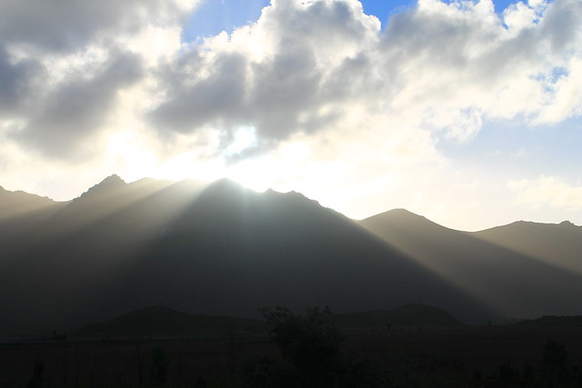
Sunset in western Tasmania taken from the shores of Lake Burbury
I sped down the road, probably faster than I should have been going, trying to make it to Ocean Beach in Strahan before the sun hit the horizon, but I kept coming across beautiful scenery! I next had to take a quick minute at Lake Burbury because the sun's rays were shining from behind the tips of the nearby mountain peaks, casting glorious rays over the land, and I am certain I got some of the best sunset photos I will ever take in my life! And then the drive into Queenstown - famous for its regional mining operations which have all but stripped the hillsides of any and all vegetation and sediment cover. The road coming down out of the mountains to Queenstown was also beautiful, but in an industrial and destructive way. At least Mt. Owen seemed to still be forested and one massive waterfall was cascading down the hillsides.

I got to Strahan with about 15 minutes to spare, drove around the town and out to Ocean Beach where I missed the sun actually setting, though the sky was still beautifully lit up with pinks, oranges, reds, and the blues of the night. I stepped out and down to the beach where I took my shoes and socks off, rolled up my jeans and walked down to the water's edge, finally allowing myself to breathe and take in the dusky views up and down the beach - Tasmania's longest. I picked up a few pebbles as keepsakes as the ocean waters washed over my feet because after all, it's not all that often you can say you've stuck your toes in the Southern Ocean. Tasmania and the southern tips of South Africa, Argentina, Chile, and New Zealand are really the only places you can do this (and Antarctica, too), and it's quite a surreal experience when you consider its vastness.

Happy with everything I was able to accomplish along the Lyell Highway, I drove back to Strahan in the dark, found my hostel - the Strahan Backpackers YHA - and got great advice from the owner for delicious fish 'n' chips, Schwoch's, in the town's centre. A delicious ending to a busy, productive, and beautiful day!

Sunday, August 19, 2012

Sydney: I've moved to a land Down Under

It's about time I update this thing.

A little over three weeks have passed since I moved to Sydney at the end of July. I visited Sydney and some of the surrounding areas last year for a few weeks and had a blast. The weather was warm and sunny, the people were friendly, and I got to do a lot. Australia is one of those weird places in the world, though, that most people from the US just don't understand...at all. We are fed these images of a sunny, tropical, sandy, sometimes dry land with tall, blonde, cheery, extremely fit citizens who go around chasing kangaroos and surf all day. We think of people like Nicole Kidman and Hugh Jackman and think, "What a cool country!" And it is, for the most part. I think Australia is a prime example of a location being completely different when you're visiting than it is when you live there.

Now, to be fair, my preparation for the move to Australia was biased from the beginning when it took Macquarie University four months longer to get me registered as a student and situated with a valid student offer to get my visa than it should have. The upside was that I got to spend four extra and amazing months with wonderful officemates who all became close friends in Glasgow. But the registration process at Macquarie really put a damper on my spirits. But then the paperwork went through and I bought my tickets and things began to brighten up as I started the journey Down Under.

I had to stop at home, in Michigan, first for my brother and new awesome sister-in-law's wedding. The Monday after the wedding my dad drove me to Chicago Midway airport and I felt fine and was excited to finally be making this journey. I was upgraded to first class on my flights from Chicago to Minneapolis and Minneapolis to Los Angeles which is always excellent, but on the flight to Los Angeles, I started feeling achy, my stomach was upset, and I could feel my tonsils swelling up. By the time my flight was due to leave Los Angeles for the 14 hour ride across the Pacific and down to the Southern Hemisphere, tonsillitis was full-blown; I felt awful and it it hurt like hell every time I tried to swallow. I was looking forward so much to that flight because it's kind of an enjoyable time to veg out, read a good book, watch a movie or two, and if you're lucky, you'll have attractive flight attendants. I was flying Virgin Australia, and the entire crew was gorgeous, though of course, I didn't bat an eye as the nice ladies passed my seat. It was Mr. Flight Attendant who kept asking if I wanted a refill on my water that caught my attention. But it wasn't to be, of course, because thanks to my swollen tonsils, I was miserable, couldn't speak normally, and didn't have it in me to take advantage of the free drinks on the flight to give me a little liquid flirting courage (which I feel comfortable enough to say would have been welcomed by him!).

Oh well. I watched a few movies but pretty much just slept the entire time, wanting so bad to just touch down in Sydney. But for some reason, luck was just not on my side during this journey. About an hour out of Sydney the captain announced that we were going to try and land but that the airport was covered by an unusually thick fog. For most airports, fog isn't an issue. But Sydney's airport is not equipped with the proper tools to guide planes to the runway with no visibility. The airport was only landing about one out of six airplanes and the rest were being diverted to Brisbane, an hour north. Our plane descended, but right at the last minute, the pilot pulled the plane up and announced we were Brisbane-bound. My heart sank because all I wanted were some damn antibiotics. I knew as soon as I'd get them, I'd feel better in an instant (at least that what happens each time I get tonsillitis).

The weather was clear in Brisbane and landing wasn't a problem, but then we taxied behind all of the other diverted planes and sat on the tarmac for another hour. It was long enough that the plane ran out of water (but not before I got a small bottle and a number of salt sachets which I used to gargle and try to loosen some of phlegm from my swollen tonsils), had no food, and the pilots even went through the cabins speaking personally to each row of passengers. They explained that what happened in Sydney is so incredibly rare that in their 20-some years of flying into the airport, they'd only been diverted due to fog three or four times!

After an hour and a half of sitting on the tarmac, we taxied up to an empty jet bridge and were directed to disembark the plane with all of our belongings because we would be going through Australian customs here and be re-booked on other flights into Sydney now that the weather had cleared. It was here in Brisbane, on the ground, that I was finally able to get in touch with my advisor from Macquarie, who was supposed to pick me up from Sydney Airport at 7:30am (it was now 9:30am!). He told me to just take a taxi out to the University from the airport when I did arrive. Customs was fairly easy-going, even though there were some inconsistencies with my middle name on my passport and visa, but they let me through anyway with a friendly wave. It was amazing! In the US, I'd've been pulled aside and questioned like a terror-suspect, likely after a full strip search. But I got my bags, and I proceeded to the domestic check-in desk where I was, after again waiting for an hour or so, booked on a small flight into Sydney, which was now taking planes after the fog burned off within an our after our attempted landing (which only meant we could have circled Sydney for an hour instead of flying to Brisbane and been on the ground, at our intended arrival airport, at least four hours earlier!).

My advisor suggested I didn't need to come all the way out to the University which was a 40 minute drive from the airport, but there were still a few hours left in the day and I felt it was important not to waste them and to meet my advisor for the first time in person as well as my co-advisor who I hadn't spoken to or heard from ever before. I got there and everything was fine, except for the fact that I still was suffering from the end of day two of untreated tonsillitis. I was given a cab fare to get to my apartment, in the Camperdown suburb of Sydney, and I arrived in the early evening, meeting my apartment-mate, who was so generous and welcoming, even holding the room over for a few weeks and covering my portion of the security deposit (or bond, here in Australia) just so I could have a place to call home right from the get-go. We chatted a bit, got to know each other some, but then I had to clean up, take a shower, and get some rest.

I unrolled my sleeping bag and inflated my Therma-rest camping pad, because my room wasn't (still isn't) furnished and went to bed. The next morning came very early, and I was up around 3am, but the first thought that went through my head was, "DAMN! It's COLD!!!" Yes, that's right. Sydney is absolutely FREEZING in the winter time - which it is down here in the Southern Hemisphere while the rest of the people I knew were enjoying the warmth of summer. It's not so much the temperature that makes Sydney cold, but none of the houses or building have heaters installed nor do they have insulation. It's like every winter people here think that maybe, just maybe, it will be the last cold winter and that next year the temperature won't drop below freezing at night. They're never right, and because of that, I am so thankful I had enough room in my luggage to pack my sleeping bag which keeps me warm down to 0°F (-18°C), and I am so thankful that my family got me a Therma-Rest before I left for UM's Field Camp way back in 2007! Even though it's only an inch thick, this mattress pad is comfortable and warm, and without it, I am sure my apartment-mate would have found me frozen to the floor the next morning!

The day of my arrival, at the University, I was informed of a mandatory campus-wide introduction for new incoming post-graduate student. It was supposed to be six hour long and from what I gathered would be pretty pointless, though according to those speaking at it, full of information every student must know. Well, this convocation coincided with the only time of the day the Higher Degree Research office was going to be open, and I had to stop there to pick up my healthcare card, which thankfully had been set up before I arrived in Australia. Since I value my personal health over almost everything else, I told the nice office ladies, "Tough shit. I'm skipping that meeting and getting healthy!" (In nicer, more diplomatic words, of course.) With my healthcare card in hand, I oh-too-early sought out the campus's General Practitioner's office at the hospital where the diagnosis was, yup: tonsillitis. And then I successfully predicted the doctor's prescription: penicillin - four capsules a day until the prescription runs out. With two pills down by the end of the day, I woke up the next morning feeling rejuvenated and 100% better! But what a crappy way to start out transition to a new life in Australia.

There's more to tell from these first few weeks, but I have to leave it there at the moment. But I'll give you a little preview: Shock-and-awe at the cost of living, freezing cold nights, field work in the Tablelands, freezing cold nights, finally meeting some people in my department, freezing cold nights, exploring the city's suburbs, freezing cold nights, coping with being so far away from everything familiar, and oh yeah, freezing cold nights.

Friday, October 28, 2011

My Airport Flight Map

Well, I think I've nerded out as much as anyone can. I just spent the last three hours putting this together. It's a comprehensive map of all of the airports I've flown through as well as the routes I've flown to and from (or sometimes just to and sometimes just from). Flight paths are as straight as possible between airports and all flight paths go straight through any intersection with any other flight path without diverging.

Wednesday, September 14, 2011

My Airport List

I absolutely love airports and just reached the milestone of flying through over 50 of them, worldwide. Being in them is one of my favorite things about traveling! There is no better place to people watch and figure out where people are going, why they are going there, and what they are going to do. Most people find airports stressful and dull, but I love little things like the architecture, art installations, and exhibits put up to keep travelers from getting bored. I also find it exceedingly interesting how different airports are organized, what services are available, and how well those services are carried out. While there is a lot to say about airports, I thought I'd just share the list of airports I've flown through.

1. AMS (Amsterdam Airport Schipol) - Amsterdam, Netherlands
2. ATL (Hartsfield-Jackson Atlanta International) - Atlanta, Georgia, USA
3. AZO (Kalamazoo/Battle Creek International) - Kalamazoo, Michigan, USA
4. BOS (Logan International) - Boston, Massachusetts, USA
5. BTV (Burlington International) - Burlington, Vermont, USA
6. BWI (Baltimore/Washington International Thurgood Marshall) - Baltimore, Maryland, USA
7. CDG (Charles de Gaulle) - Paris, France
8. CVG (Cincinnati/Northern Kentucky International) - Cincinnati, Ohio, USA
9. DCA (Ronald Reagan Washington National) - Washington, District of Columbia, USA
10. DEN (Denver International) - Denver, Colorado, USA
11. DFW (Dallas/Ft. Worth) - Dallas, Texas, USA
12. DRW (Darwin International) - Darwin, Northern Territory, Australia
13. DTW (Detroit Metropolitan Wayne County) - Detroit, Michigan, USA
14. DUB (Dublin) - Dublin, Ireland
15. EWR (Newark Liberty International) - Newark, New Jersey, USA
16. GOH (Nuuk) - Nuuk, Greenland
17. GRR (Gerald R. Ford International) - Grand Rapids, Michigan, USA
18. IAD (Washington Dulles International) - Dulles, Virginia, USA
19. IAH (George Bush Intercontinental) - Houston, Texas, USA
20. JAX (Jacksonville International) - Jacksonville, Florida, USA
21. JFK (John F. Kennedy International) - New York City, New York, USA
22. JHS (Sisimiut) - Sisimiut, Greenland
23. LAN (Capitol Region International) - Lansing, Michigan, USA
24. LAS (McCarran International) - Las Vegas, Nevada, USA
25. LAX (Los Angeles International) - Los Angeles, California, USA
26. LGA (LaGuardia) - New York City, New York, USA
27. LHR (London Heathrow) - London, England
28. LUX (Luxembourg-Findel International) - Luxembourg, Luxembourg
29. MAD (Madrid-Barajas) - Madrid, Spain
30. MDW (Chicago Midway International) - Chicago, Illinois, USA
31. MEM (Memphis International) - Memphis, Tennessee, USA
32. MKE (General Mitchell International) - Milwaukee, Wisconsin, USA
33. MKG (Muskegon County) - Muskegon, Michigan, USA
34. MSP (Minneapolis-St. Paul International) - Minneapolis, Minnesota, USA
35. NRT (Tokyo-Narita International) - Narita, Japan
36. ORD (O'Hare International) - Chicago, Illinois, USA
37. PDX (Portland International) - Portland, Oregon, USA
38. PHL (Philadelphia International) - Philadelphia, Pennsylvania, USA
39. RNO (Reno-Tahoe International) - Reno, Nevada, USA
40. SCH (Schenectady County) - Schenectady, New York, USA
41. SEA (Seattle-Tacoma International) - Seattle, Washington, USA
42. SFO (San Francisco International) - San Francisco, California, USA
43. SIN (Changi International) - Singapore, Singapore
44. SJF (Kangerlussuaq) - Kangerlussuaq, Greenland
45. SMF (Sacramento International) - Sacramento, California, USA
46. SNN (Shannon International) - Shannon, Ireland
47. SRQ (Sarasota-Bradenton International) - Sarasota, Florida, USA
48. SYD (Kingsford Smith) - Sydney, New South Wales, Australia
49. TPA (Tampa International) - Tampa, Florida, USA
50. TXL (Berlin-Tegel International) - Berlin, Germany
51. UAK (Narsarsuaq) - Narsarsuaq, Greenland
The tunnel connecting the A and B/C terminals at DTW's McNamara terminal. Transient music plays as the colored panels light up to give you a very surreal airport experience. I will schedule layovers at DTW just so I can spend half an hour riding the moving walkways through the tunnel! One of the reasons why DTW is my favorite airport! (Photo: abc.net.au)

Monday, June 6, 2011

Another Ash Cloud Ruining Flight Plans: Thanks, Iceland

We had three nights left in Greenland, each in a different city: Narsarsuaq, Nuuk, and Kangerlussuaq - in that order. But if you remember, while eating dinner on our last night in Narsarsuaq we saw a C130 airplane land and a bunch of NATO troops got off the plane, which had been rerouted to Narsarsuaq because the Grimsvold Volcano in Iceland erupted sending microscopic particulates into the air above the North Atlantic.

Immediately, we checked our flight plan for the next day. We were supposed to leave Narsarsuaq for Nuuk at 4:30pm, but when we checked the hotel's flight status screen, our flight was not even showing. It's not that it was there but cancelled or delayed; it was just not there... The airport was, of course, closed for the evening and the Air Greenland customer service offices were closed. There was nothing we could do, it seemed, so we took a few minutes to sit down in the hotel lobby and discuss everything that we had seen so far, making sure our scientific expectations, observations, and hypotheses were all in line. Then we went upstairs and lined up all 50-some samples we'd collected thus far in a row, making sure they were all there, and then putting the sample bags into more bags, taped them shut, and stuffed them in two coolers to bring back on the plane with us...if we even were going to get a plane.

The next morning, Paul got up around 6am and went to the airport to see if we could change our reservation to an earlier morning flight. Air Greenland granted us the seats but said that the furthest we could get that day, based on ash-cloud monitoring maps, was Nuuk. In the meantime, the Polar Research Support Staff in Kangerlussuaq was trying to get a hold of us, telling us to get back to Kanger as soon as possible because there were only three C130s and they were all leaving as soon as they possibly could. We hurried and packed the rest of our luggage to check in for our flight.

By the time we got to the check-in counter we had a lucky surprise: we were going to be booked on flights through Nuuk all the way up to Kangerlussuaq, getting us in later that evening. The caveat was that our Nuuk to Kanger flight was dependent on the ash cloud. We would find out upon landing in Nuuk if we could get to Kanger. Earlier that day, all flights in and out of Kanger were cancelled because the ash cloud was heading directly toward it.

With as much concern as there was over the ash cloud, our flight from Narsarsuaq to Nuuk was totally smooth.
View of the Narsarsuaq glacier on our departure flight
Nunataks sticking up through the Ice Sheet with some ice falls and longitudinal crevaces
Buildings and a harbor in Nuuk
Downtown Nuuk
 In Nuuk, we were in the airport for no less than ten minutes when an announcement, made in Danish and Greenlandic, came over the PA system. A nice woman, also an academic, translated for us, telling us that the air over Kangerlussuaq was ash-free, but we would have to fly in from the west after making a detour stop in the coastal town of Sisimiut. And sure enough, in less than two hours, we were landing in Kangerlussuaq....right as one of the three remaining C130s was taking off, which meant there were two left, and we needed to be sure to secure our spot on one of them!
West Greenland coast
Coastal mountains
Large town of Sisimiut
Harbor in Sisimiut
Sisimiut Airport
Sisimiut Airport landing strip
Once we landed in Kangerlussuaq we found out that the next flight back to the US was not leaving until the next morning. We then had the rest of the afternoon to collect a few more samples, but not before a bite to eat.

I was told that I could not leave Kangerlussuaq without trying the Musk Ox Pizza, which is exactly what we did and it was delicious! The guy who ran the pizza place was very friendly and energetic, shouting at the soccer games on the television he had in his shop! Though really greasy, the pizza was some of the best I'd ever had.
Musk Ox pizza with red chiles and onions
One of the few actual restaurants in Kangerlussuaq
We split up our group and collected a few more samples, Paul and I by bike and Jeremy and Dylan by truck. Unfortunately, by the time we met back up, the airport cafeteria was closed and our only food option was back at the Thai food restaurant, which we ate while continuing our trip-summary conversations. We got word that the second of the three flights back home was leaving the next morning and we were on it, so around midnight, we pulled on our eye-shades and went to bed.

The next morning came quick and before we knew it we were back on the canvas and cargo-strap netting seats with about three other scientists and about thirty Air National Guardsmen/Air Force Personnel. These guys had been up in Greenland for a long time already and anxious to get back home and were not fooling around about our takeoff. It was a close call, our flight home, and other Arctic researchers may not have been so lucky.

The last C130 flight back to the US was waiting for the air to clear so they could try and retrieve about 20 scientists stuck up at the Summit Research Station in the middle of the Ice Sheet, directly underneath the ash cloud. They were going to wait one more day to see if they could get the researchers, and if they could not, they were leaving - meaning that the researchers at the Summit Station, who were excited to come home after 3-6 weeks up on the ice, would be stuck for another 3 weeks!

I consider myself lucky not only to have the chance to go to Greenland and experience the wildlife and landscapes it has to offer, but as we were flying away back to the US, I thought how lucky the Summit Researchers were if they did get stuck in Greenland for another three weeks. It's not the most lively place to be stuck, but I can think of hundreds of other places that would be much worse to be stuck.

I plan on returning to Greenland someday, in some fashion. It's not the easiest place to get to, but it's not impossible; it's not the cheapest place to travel, but it's manageable. And I urge anyone who has read all the way down here, at the bottom, to make it a point to get there sooner rather than later. The local culture is still in tact, but with mining companies starting various operations in Greenland, I cannot imagine it will be long before the economic disparity between the European mining executives and local Greenlandic workers becomes so big that the local culture will be dampened.

So to my friends, Sarah and Steve: Yes, people do travel to Greenland and I suggest you get there, too!

Friday, May 27, 2011

Narsarsuaq

The next morning came quickly and we repacked our bags to commercial-airline regulation-weight and caught a ride over to the breakfast cafeteria and airport terminal where we boarded our little Air Greenland Dash-7. We were going south to the settlement of Narsarsuaq, stopping for a layover in Nuuk, the capitol of Greenland. Along the way I was able to snap tons of photos of glaciers, the ice sheet, mountains, and fjords.
Our little Air Greenland plane
Glaciers emptying out into a valley
Nuuk International Airport
Snow covered mountains of southwest Greenland
Nunatak poking through the ice sheet
Beautiful medial moraine and lateral fracture zones
Huge alluvial fan deposit near Narsarsuaq
The town of Narsarsuaq. Population: 100?
Narsarsuaq Airport!
Narsarsuaq is a sleepy little town of about 100 people, yet it has Greenland's second busiest commercial airport. The man sitting next to me on the plane pointed and said, "There's Narsarsuaq," as we approached. I saw the runway and tried to look at what he was pointing to. There were a few buildings next to the runway and I looked at him. He laughed and said, "Yes. That is it!" The town is a tiny, tiny little place on a flat strip of land on the edge of a huge fjord. Upon stepping out of the plane, I couldn't help but look up at the beautiful mountains surrounding me! Other than the ice sheet, this was the Greenland I was expecting to see: huge snow-capped mountains, calm blue fjords, colorful buildings, and a cool breeze. It was mid-afternoon, and after checking into our hotel and making arrangements for the next day's work, we schlepped it up to the middle of another vast outwash plain to collect one more sample.
All of the Greenlandic Ministers (political) were having a conference in the nearby town of Igaliku so the bus took them to the harbor, leaving us with all of our luggage. Luckily, there were no emergencies, so the ambulance drove our luggage over to the hotel for us!
Narsarsuaq Hotel
Little house on the outskirts of town with a small ice-fall up in the mountains
Outwash plain upstream from Narsarsuaq
The clouds danced around the mountains on the walk and while there was not much wildlife in this area, there were other things to see, including some really pretty, but small, bright pink flowers. And on a little mountian right in the town are some of the only actual trees in Greenland. Seedlings from Siberia, the Rockies, Alaska, and the Alps were planted here in the 1970-90s as part of an Arctic Arboretum. And just up the fjord there is an actual forest - though it is also planted for research purposes! And all over this part of Greenland are dozens of Viking establishments and ruins, including the very first Christian church built in North America, Erik the Red's original settlement, and the home of the first Episcopal Bishop. (More on all of those in the next few posts!)

After dinner (musk ox burger!), I took my own little hike up to the top of the little mountain in the arboretum to get some exercise and some good views of the surrounding landscape. It was beautiful and I got my first glimpse of the ice sheet down here in southern Greenland!
Tiny pink flowers growing between cobbles in the outwash plain.
Sun lowering on the horizon
Stone sculpture in Narsarsuaq.
Trees in Greenland!
Looking west from Narsarsuaq
The Greenland Ice Sheet east of Narsarsuaq.
Another HUGE mountain southwest of Narsarsuaq
Looking north from Narsarsuaq - this is like at 10:30pm!
Clouds over Narsarsuaq
Entryway to the Greenland Arboretum

Wednesday, May 18, 2011

Kangerlussuaq / Søndre Strømfjord

I made it to Greenland (Grønland) today, exactly on time at 3:30pm. Seven hours after take off from the Air National Guard Base in Schenectady, New York, we landed at the Kangerlussuaq Airport. We don't have the world's greatest internet connection here, so I'm going to keep it short. 

The plane ride was one of the most comfortable trips I've ever been on. The ANG men are so professional, but so relaxed about flying. After watching an informational video we loaded onto C 130s and took our seats in cargo-strap netted seats. It's pretty much kind of like a hammock, but your butt does get a little sore. That's okay, though, because you can get up and walk around what little space there is. The bathrooms are a little rudimentary. Essentially, you go up to the front of the seating area where there is a little metal receptacle surrounded by a thin curtain. You pull the curtain, open the receptacle, and do what you have to do. But if you really have to go to the bathroom, or if you are a woman and can't use the urinal, there is a sit-down toilet in the back of the plane, between the large cargo crates.
Our field group and our transportation to Greenland
One of the two seating bays
My first view of Greenland!! (If you don't count the gorgeous views I had coming back from Germany earlier this year)
West Greenland coastal mountain range. Look at all that snow and ice!!!
One of the fjords we flew over
And while I'm gawking at the amazing scenery, this is what other people are doing. Greenland? No Biggie.
Most of the people on our flight are scientists of different sorts. There are your geologists (me), the biologists studying caribou migrations, chemists and technicians studying atmospheric concentrations of various gases, stream ecologists studying..well...stream ecology, and others. There are commercial flights up to Greenland, but they are all routed through Copenhagen and this is just easier.

The views on the ride in were stunning. Kangerlussuaq is not far from the western Ice Sheet margin, but it's a good 150 km from the ocean at the end of the Kangerlussuaq Fjord (or Søndre Strømfjord, the Danish for Big Fjord - I think). The town has about 500 people living here and most of them work at the airport (Greenland's largest) or in the food industry serving the tourists who come here to see wildlife and the amazing natural scenery. There is a little Kangerlussuaq Museum here that I hope to visit to get a better idea of the history of the town.

Well, it's now 11:30pm and the sun is just about to "set" so I'm going to don my eyeshades and go to bed. For your viewing pleasure, here are a few more photos of my first real glaciers I have ever seen! (I don't think what's left of the Teton Glacier really counts in Grand Teton National Park because it's too small...)
Beautiful braided streams carrying glacial outwash into this fjord
Can anyone say, "Lateral Moraines?" Holy crap, they're gorgeous!
Kangerlussuaq Airport (SFJ)
Paul, my advisor, getting his passport stamped
And our Kanger home-away-from-home. The KISS building!

Creative Commons License
This work by Eric W. Portenga is licensed under a Creative Commons Attribution-NonCommercial-NoDerivs 3.0 Unported License.