Showing posts with label Australia. Show all posts

Sunday, April 6, 2014

Australia: Whitsunday Islands in a Weekend

Trip Date: 06-08 September 2013


A few months ago, back in early September, I took off early and flew from Sydney to Hamilton Island, one of the entry airports to the Whitsunday Islands on the central Queensland Coast. I’d heard about the Whitsundays from a couple of friends who’d been there before and the more I looked into it, the more these pristine islands, world-famous for their sailing cruises, appealed to me.

Whitsunday Islands
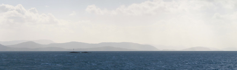
The beautifully hazy Whitsunday Islands

If you’re traveling on a budget and have the time, you might consider flying in to Mackay a few hours to the south. But if you sign up for discount airlines’ emails, you can get affordable tickets right into either Proserpine airport at Airlie Beach (on the mainland) or into Hamilton Island airport on, well, Hamilton Island. When I booked my tickets Hamilton Island was my best entry point and it was still cheaper and more convenient to buy a round-trip ferry ticket to Airlie Beach on the mainland than it is to fly into Mackay and find your way up to Airlie Beach. Alternatively, if you have a good couple of hundred of dollars in your pocket, which I as a student do not, you can just stay out on Hamilton Island in one of their very swanky accommodations.

I got in on a Friday afternoon while the flight was smooth most of the way up, the winds coming in off the Pacific made for a very bumpy and tipsy landing – one of the worst I’ve experienced in a while! With that said, the views coming in to Hamilton Island are stunning. Beautiful blue water, dozens of lush green islands, and stunningly white sandy beaches. It makes landing on a short island runway all worth it!

The weather wasn’t all that great and I began preparing myself for a less-than-relaxing sunny beach weekend than I expected. While waiting for the ferry to take us to the mainland, the clouds came in dark and ominous and at times spitted a bit of rain. Back in February of 2013, a massive storm struck the islands causing widespread damage that was still visible in September as some boats were still washed up onto breakwaters, shoals, and jetties – but of course none of the tourism ads show that but rather want you to think it is always sunny here (something the girls in the row in front of me on the plane clearly had in mind). It all just depends on what you get and you should just prepare yourself to have fun no matter what.

And that was my plan. I’d booked a bed at the YHA in Airlie Beach and planned on doing some beach-visiting, snorkeling, and bushwalking while I was here over the next day and a half. Like all other YHA hostels I’ve stayed at, the one in Airlie was fine for accommodation, though maybe a bit more utilitarian. It was quiet when you wanted it to be and comfortable, though, so I had no problems with it. It is a backpackers’ accommodation though, and one thing you can’t get away from is the constant pressure to socialise with anyone else who happens to be staying in your room. I’d booked a bed in a dorm and there was a nice guy from Sweden in there who immediately started chatting me up. I was fine with that for a few minutes, but the incessant need for him to keep asking me questions about where I was from, why I was in Airlie Beach, and what I was going to do there started driving me crazy. After a series of me giving him one word responses, I decided I needed a sign that reads, “The only reason I’m staying here is because it’s cheap,” especially if I keep staying at hostels rather than the more expensive beach-side resorts.

Cormorant Welcome
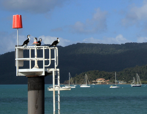
The cormorant welcoming committee in Airlie Beach
I really wasn’t trying to be antisocial, but I had already decided on the flight in that this was going to be a nice me-weekend. Unfortunately, Airlie Beach is just not a place for that as backpackers are literally everywhere and the atmosphere in nearly all of the local pubs and bars plays testament to the party scene Airlie is so well known for.

I decided on a pub for a burger desert – it doesn’t really matter which pub; they’re all crap and went back to the hostel to test out my new LifeProof waterproof iPhone case. Initially, I’d wanted to invest in a GoPro camera for all of the snorkeling I was going to be doing over the next few months, but they’re not cheap and instead I decided an iPhone case was the next best thing. Customer reviews did nothing but rave about LifeProof cases and for $70, I figured I’d take the risk and after unpackaging the case in the hostel and submerging it in a rubbish bin full of water (without the phone in it, of course) for half an hour, the inside proved to be perfectly dry. I was happy with it enough to give it a go out on the reefs.

Early the next morning, me and a few other backpackers (I hate using that term for myself, but it’s just easier) were picked up from the YHA by Ocean Rafting, a company I found through Trip Advisor which is eco-certified and boasts their pro-environmentalism vehemently on their website. Considering the Earth is continuously warming and ocean acidification an ever increasing problem, I figured it would be responsible of me to go out to the islands and reefs with a company that so clearly cares about the environment they take tourists to. Ocean Rafting also was appealing because their boats only take ~25 people on them so you get a much more personalised and intimate tour of the Whitsundays. Finally, Ocean Rafting has a sister company in Cape Tribulation (Ocean Safari) and you can get a small discount if you book a combo trip with both companies and since I’d be going up to Cape Tribulation in October when my family visited, I figured I might as well save a few bucks!

We were some of the first ones out to the dock where our boat, Thunderstruck, was moored and it took a while for everyone else on our tour to show up, but soon we were all squeezed into our wetsuits – a new experience for me – and stepping on to Thunderstruck which was an open-topped speedboat with large pontoons on either side. We could either sit on the benches or on the pontoons and our van-driver that morning said today was a perfect day to ride up front or on the pontoons since the swell coming in off the ocean was still pretty big and the boat was designed for wavy conditions. I had no intention of missing out on any bit of adventure, so I rocked on up to the front row of benches with a truly Irish couple – the guy had a penchant for saying, “Fuck” and “Shit” every other word – which got to be a bit much by the end of the day, but they were good company.

The sun was not out in full brightness yet, but I could tell that the rough weather experienced on my arrival the night before was clearing up and by the time we picked another few people up from Daydream Island and passed through the Molle Islands, the clouds had disappeared and it was obviously going to be a great day! There are dozens of islands in the Whitsundays and when big ocean swells hit them, the waves are refracted around the islands, funneled between narrow passages, and come at you from every which way, which made our boat ride out to the channel between Hook and Whitsunday Islands incredibly bouncy and fun! People were screaming as the prow of the boat lifted up over a wave and came crashing down into the trough on the other side. Our morning driver was right – the choppier the water, the better the ride is on these boats!

We passed through the narrow channel between Hook and Whitsunday Islands and turned right to follow the shoreline of Whitsunday Island which rose up from the sea in steep, bare granite cliffs. It wasn’t before long and the boat slowed down on the opposite side of a skinny peninsula that separated us from the famous Whitehaven Inlet and beach. We hiked up to the ridgeline of this skinny peninsula barefoot and in our wetsuits through the subtropical heat and humidity to a vantage point from which you can see Whitehaven Beach in all of its pristine, white, sandy glory!

Whitsunday Islands National Park
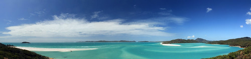
Beautiful turquoise waters and white sand of Whitehaven Beach and Whitsunday Inlet.

To the local Aboriginal people, the Whitsunday Islands are sacred and focus heavily in their Dreamtime stories and of particular significance are the literally thousands of stingrays that call the estuary home. The estuary itself is not terribly long but it is quite wide and the stream flowing out to the ocean is clearly marked from the white sandy deposits by its bold, brilliant, turquoise colour. From the viewing platform, you see not only the stunning estuary, but you look down over bright white sand spits built by longshore currents transporting sand down from Whitehaven beach which stretches as far as you can see in front of you. Geologically, the sand on Whitehaven Beach has been transported hundreds of kilometers along the Australian coast and the purest quartz sand grains are eventually deposited along the beach as coastal currents eddy between the Islands. The fine silica sand is so pure that even on the hottest days it is quite cool to the touch because quartz just does not retain heat well. It is easy to see why the Whitsunday Islands are designated a UNESCO World Heritage Site.

We didn’t linger long at the viewing platform, abandoning it for lunch down on the white sand spit at the mouth of the estuary. The great thing about the tour with Ocean Rafting is that they are the only company allowed to anchor in the estuary itself. No other company is allowed to anchor here and no one is allowed to remove anything from the beach or any of the islands due in part to their listing as a World Heritage site, but also due to their sacred significance to the local Aboriginal people. Only one organization has legally been allowed to remove sand from the beach. Back when NASA was building the Hubble Telescope, they needed the purest silica in the world to melt and form the telescope’s lenses, as any impurity at all would ruin the telescope’s capabilities of photographing space’s wonders.

We spent about an hour on the white sand spit trying to keep our lunches from being stolen by seagulls. No one really talked and while I think it was because of the sun and hunger, I’d like to believe it was because everyone was in awe at this magnificent gem of natural beauty!

After lunch, our boat took us back north toward Hook Island and through what the captain and tour guide referred to as the Devil’s Washing Machine – an area of water where the swirling eddies converge together and the ocean’s wave double in height! Sitting on the side pontoon of the boat, with nothing to hold on to but a small canvas strap between my legs, this proved to be much bouncier of a ride than if I’d had a seat in the boat but it was amazingly fun feeling your body leave your seat as the boat falls back to the water after running off the crest of a wave!

Soon we arrived at the first of our two snorkeling sites on the east side of Hook Island. This was the first time I was going to have willingly jumped into the ocean since I went snorkeling in New Zealand’s Bay of Islands, which was the beginning of conquering my personal and very irrational fear of the ocean! I knew that putting myself in with a group of people who weren’t afraid to just jump in the ocean would pressure me into not being a chicken, but then while the captain was explaining what we’d be seeing at this site, his deckhand pulled a jar of fish food out and started throwing the little kernels of food into the water. As he did this schools of fish too many to count would swarm the water where the food landed – mostly schools of a blue-yellow fish (NOT SURE WHAT IT’S CALLED??).  But what worried me the most was the much larger Maori wrasse – massive fish that can grow to six feet in length with large beak-like mouths. Supposedly, Maori wrasse are harmless, but their size was intimidating enough for me to hold back on the boat much longer than everyone else, petrified to jump in in case one of these massive fish were to sneak up on me!

But money talks, and I reminded myself that I’d bought the waterproof iPhone case for this purpose and that I needed to put it to good use. I slipped on my flippers, tucked my camera into the sleeve of my wetsuit, donned my mask and snorkel and flopped off the side of the boat. I was in, and it was amazing! Whereas we saw heaps of sea urchins and seaweed amongst the rocks snorkeling in New Zealand, there was nothing but fish and coral here! Huge stacks of all of the coral you’ve seen in movies, books, and pictures and just as many types I’d never seen or heard of before! There were loads of fish – mostly the ones schooling around the food but also rainbow parrotfish, big fish, small fish, and yes, even the great Maori wrasse which I saw sneaking up on me from behind, though turned away before getting too close to me!

We were in the water for about an hour before being called back to the boat, which didn’t take me long as I didn’t dare venture too far away, but took some of the more intrepid explorers a wee bit longer. Because of the windy weather that hit the islands on the previous few days, sand had been stirred up all around the islands that made visibility low and the captain thought we might have better luck a few bays further around the island. We made the short trip to the next bay and spent another hour or so exploring the corals here. Indeed visibility was better and I was a bit more adventurous and tried seeing as much of the reef as I could. It was truly like being in an underwater wonder world and even I was amazed at how quickly my inhibitions melted away under the spell of the reef.

Hook Island Reef
Parrotfish on the reef!
I think everyone should be able to experience a tropical reef up close at some point in their life  - though the scientist in me cautions anyone who does to be very conscious about what company they use to get to the reefs. Climate change, warming ocean waters, and acidifying oceans are killing reefs all around the world. They are some of the most delicate and fragile ecosystems in the world yet are crucial for the survival and sustenance of all the oceans.

It was getting late and we boarded the boat one last time before finishing our circumnavigation of Hook Island, past the old resort of Hayman Island, and back toward Airlie Beach. The seas were still rough but I wasn’t upset I once more found myself riding the pontoon on the way back for one of the wettest rides on the boat!

There’s nothing to report from my second night in Airlie Beach because it’s a dive and not worth wasting words on.

I woke up early on my third day in the Whitsundays and walked back to the ferry docks to catch the first ferry back to Hamilton Island. My flight back to Sydney wasn’t until later in the afternoon, but I wanted to do a bit of bushwalking and it looked like there were some great trails on Hamilton Island. Indeed, once you get past all of the resort villas, bungalows, hotels, condos, and conference centres, you find a track that leads up to the rocky lookout called, Passage Peak.

It only took about an hour to reach the peak, though unless you’re an avid hiker, I’d plan on it taking more than that. The weather was hot, but the sky was perfectly clear for looking out over the islands from one of the highest points in the islands! Fluffy white clouds marched through the sky in endless precession, casting shadows on the clear turquoise water. I had a nice chat with some other bushwalkers at the top and they pointed out some pairs of whales they’d seen while I told them about Whitehaven Beach which you could see over the lush green slopes of neighboring Whitsunday Island. Though it was Sunday in Australia, it was a Michigan Game-Day Saturday back home, and in true fashion, I proudly wore my UM Jersey, which I also had to explain to the other hikers, but they generously took photos of me, saving me from yet more selfies. Eventually they left and thus left me to one of the most spectacular viewing points of natural beauty I’ve ever seen!

Wherever You Go, Go Blue!
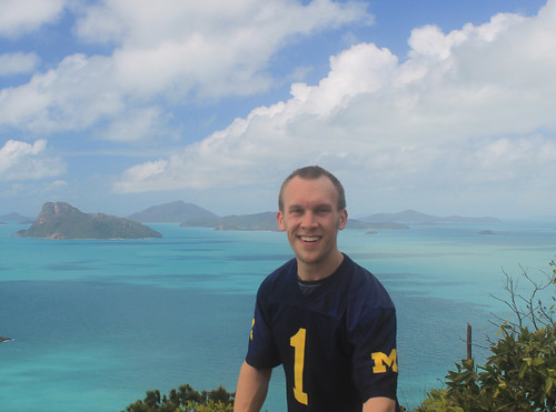
Going Blue during a bushwalk to the summit of Passage Peak on
Hamilton Island. I believe we beat Indiana that day!
I had plenty of time to walk back to the airport, so I took my time with it singing Michigan Songs from Glee Club on the way down since I think it was the weekend we beat Indiana. I called and chatted to my sister over lunch and then made my way to the airport which is conveniently within walking distance from the marina and after not too long was back in the air headed home to Sydney. 

My weekend in the Whitsunday Islands reaffirmed what I’ve learned so often in Australia: it does not take much time or money to have amazing experiences in beautiful locations. I was away for less than three days, yet I have some of the most vivid memories of nature, landscapes, the ocean, and animals I’ve ever had. If you get the chance, go! To the Whitsundays, absolutely, but also to anywhere you’ve been wanting to see!
 

Australia: Skiing Perisher and Thredbo

Dates Traveled: 9-11 August 2013

It was a Thursday before a weekend I was not planning on leaving Sydney, but I had some friends driving down that night for a long ski weekend in Australia's Snowy Mountains. An invitation was given kind of last minute as someone had dropped out and there was suddenly space in the car. While my bank account said, "No," my heart said, "Go!" And soon, I was off for my first International skiing experience!

Australians don't seem to realise just how cool their own backyard is, it seems! Everyone I spoke to about skiing in Australia just kind of scoffed at their resorts and in a seemingly ashamed way told me that, "Well, it's nothing like New Zealand, or Japan, or the Rockies, or the Alps." But growing up in Michigan, skiing anywhere that is more than a big hill is pretty exciting for me! But it wasn't just the quality of skiing Australians scoffed at. When I told people I wanted to climb Mt. Kosciuszko, Australia's tallest peak, which is in the Snowy Mountains (in Kosciuszko National Park), the typical response was, "Oh, don't waste your time. You don't really climb it but walk up to the top, anyway." So because of all of this, I wasn't really sure what to expect. The main resorts in New South Wales are near the town of Jindabyne, pinched between the New South Wales-Victoria border and the Australian Capital Territory. I'd been to Jindabyne the previous November while doing field work and saw all of the rental facilities, restaurants, repair shops, and hotels that were all closed for the season then, and I figured that surely the skiing must be good enough to support this much infrastructure.

The Snowy Mountians
The aptly named Snowy Mountains, Australia's highest mountain range
Needless to say, I was confused about the trip, but was excited to go. There were five guys that I knew going, both skiers and snowboarders of various levels of expertise and after a night spent in Cooma, we stopped in Jindabyne to pick up a few sets of rentals for my friends, and continued on the road up to Perisher where we were going to spend two days skiing.

Let me say this, and let me be clear about something: Australian mountains are nothing to be ashamed of! The granite mountains were tall with wonderfully deep valleys and the white snow that blanketed the tops of the mountains contrasted awesomely with the green valleys! Of course they aren't Alps or Rockies, and the ski resorts are few, but that area is beautiful!

I quickly hurried in to get my rentals from the resort and by mid-morning, we were all set to go! The sun was shining and we all set off as a group around Perisher. I've never skied anything like Perisher before! The granite mountain was nicely rounded and there were huge outcrops sticking up out of the snow which made the resort to be a veritable playground for a quality skier. Plenty of little jumps to hit and nice tree-less runs that you could build up huge speeds with enough space to race in and out of the outcrops.

Cloud Cover
White-out conditions on top of Perisher
It didn't take long for our rather large group to splinter and my friend Craig and I were soon off to explore more challenging terrain. The west end of the resort is where the highest slopes are and we slowly worked our way up to the lifts on the far side. As the afternoon carried on, the weather started to get nasty and an incredibly dense fog moved in, but only blanketing the top of the mountains. We kept taking the lifts up, though it was pretty scary skiing down a slope on ice where you can only see a few metres in front of you! Once we got about a third of the way down, though, it was still foggy but you could see much farther, and then at the bottom everything cleared up just fine. We did that a few more times but the fog got worse and soon I couldn't see where Craig was. I noticed some orange posts in front of me to my left and to my right with a gap between. Knowing that the posts indicated huge rocks I should try to avoid, I decided to go through the middle. Looking over my shoulder for Craig to show him which way I went was a mistake because as soon as I did, my skis dropped out from under me as I went off some sort of steep edge and my body slammed into a snow bank below. I thank God there wasn't a rock there and that I had my helmet on, because I hit the ground hard! Somehow or other, Craig saw me and came to my aid laughing at me all the while.

Perisher
Perfect weather in a beautiful winter wonderland at Perisher
I was a little dazed, but got up quickly enough and we kept going until the lifts shut down for the night. The great thing about the bad weather that night was that it gave us a ton of awesome fresh powder for the next day, which weather-wise, was the best you could have. Clear and sunny, warm but skiable. Our group started off together, but again split up shortly into the day, meeting up every so often to do a few runs or get a coffee. One of the really weird (but cool) things about skiing in Australia is that you're skiing through gum trees which don't lose their leaves ever throughout the year. So while anywhere else in the world you ski through evergreens and leaf-less gray trees, in Australia, you ski through lush green vegetation. And the branches are high enough that there is plenty of room to maneuver through them like wide open glades. Like I said, Perisher was just a skiers playground! Plenty of great runs, fun terrain, and lots of variety!

The third day we switched it up a bit and headed to the nearby, and probably more popular resort of Thredbo. Thredbo occupies generally steeper terrain and the runs are your more typical alpine runs and lanes as opposed to Perisher's openness. Australia's highest lifted point is here, and it is well above the treeline so the winds just rip across the mountain top, blowing away much of the powder and leaving behind a thin sheen of ice that you really have to carve through to get your hold. It wasn't long before three of us headed up to the top (via a series of T-bar lifts, which I found really bizarre!).  Here too, there were big granite outcrops and Rick, Craig and I started off toward the Golf Course Bowl (not sure why it's called that - I get the bowl part, but not the rest), but it was roped off so we had to navigate our way down a different way. There was a turnoff to go down an insanely steep chute called Cannonball and Rick and Craig just took off. Not wanting to get too far behind, but being less adventurous than them, I took my time. And holy hell!! It was pretty much a vertical drop covered with moguls with nothing but ice to try and grip into! Needless to say, it put my skills to the test, but I got through.

THE TOP
The highest lifted point in Australia! Top of the world!
A fun thing we all did throughout the weekend was track our runs using the Alpine Replay app for our phones. The app has trail maps from ski resorts around the world loaded in and uses your GPS position while you're on a chairlift to figure out exactly where you are. It then monitors your speed, records the total elevation you've skied, and tracks the runs you've taken with GPS. It also uses the accelerometer inside the phone to log how many jumps you've landed and how much air time you've had throughout the day. Without meaning to, I checked my speed at the bottom of one of the runs I bombed down and saw that I reached a top speed of 79.4 kph (50 mph)!! For the rest of the day, I tried breaking the 80 kph barrier before I realised it was a reckless endeavor and that I'd end up seriously injuring myself if I didn't stop!

The Guys
The guys who ski!
Anyway, it was a great time with good friends and we had the most perfect weather for the weekend! By late afternoon of that third day, it was time to pack up and start the long six-hour drive back to Sydney. I may have learned to ski on little wee hills in Michigan, but I've skied the Green Mountains and the Appalachian Mountains in Maine, and I've got to hand it to Australia. Your resorts may be few, but they are fun and challenging and it was well worth taking some time out from my week to spend it in the Snowy Mountains with great friends!

Australia: Kings Canyon / Watarrka National Park

Travel Date: 20 August 2013

We didn’t have to wake up as early this morning as we did the previous morning, but after an early rise, and a quick pack up of our swags and gear back into the bus, we made the short drive to Kings Canyon in Watarrkah National Park. Kings Canyon lays claim to being the world’s largest canyon, surpassing all others including Arizona’s Grand Canyon, because “technically the Grand Canyon is a chasm.” I had even read that Kings Canyon was even more impressive than Uluru, so needless to say, my expectations were very high!

From the parking lot, Adam pointed out the canyon which cuts its way through the sandstone ridge to the north, and to the trail that we were taking which follows the rim of the canyon. Looking at it from the parking lot, it was clear that my expectations of grandeur were going to be dashed. Semantics aside, the canyon is definitely not bigger than the Grand Canyon (not by a long shot!) and in my opinion, not more spectacular than Uluru.

Kings Canyon Illumination
Panorama of Kings Canyon in Watarrka National Park

 With that said, Kings Canyon is marvelous! The trail heads up Heart Attack Hill to the top of the rim and winds in and out and between impressive sandstone formations that have weathered over time into these dome-like features. Erosion along joints – natural fractures in the rock – wore down the rock in grid-like patterns and some of these more deeply-eroded joints are what separate one dome from the next. And in the extreme case of Kings Canyon, stream erosion cut down hundreds of metres into the sandstone carving out a spectacularly beautiful canyon filled with eucalypts and other green trees. You might even recognise the landscape of Kings Canyon if you’ve ever seen the seminal Australian film, The Adventures of Priscilla Queen of the Desert as this is where the shot of the three drag queens stand on the Canyon’s edge in their fabulous dresses and feathery headwear!

Kings Canyon Vista
Dome structures created by erosion along joints in the sandstone dot the
landscape of Kings Canyon in Watarrka National Park
The trail eventually takes you to the narrowest part of Kings Canyon where you descend a few flights of stairs to The Garden of Eden, an aptly named oasis where water collects in large permanent water holes spanning the narrow canyon width with towering rock cliffs rising above your head. Palms and more tropical gum trees fill the lush Garden in stark contrast to the scrubby and white ghost gums growing up on top of the canyon. The ponds were a great place for a small lunch and break from the sun, but soon enough we headed up another flight of stairs and continued to an amazing canyon lookout where we could belly up to the edge of the canyon and look straight down the cliff faces!

The trail finishes by coming down the mouth of the canyon opposite Heart Attack Hill and those of us at the front of the group lamented as we waited for the stragglers who were taking photos of every single flower, rock, small lizard, spider, or whatever they could find. Adam was about at his wit’s end trying to keep us on schedule, but we eventually mustered back at the bus and we began the 6-hour drive back to Alice Springs.

Ghost Gum Trunk
Looking up the trunk of a ghost gum in Watarrka National Park
We had yet to use the bus’s 4WD capabilities, but instead of taking the paved road back to the Stuart Highway via the Lasseter Highway, we bounded off the pavement making a bee-line straight back to the Stuart via a series of dusty, dirty, bouncy, bumpy dirt roads that no normal vehicle would survive! It was great fun and the vibrating floor provided for a nice foot massage after three days of intense walking! Everyone seemed to be enjoying it except, of course, for the Canadian fashionista who clearly had no concept of what four-wheel-driving was all about. At one point, the bus came to a stop as Adam had to get a clear look as to how best to navigate through an area of soft sand. The fashionista opened her eyes as we stopped, looked out the window and in a moment that defies all logic turned to me and asked, “Is this Alice Springs?” There were no buildings to be seen anywhere around us and we’d only been on the road for a few hours, and in disbelief at her question just stared at her and shook my head. “We’ve still got at least three hours,” I said. She just scoffed and started getting all worked up again at how annoying it was that we weren’t there yet, and what was this bumpy road? She couldn’t even get a good nap! While she was a very nice person, surely with good intentions, I could not wait to get away from her negative attitude. It just astounded me that someone could be so unprepared and not have even the slightest idea of what she was signing up for when she booked her trip. She was a trooper and did everything the rest of us did with a smile, and a joke, and funny stories, but I was glad that in a few hours time, I was not going to have to listen to her complaints ever again!

The rest of the drive back to Alice Springs was pretty uneventful. We didn’t make any more stops, and we didn’t see any more wildlife, but that was alright. Once we were back on the paved road everyone started to nod off. Being on a trip for a few days, with the same people day-in and day-out can be tiring when you know who you’re with, but when personalities don’t match, 3 days can sometimes feel much longer!

Back in Alice Springs, everyone was dropped off at their hotels and hostels and I’m sure no one wanted anything more but to take a much-needed shower and just a bit of quiet alone time for a short while! I know I enjoyed mine! That night, though, we all reconvened at a pub for tour-discounted dinner and beers. It was sort of the last-hurrah as we all talked about our amazing three days in the Outback and talked about what our next planned adventures would be.

It was overall, a great three days of good company, amazing scenery, rich culture, and fun. It made me realise that organised tours and playing backpacker can be really fun, and sure, you might not see those people again, you all shared an experience, and that is really what traveling is all about, and this was no exception. An amazing three days were now over and I had one more night in Alice Springs before my flight left the next morning.

The morning of my flight, I had a few ours left to explore bits of Alice Springs and I walked to the café at the Olive Pink Botanic Garden across the River Todd. It is a much longer walk than it looks on the map, but the café was really good, and the botanic gardens were nice for a quiet morning before flying back to Sydney, re-entering the busy city life. A quick walk up the hill in the Botanic Gardens gave me one final glimpse of the dry, but brilliant landscape that is the Northern Territories and I’m already looking forward to the day that I return there.

Australia: Kata Tjuta

Travel Date: 19 August 2013

Just like watching the swirling colours of the sunset on Uluru the night before, watching the sunrise behind Uluru, illuminating its neighbouring rock formation, Kata Tjuta (better known as The Olgas) is not to be missed! Our tour was woken up nice and early in the pitch black and chilly cold. We quickly collected our belongings and rolled up our swags, and clambered into the tour bus for a 40-minute drive west to a viewing platform bang in the middle of the two amazing rock formations.

Uluru Sunrise
The sunrise in the east behind Uluru
The Olgas are in some ways more impressive than Uluru, albeit being much less known (though they feature prominently in the opening sequence to the Disney film The Rescuers Down Under). Whereas Uluru is one massive rock, Kata Tjuta is a cluster of towering rock stacks with rounded tops, and they are even taller than Uluru! Geologically, the rocks at Kata Tjuta and Uluru date back over 500 million years! An ancient mountain range to the west that was created during the Petermann Orogengy was the source for all of the sand and boulders that were eroded from the mountains and deposited in a large basin to the east of the mountains. Over time, these sediments built up and compressed earlier depositional strata into the sandstone and conglomerates that make up these rock formations. Over time, further compression and faulting tilted the rocks such that previously horizontal strata are now almost vertical! While Uluru is mostly sandstone, large boulders stick out of the steep conglomerate rock walls of Kata Tjuta.

We stopped at a designated viewing platform for the sunrise and along with at least one hundred other people waited as the sky started to lighten up behind Uluru to the east and eventually the sun peaked up over the horizon, silhouetting Uluru in the distance while illuminating the massive domes of The Olgas, turning them from shades of gray to pink to orange and yellow and red. It was a beautiful setting to be sure; however, the sheer number of people and cameras continuously clicking and the Canadian fashionista’s complaining about the cold made it much less peaceful as it could be, though if you could block those sounds out in your head, you could just imagine what it would have been like to see this every morning without the nearby roads or viewing platforms, and the whole experience takes you to a whole new place.

Breaking Light on Kata Tjuta
The breaking sunlight on Kata Tjuta (The Olgas)
Again, we had a lot of ground to cover today, and Adam, our guide, wasted no time in getting us back onto the bus and brought us to the parking lot at the locality of Petermann. The sun was already high in the sky. Considering the throng of people at the sunrise viewing platform, there were amazingly few people here at Kata Tjuta. As much as I loved how quiet it was here, it’s really too bad that so many thousands of people come all the way out here, to the middle of this huge country to get on a bus, drive to a viewing platform, take a few photos, and hop back on their plane. I can’t lie, I also took a lot of photos, but that is never enough for me. I couldn’t come all the way out here and not have an experience, to walk through the landscape, or listen to the wind and birds, or feel the sun’s radiating heat. I wish more people desired experiences in nature. Maybe we’d all have a better appreciation for our planet and our environments and become better, more humble people.

We got off the bus and prepared for a hike through the Valley of the Winds which takes you from the parking area between some of the massive rocks that are The Olgas and into the valley protected between them. Even in August, Australia’s winter, the sun can become too intense to be outside this far in the Outback, so any hikes should start promptly in the morning. The Olgas are also incredibly sacred to the local Aboriginal communities, but curiously, outside of those communities, no one knows why. At Uluru, there are places where you cannot take photos because of spiritual significance, but there are signs explaining why the site is sacred. At Kata Tjuta, nothing is off-limits, but the whole area holds such a deep spiritual importance that only those in the Aboriginal communities can know what it is!

Kata Tjuta - Valley of the Winds
Down in the Valley of the Winds at Kata Tjuta
The Valley of the Winds is aptly named as air from the heating rocks rises and pulls in air from the surrounding area that gets funneled and focused in the valleys between the rocks. It’s not a difficult walk into the valley, but it is a stunning walk as you work your way between amazingly steep rock walls with massive boulders sticking out. The valley itself is made up of gently rolling rocky hills with scrubby vegetation and a few gum trees dotting it. The walk takes about three hours, provides spectacular scenery dotted with intricate flowers, and is incredibly peaceful as anyone you walk past just smiles and nods their hellos, not wanting to ruin the quiet atmosphere. Because no one knows the real significance of Kata Tjuta, there almost isn’t much else to say because there is nothing to interpret.

We finished our walk in the late morning and set up our lunch back at the bus before we packed up at set off for another long drive. We left Kata Tjuta, passed Uluru once more, and drove the hour or so back to the Curtin Springs Roadhouse for a quick break before turning off the Lasseter Highway onto Luritja Road toward Watarrka National Park, home of Kings Canyon. We stopped once more to collect firewood for that night’s dinner that was a fun, if not frustrating pit stop. The Canadian fashionista hadn’t been with us the previous day when we collected firewood and was trying to write postcards to send back home as our bus drove down the bumpy, dusty dirt road. Trying to write while driving over washboard road conditions is no easy task, and one more than one occasion, she would slam down her pen and shout something along the lines of, “I’m trying to write a postcard! Can’t the bus just stop so I can finish? This is so hard!” Complaints that received nothing but an annoyed look from me as I asked her what she expected! My postcards were barely legible because of all of the bumping around, but I thought it was part of the fun! Not only was I describing to my family what I was doing, but they could actually see it in the squiggles in my lettering! She didn’t seem to understand and got even more flustered as the bus swerved to the left and right. Once we stopped, she finally finished her postcards (though she took her time, probably not wanting to get her clothes too dirty with all the red dust) while the rest of us ventured back out into snake country to collect firewood.

Camel Herd
A herd of feral camels in Australia
And we were in store for a treat before we left. As we loaded back onto the bus, someone spotted a little brownish-gold body bouncing between the trees and a single solitary dingo sauntered up to the bus! Frankly, I expected to see more dingoes than we did, but the curious little creature was the only one we saw and after figuring out we had nothing to offer it, he quickly sauntered away just as quickly as he came.

Further down the road, we were in for another treat as a massive herd of wild camels was socialising on the side of the road. Adam stopped our bus and we all got out, quietly stepping as close as we could to these amazing creatures without spooking them! There were dozens of them – mostly adults, but a few young ones, too and they just moved together, minding their own business. We stayed there, watching them for a while as another brilliant sunset lowered down toward the horizon. It was just such an odd sight, seeing the camels, not only because they are just funny looking animals, but because you just know they aren’t supposed to be there! The wild camel herds have naturalised so easily to the Australian Outback, their numbers can’t be culled. They’ve repopulated so well, and from such a small original stock, that people in the Middle East actually buy their camels back from Australia because the Australian camel genetics are so pure, they fetch quite a high price back in the Middle East!

The setting sun was blinding as we drove west  to Kings Canyon Resort but we eventually pulled in to our campsite for the night, got our fire up and blazing, made dinner, and set up our swags for another chilly night under brilliantly clear skies in the middle of the Outback.

Australia: Uluru


Travel Date: 18 August 2013

It was a rough morning trying to wake up on time and be out in front of the YHA Alice Springs in time to be picked up for my 3-day adventure in the Outback. Though I originally wanted to rent a 4WD and do the trek from Alice Springs to Uluru with friends, I wasn’t able to convince any of my friends to come along on this trip with me and I sure as hell wasn’t about to tempt fate by doing it on my own because with some of my travel luck, I’d inevitably get bogged down in some sand, run out of water, and get bitten by a snake trying to find a cell signal! So I booked a 3-day tour of some of the Outback’s most famous sites.

WayOutback tours offer a number of trips ranging from 3 days to over a week, some of which are more rugged than others. The one I’d booked was “all inclusive” in the sense that all food was provided for, sleeping arrangements were already made, and all I had to do was show up, sit down in the bus, and enjoy the scenery. Soon enough, a big…truck? I’m not entirely sure how to describe it. It was a vehicle that had the front cab of a small semi-truck and instead of a cargo hold on the back, it had a relatively small coach like a charter bus with big windows and two seats on either side. The bus accommodated 24 people and was jacked up on big 4WD tires.

Our driver, Adam, helped the two of us being picked up put our luggage in the storage hold on the back of the bus. It took us a while to pick up everyone else from their respective hotels and hostels around Alice Springs, but soon enough we had a nearly full bus with people from all over the world: an American girl, her father, and her Swedish friend, a hip-hop dance teacher from Amsterdam, a girl from Glasgow, an adventurous guy from Vancouver, and your typical handful of German and French backpackers.

The bus was chatty at first as we all were introducing ourselves and going through the typical banter common amongst backpackers in Australia, but it was still pitch black out and we had a good 6-hour drive ahead of us and soon enough everyone was sleeping.

The thing anyone needs to know about the Northern Territories is that there are very very few towns and everything is incredibly far apart! When you drive down the highway and come across a petrol station or bathroom, you stop and fill up and use the bathroom because you never know where the next one will be. Between the towns are small roadhouses that usually have a gas station, some hotel rooms, camping spots, toilets, and a bar.

Sleepy Dingo
Sleeping dingo at the Stuart's Well Roadhouse south of Alice Springs
Our first stop was at one of these roadhouses, the Stuart’s Well Roadhouse, and it was the first chance we had to stretch our legs, and grab a coffee. This roadhouse was unique in that it also had a number of pens where Australian animals like emu, kangaroos, and various birds were on display for tourists stopping in. But they also had two of the more unique sights in the Outback: camels and a dingo. Camels are obviously not native to Australia, but were imported from the Middle East because of their hardy survivalist instincts in desert environments and the preferred cargo animal over horses, which require a lot of water. A transcontinental telegraph cable was built from Adelaide to Darwin with Alice Springs being used as a transfer point along the way. Camels were used by the crew that laid down the cable. But like many non-native animals in Australia, some of the camels escaped and proliferated in the desert and today there are over one million wild camels roaming Western Australia and the Northern Territories. Dingoes were also introduced to Australia over 40,000 years ago and have also adapted and proliferated throughout the continent and have just recently been described as a separate canine species and not just a variety of wild dog. The one dingo at this roadhouse was old and used to tourists, so was not caged up and was pretty snoozy and docile.

Adam, our driver, didn’t let us linger too long as we still had a long ways to go. We drove another few hours to the Erldunda Roadhouse for another bathroom break, and turned off the Stuart Highway onto the Lasseter Highway toward Uluru.

Most people have visions of Australia’s Outback as being rocky with lots of sandy deserts, dry eucalypts, and brilliant soils stained red by the rusting of iron in the dust and soil. These images are spot on what you actually see and it is beautiful! Nothing but flat land as far as the eye can see until a few low-lying rocky ridges or mesas rise up in the distance, like Mt. Conner. But I was surprised at just how green it was! The trees were, by no means, lush and foresty, but the gum trees here were not as brown and dry as I thought they would be – really a testament to just how well-suited for every microclimate in Australia these trees are!

Mt. Conner
Mt. Conner off in the distance near Curtin Springs
We pulled off the main road shortly before the Curtin Springs roadhouse to collect some firewood for our campfire that night. Part of the reason why I booked this particular tour is that while everything was catered for us, we still had to participate in collecting firewood, preparing dinner, and washing up dishes. It gives you that little tinge of roughing it! Like anything in Australia, simple tasks, like collecting firewood carry inherent dangers. Out here, it was snakes. Some of the world’s most deadly snakes are found throughout Australia, but exceptionally potent ones here in the Outback. We had to be very careful when picking up dead wood that no snake was sunning itself nearby! But soon enough we had our firewood, and we made our pit stop at Curtin Springs, and carried on west to Uluru.

There were a lot of rocky plateaus and mesas in the distance along the Lasseter Highway and every time we thought we saw Uluru, Adam would shake his head and assured us and assured us, “You’ll know when you see it!” And sure enough, another few hours down the road, the rock loomed into view, dwarfing any and all other mesas we’d seen! Everyone knows what Uluru looks like as it’s one of the most photographed rocks in the world. And with good reason! It’s the world’s largest monolith – or single rock, and it juts up from the flat Outback surroundings to over 300 m in height. We kept driving closer and closer and Uluru kept getting bigger and bigger. Finally, we pulled into our campsite in Uluru-Kata Tjuta National Park.

I couldn’t wait to get up close with the massive rock, but it was going to have to wait a bit. A few more people were joining our tour, but were flying directly in to the airport at Uluru, rather than Alice Springs, so Adam gave us directions for lunch and he left to pick up the others. Soon he came back with a French family that had a few kids with them, and a blonde girl from Canada who was finishing up teaching fashion at a school in the Melbourne area. I’m not entirely sure if she knew what she was signing up for. Everyone else was dressed in hiking and outdoor gear and those of us who’d collected firewood were already covered in dust, whereas the Canadian fashionista rocked up in a flowy sequined top, hair done up like a pro, and flip flops more appropriate for a cocktails near the beach than heavy walking in the Outback!

With lunch in our stomachs, Adam gave us the cultural sensitivity talk about Uluru. The rock features in numerous Aboriginal stories about Tjurkupa – the creation time of the world – and is a very sacred site as it is the birthplace of the Anangu people who still reside at Uluru. As European Australians had a penchant to do, they named the rock after the Chief Secretary of South Australia (Ayer’s Rock) and it became known as Ayers Rock – Mount Olga National Park, under the government of the Northern Territories until 1985 when the park was given back to the traditional owners of the land and renamed Uluru – Kata Tjuta National Park. One of the most popular things to do at the park is to climb to Uluru’s summit and there is only one trail to the top, but because of Uluru’s sacred importance to the Aboriginal communities, doing the climb is not recommended by any of the tour companies who have access to the park, though they all allow the tourists the option.

Uluru Sunset
Finally here! Uluru!
As a geologist and someone who loves a good hike, I was really tempted to do the climb, but when our bus pulled into the parking lot and we saw a full charter bus-full of tourists swarming up the trail to the summit and I just felt sick from the blatant disrespect for this sacred site. A small group from our bus decided to do the hike, and I understand their decision, but I thought that in the long-run, I’d feel better knowing that I hadn’t tread on sacred ground without fully understanding its importance to the local people. Thousands of people do the climb each year and some of them even feel the need to pick up a little stone and take it home as a souvenir from Uluru. In the National Park’s Visitor Centre, though, there is a binder full of letters from people who, after taking the stones from Uluru, experienced so much bad luck and racked with guilt that they mailed the stone back to the park in an effort to rid themselves of their curses. These small rocks are now collectively known as Sorry Rocks.

While the hikers did the climb, the rest of us did the short Mala Walk to Kantju Gorge. Uluru has a lot of curves creating alcoves along its base which are perfect for allowing water to pond and gives the appearance of little oases in the Outback. The Mala Walk took us past a number of sites that are featured in the creation stories of the local Anangu people. Some of the rock caves at Uluru’s base contain carvings and petroglyphs that are thousands of years old. The trail leads you to Kantju Gorge which features a small water hole at the base of a cascade of steps that have eroded into the steep sides of the rock over millennia.

By the time we got back to the parking lot, the hikers hadn’t yet returned, so the rest of us drove around to the Mutitjulu Waterhole around the other side of the rock where there is an even bigger waterhole and forms in the rocks tell the story of  Kuniya, a python woman who had traveled from the east. Kuniya’s nephew had been killed by the Liru, poisonous snakes. When Kuniya arrived, she exacted revenge for her nephew by taking her walking stick and striking the Liru with it, killing him.

The day was getting on and sunset wasn’t far away. Next to the Uluru climb, one of the most popular events every day is to watch the sunset on Uluru. The bright orange sandstone takes on a new life as it’s shadows and colours change in the dimming light. Our bus pulled into a parking lot that was just swarming with tour buses and vans, each with their own cohorts of tourists sitting around make-shift tables while everyone sipped on champagne and snacked on finger-foods while watching one of the most beautiful sunsets in the world. The bright orange rocks faded in and out of various hues of red and pink as the sky behind it darkened. The shadow of the western horizon slowly works its way up the rock until the final moment when the only the tip of the rock is illuminated a gentle pink colour before the shadow envelops the entire rock. Even with all the people around, I was able to take a little walk down a path where there were far fewer people and the whole sunset just becomes a peaceful experience leaving little doubt that this gigantic rock is indeed an intensely spiritual place.

With the sunset over, we bussed back to our campsite where some of our group got a campfire started so we could cook dinner while the rest of us started to prepare our beds. There were large stationary tents at the site, but the weather was wonderfully mild and we all had the option of sleeping in swags under the stars. Swags are nothing more than a big canvas bag that has a rough sleeping pad inside and you then put your sleeping bag in the swag on the pad. A canvas flap can then be pulled over your head in case it were to rain. Swags feature heavily in Australian culture, most notably in the song “Waltzing Matilda” in which Matilda is actually the name of the man’s swag! I don’t think I ever met a respectable Australian who didn’t have a swag or hadn’t spent a night in one. Being in the middle of the Outback, at Uluru, there was, for me, little choice about spending a few nights sleeping under the countless stars in my swag.

With our stomachs full of food and beer, it wasn’t long before everyone was comfortably in their swags (or uncomfortably in the case of our Canadian fashionista!) and fast asleep. It wouldn’t be too long, after all, before we would wake up at 4 am for our next day’s worth of amazing Outback experiences!

Sunday, September 29, 2013

Australia: Alice Springs

Travel Date: 17 August 2013

Note: I am well beyond an outsider in Australia and there is a lot to learn about the Aboriginal cultures and ways of life. It is and can be a very sensitive topic in many Australian communities and if my wording or interpretation of what I learned is incorrect or offensive, please let me know. I am trying to be as truthful and as historically and culturally accurate as possible. Thanks!

Over the last few months, I've been watching the airline sales in Australia like a hawk. I was about halfway through my time in Australia for my PhD and was feeling a bit of a mid-Aussie-crisis and realised I might not get to see everything I wanted to if I didn't hurry. I'd planned to visit Australia's Red Centre in the southern Northern Territories in January when I have a bit more time, but then it dawned on me that the weather in the outback in January can be brutally hot! Then, a sale came in from Tiger Airways, from Sydney to Alice Springs and I just decided to book it. Now that I'm sitting in the airport waiting to head back home to Sydney, it was well worth the time off.

DAY 1 (3)
Alice Springs from ANZAC Hill and the western MacDonnell Ranges
Alice Springs is not a large town by Australian standards, though it is no tiny burb either. Because of its relative proximity to some of the outback's most famous sites, notably Uluru (the largest rock in the world), Kata Tjuta (aka The Olgas), and Kings Canyon, Alice receives a lot of tourism traffic by air as Aussies and backpackers alike flock here from all over the coastal towns and cities. Alice Springs has a more important place in modern Australian history, however, as being a telegraph relay station between Darwin on the northern coast of the Northern Territories and Adelaide on the southern shores of South Australia. The town even gets is Aussie name from a small pool of water seen near the Telegraph Station a few kilometres north of the present city, a rarity in the dry centre. In fact the pool of water was a temporary puddle, really - a result of previous rains which flooded the Todd River (which is otherwise a dry riverbed). For a short period of time in Australian history, there was a 9th territory - Central Australia - of which Alice Springs was its capital city. Eventually Central Australia merged with the Northern Territories and ceased to exist, but that didn't stop Alice Springs from remaining an important town in the otherwise desolate Ausralian Outback.

To the local Arrernte communities the land around Alice Springs was created by ancestral beings that created the landscape. Specifically, the MacDonnell Ranges were formed by three caterpillars moving across the country, digging their way through the land as they passed Alice Springs. Red river gums, found growing in the dry Todd River bed are sacred and believed to be ancient ancestor caterpillars as well. Another story involves a fight between an ancestral dingo and an anonymous adversary who both fought over a woman and in the midst of their fights created parts of the surrounding mountains including Mt. Gillen, a prominent point on the nearest mountain. The Aboriginal Australians have a deep connection with their surroundings because these ancestral beings formed every part of the landscape as they moved around and so these creation stories, or Dreamtime stories, form the foundation for all rules of social, political, and religious life in Aboriginal communities.

When I arrived in Alice Springs Saturday mid-day, I wasn't expecting much to be going on and thought I'd spend some time at the Natural History Museum, a few kilometres west of the town centre. After chatting to the receptionist at the YHA Hostel (a very nice hostel and in a great location) suggested a few other ideas and I settled on walking out of the city to the north where the original Telegraph Station was located. It was a beautiful walk through rocky sandstone and granite outcrops, red river gums, desert oaks, and beautiful wildflowers along the dry and dusty riverbed of the Todd River. The sun was roasting at midday but I finally reached the Telegraph Station after about an hour of walking only to find that there was a $9 fee to get in to the historic site. The very friendly lady (please note copious amounts of sarcasm here) working the small shop scoffed when I asked if there were student discounts and when I asked if there was anything to see without paying, she just pointed to the exit. So I walked around the fence enclosing the historic compound and then up a hill on which one of the Australian trig points, used as reference points for geographic mapping, was located and snapped a few photos of the MacDonnell Ranges to the west.

DAY 1 (34)
The US military personnel from nearby Pine Gap racing the ANZAC
servicemen in the hotly contested annual competition. The US
regained the winning title after last year's loss

Heading back into town along the River Walk I was in for a surprise. Contrary to my Lonely Planet Australia Guide (whose Alice Springs information urgently needs to be completely revamped!), one of the small city's most well-known and exciting events was happening on my arrival day: the Henley-on-Todd Regatta. Even though there is rarely any water flowing along the Todd River through Alice Springs, it is the site of one of Australia's most famous sailing races. Instead of actually sailing on water, the boats used in this regatta are just metal framed, canvas-wrapped "boats" that are picked up by the sailors and run along the race course on the dry river bed and back to the starting point. Hosted by the Mayor of Alice Springs and a number of other emcees, the boats are sponsored by local businesses and anyone in town, or from anywhere in Australia (or the world), can compete in various events including kayak, mini-yacht, and big-yacht races, hampster wheel relays, and tug-o-war for various age groups.

One of the main highlights of the event is a big-yacht race between the Australians and the Americans (military personnel from a nearby station). Apparently last year the Australians were the victors, but the Americans, racing in the USS Mayflower, prevailed this year and were quickly riddled by tongue-in-cheeck humour from the emcees but to great applause from the crowd who are just there for a good time. (The Americans also won the tug-o-war competition, as well, I might add!)
DAY 1 (40)
The Navy (left), The Vikings (centre), and The Pirates (right)
But the day's events culminate in the largest gunship battle to occur on Australian soil every year. Right at 4:30 three "ships" built onto the back of large trucks representing the Vikings, the Navy, and the Pirates enter the arena and drive around battling each other. The ships launch water balloons, fire coloured saw-dust canons, and hose each other down with high-pressure water guns all while trying to evade attacks from the other ships as the crowd cheers them on. Even though the Vikings were the first to run out of water and most-bullied by the Navy and Pirates, they seemed to be a long-time crowd favourite though it was the Pirates who came away victorious this year. The poor Navy lost despite their high-energy attacks and subsequently endured a host of adult-humoured, Village People, seamen-themed jokes from the announcers.

Interestingly enough, the Henley-on-Todd is probably the only regatta in the world to be cancelled due to wet weather as the usually dry riverbed surges with flash-flood waters flowing through the city (and this has happened at least once!).

After the Henley-on-Todd finished, I made my way up Alice Springs ANZAC hill where their memorial honouring fallen, former, and current armed service men and women dominates the town's skyline for a beautiful sunset over the western MacDonnell Ranges. It was my first taste for an outback sundown and what a sunset it was! The ever-present dust in the air in central Australia makes for beautiful red and blue sunsets and the silhouettes of the denuded mountains to the west made for a spectacular end to a great day.

Once the sun went down I found some quick take-away and went to bed since I was getting picked up the next morning for my 3-day outback tour.

Friday, July 5, 2013

Australia: Tasmania - Hobart

Trip Date: 28 April 2013

On my last day in Tasmania, Danielle had to do some work and dropped me off at the harbour in downtown Hobart. I bought a ticket for a ferry and admission to one of Australia's - if not the world's - premiere museums: the Museuem of Old and New Art (MONA). Before the ferry left, I spent about two hours walking around town and visiting the Tasmanian Museum where I learned more about the Tasmanian Tiger.

28APR2013 (6)
Hobart Post Office, Tasmania
The Tasmanian Tiger was the island's main predator before the arrival of Europeans. Once Europeans began grazing sheep in Tasmania the Tasmanian tigers were considered a nuisance because of their taste for sheep. The government put a bounty on every Tassie tiger that was killed and before long the only tigers left in existence were caged in zoos. But even that didn't last long and in the early 1900s the last Tassie tiger at the Hobart Zoo died. The tigers have not been seen since and the species is considered all but extinct. I say all but extinct because there is a very very VERY slight possibility that a population of tigers may have survived in the vast wilderness that covers Tasmania's southeast. Expeditions and surveys to find any remaining tigers have returned inconclusive. In the 1930s, after the last zoo tiger died, a biologist went looking for wild tigers and found footprints, but never found any tigers. Some people believe they still exist and sightings are reported but unconfirmed. I'd like to believe that life found a way and that some do exist, eluding humans for nearly a century. I like to believe this because the same story exists with mountain lions of Vermont - the catamount. While reports of them surface every now and then, there is no biological evidence that they still exist. But a few years ago, my Masters supervisor and I were driving to New York and on the rural highways of Vermont a large cat ran across the road in front of us. The cat we saw was definitely a cat, and much larger than a bobcat (which is larger than a housecat - or even a feral cat). To this day, I swear we saw a catamount and because of that I hold high hopes that the Tassie Tiger has cleverly maintained low populations in Tasmania's vast wildernesses.

28APR2013 (14)
Mt. Wellington looming above Hobart Harbour
Soon enough, I boarded the ferry from the city centre out along Port Arthur to the museum which is some distance up the River Derwent. The Lonely Planet guide for Australia says that this museum is one that is NOT TO BE MISSED and that it is "a veritable Disneyland for adults." Built right into the sandstone along the waterfront, the huge underground museum is home to a myriad of old and new art pieces including sarcophaguses, Aboriginal Australian art, modern sculpture art, interactive art, and modern paintings. Some of the exhibits I found utterly fascinating like "Kryptos" a dimly lit maze leading to an inner room; along the walls of "Kryptos" are words from the Epic of Gilgamesh in binary code and you get the sense you are entombing yourself as you walk toward the centre. Other pieces I liked included a huge wall of small Aboriginal paintings that fit together to form a much larger mural. There was also a room with a series of lightbulbs overhead. Visitors could take turns holding a handle of sorts which would record the pulse of their heartbeat and the lightbulb directly overhead would begin flashing in sync with your heartbeat. As each new visitor lit their lightbulb, the previous visitor's bulb would move down the line through a room that must have had hundreds of randomly flashing heart beats. But then there was the weird art, like a machine that was designed to replicated exactly the human digestive system. Every day the machine is fed food from the cafeteria and at 2pm the machine poops. Yes. This machine literally poops. It was disgusting and I don't really understand how it is considered art. Nevertheless, the day at MONA was absolutely a day worth the price of admission and I suggest anyone going to Hobart visit the museum because there is something for everyone there!

28APR2013 (37)
"Kryptos" at MONA
I took the ferry back into the city and Danielle met me down at the wharf and we walked over to Salamanca Markets, some of the oldest preserved buildings near Hobart's waterfront that now boast the city's best restaurants and shopping venues. We had delicious pizza from Cargo Bar and then stopped a few doors down at Jack Greene for a drink before heading back to her apartment for the night.

The night wasn't quite over yet as a huge full moon rose in the east and I couldn't help but run outside with my camera and try to capture this beautiful setting. We'll call it a mild success as I need a tripod!

The next morning, Danielle drove me out to the airport and I all too quickly found myself on my way back to Sydney. The five days in Tasmania were absolutely stunning with their jaw-dropping scenery, amazing food, wonderful people, cultural experiences, and wildlife encounters. It made working all through my Easter holiday weekend worth it. But, of course, like all of my trips, there is still so much I need to see in Tasmania and I am already planning my next trip back where I'll tackle Launceston, Cradle Mountain, and maybe even hike the Overland Trek! But that has to wait until another time.

Tasmania: Australia's Island State. Go there. You'll love it!

Australia: Tasmania - Tasmanian Devils

Trip Date: 27 April 2013

The morning after our night of no-sleep at the Coles Bay YHA, we woke up with some fresh coffee and breakfast at a wonderful new cafe in "downtown" Coles Bay with great panoramic views of the main mountain range of the Freycinet Peninsula. After we refueled our stomachs and the gas tank, we headed back toward Hobart, but turned off toward the town of Port Arthur out on the Tasman Peninsula.

Salt Pans
Tessellated Pavement on the Tasman Peninsula coast, Tasmania
Danielle got less sleep than I did the night before and when we reached the area around Eaglehawk Neck - a 100 metre wide isthmus - which has a number of geological sites of interest, she stayed in the car while I walked down to a unique site called the Tessellated Pavement. This rock shelf is exposed along the coast, not much higher than the water level. Hundreds of millions of years ago this location was under a lot of water and only the tiniest of sediments were transported out into the deep ocean. Tasmania was also glaciated at the time and larger rocks and pebbles stuck in iceberg ice floated out to the open ocean and as the ice melted, these larger sediments were dropped down onto the ocean floor. Over time these sediments became rock and various tectonic forces deformed the rock ever so slightly, but enough to crack the rocks, forming joints in three different directions. Today, the rock is exposed to salt weathering and wave action. The rock that is higher than the high-tide level allows salt crystals to grow large enough on the rock surface such that it wears that surface down more quickly than it wears down the joints. This process forms salt pans. Alternatively, the rocks exposed down by the water's edge and below the water's surface is inundated by water so frequently that salt crystals can't grow. Rather, the strong wave action picks up sand and abrades the rock and is funneled along the joints in the rock causing the joints to be more eroded than the rock surface and this creates these loaf-like structures. Both the loaves and the pans are exposed along the Tessellated Pavement and even though it is really a simple geologic site, it was beautifully fascinating.

Tasman Arch
The Tasman Arch on the Tasman Peninsula
Back in the car we drove across Eaglehawk Neck to the Tasman Arch - a large rock arch formed by wave action forming a cave along the coastal cliffs. Over time the inside of the cave erodes to the point where it is no longer able to support its roof and the ceiling caves in leaving behind the arch over the cave's entrance.

The day was getting on by this point and we were both getting tired. There was no way we were going to make it to Port Arthur, but we were close enough to another awesome destination: The Tasmanian Devil Conservation Park.

While in Australia, I started undertaking a challenge I hadn't expected to take: seeing all of the native Australian wildlife IN THE WILD. I've seen a lot on the mainland including platypus, emu, kangaroos, birds of all kinds, wombats, and echidnas (and I saw kiwis in New Zealand). So while in Tasmania I really wanted to see Tasmanian Devils in the wild. Unfortunately, the Tasmanian devil's populations has drastically dwindled after a contagious facial cancer decimated much of the healthy wild devils. Tasmania is now undertaking drastic measures to preserve healthy Tasmanian devils and save the species from meeting the same fate as the other Tasmanian predator - the Tasmanian tiger which was driven to extinction by European settlers after their arrival. The Tasmanian Devil Conservation Park is playing an active role in preserving the genetic diversity of the healthy Tassie devil population and I figured that spending $35 to see them in the conservation park rather than trying to find one in the wild would be money well-spent. We were not disappointed.

Handfed With Love
Danielle feeding a kangaroo at the Tasmanian Devil Conservation Park
near Port Arthur, Tasmania
We arrived at the Tassie Devil Conservation Park shortly before a scheduled feeding time and after paying our fees started walking through the park which also has a small family of kangaroos, a few wallabies, quolls, various birds, and four separate Tassie Devil enclosures. We helped the owner of the park feed the kangaroos for a good ten minutes which was SO fun! The kangaroos just hopped over to your hands, holding your hands with theirs, and nibbling the feed out of your hands. Little joeys hopped around excitedly and nuzzled right up to us!

Tassie Devils!
Tassie devil waking up for feeding time at the Tasmanian Devil
Conservation Park
But then it was time for the Tassie devil feeding and the devils knew it! In the one enclosure, right at feeding time, the two brother devils who were at first sleeping in their dens, became quite active and started chasing each other around the pen, snarling, and play-biting each other's snouts. They were quite vicious, but they were so much fun to watch. But then the devils stopped at the same time and looked at us - the owner had opened the cooler and the devils could smell the fresh wombat meat, which he tossed into the pen and the two brothers started a tag as they wrestled the meat away from one another. We must have spent at least 20 minutes watching the devils put on one of the best little shows for us, continuing the trend, as my friend, Danielle said, of, "Tasmania putting on a show just for me!" Once the devils were fed, they retreated to their dens and fell asleep, so Danielle and I walked around the park once more, saying goodbye to all the other residents before leaving.


On the way back to Hobart, we stopped once more at Eaglehawk Neck. The town of Port Arthur on the Tasman Peninsula was once home to one of the worst convict colonies in Tasmania and the British used the natural defenses of this peninsula - most notably this 100 metre stretch of land - to keep the convicts from escaping. Strung across Eaglehawk Neck was a string of vicious dogs chained up and trained to attack any convicts trying to escape the peninsula by land. The modern Tasmanians are using these natural defenses once again, but instead of using them to keep convicts from getting OFF the peninsula, they will be used to create and protect a healthy area of land, totally cleaned of infected Tasmanian devils. Devils are being completely removed from the peninsula and the healthy ones put in quarantine for two years to ensure they do not have the facial tumors. Once it is certain the Tasman Peninsula is cleared of infected devils, a series of triple-barrier fences and canals will be built and dug to keep infected devils from the newly-disease-free peninsula. With the fences and canals in place, quarantined Tassie devils will be reintroduced to the peninsula and if the Tasmanian efforts are successful, it is quite possible that the Tasmanian devils will be saved from extinction!

We were happy to have experienced the Tasmanian Devil Conservation Park, and now having crossed the devils off my must-see list, we began the drive back to Hobart where we readily crashed upon arrival at Danielle's apartment, exhausted from our two-day excursion up Tasmania's east coast.

Creative Commons License
This work by Eric W. Portenga is licensed under a Creative Commons Attribution-NonCommercial-NoDerivs 3.0 Unported License.