Sunday, June 15, 2014

New Zealand: Queenstown and Aoraki/Mt. Cook National Park

Travel Dates: 4-14 December 2013

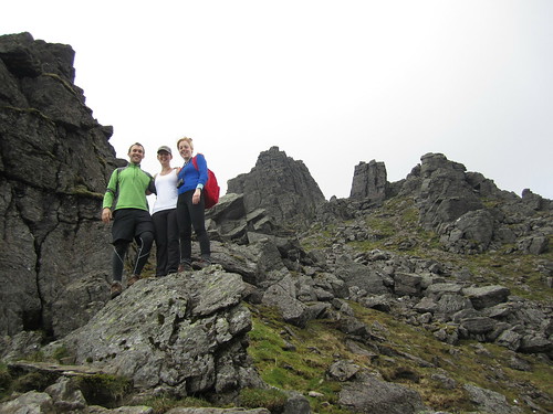
Right, so continuing on this trend of finally writing backed-up blog posts, this one's a monster simply because of the photos I had to reorganise to get here! Last December, though, I had the great pleasure of being able to tag along and help teach a glacial geology and geomorphology field trip to the central region of New Zealand's South Island. Having been to the North Island and having experienced the northern- and western-most points of the North Island and explored the watery wonderland of the Bay of Islands, I was totally pumped to get to some of the more staggering New Zealand scenery we all know from Lord of the Rings!

After three hours of one of the most turbulent flights I'd been on in a while (and I'd just return to Sydney from a trip to Denver and Vermont), we landed in Queenstown, the adventure capital of New Zealand. The flight in over the Southern Alps was beautiful. Being early December, New Zealand was just emerging from winter and all of the mountains still had substantial snow on them! We wasted no time in picking up our three passenger buses and trailer, and with 24 student in tow, set right off out of Queenstown to the Kawarau Bridge, famous for being the original bungee jump in New Zealand. Of course, we were there to learn about New Zealand's past glacial geology, climate, and geomorphology - or how the landscapes develop and change through time. Along the first few days the students would be presenting small mini-reports on different aspects of these topics and we weren't letting any second go to waste!

After learning about New Zealand's loess deposits, accumulations of wind-blown dust that were deposited under colder dryer conditions during the last glacial period, we headed off the main highway, taking the Crown Range Road to Wanaka where we'd spend the first night. We stayed at a small hostel/motor park near the shores of Lake Wanaka, which fills one of the many glacially-sculpted valleys east of the Southern Alps, including Lakes Wakatipu, Ohau, Pukaki, and Tekapo. Early the next morning, I got up early for a short walk along the lake, looking out across to the beautiful Mt. Alta rising across the shores. Our destination by the end of the day was Mt. Cook Village in Aoraki/Mt. Cook National Park, but we had plenty of stops to make before calling it a day.

Clay Cliffs and Lupin
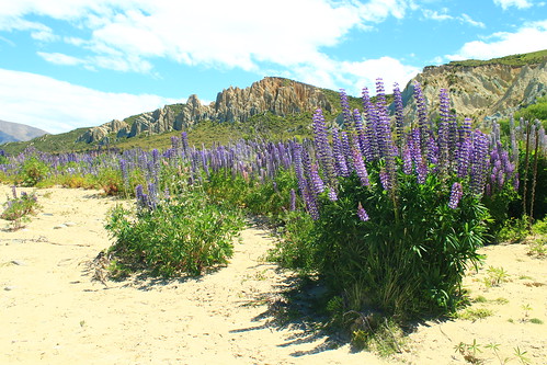
Purple lupin growing at the Clay Cliffs near Omarama
We took Lindi's Pass toward Omarama before doubling back across the Ahuriri River to the Clay Cliffs, a geological formation of very soft rocks exposed along the active Osler Fault. The cliffs are a deeply dissected feature that is the site of an ongoing battle between the uplifting tectonic fault and erosion. We stayed here for a short while and had lunch along the Ahuriri River, a beautiful place to dip your feet in the refreshing water and have a bite to eat. We made one more stop to the former river outlet of Lake Pukaki before it was dammed and diverted but also had time to stop at the southern end of Lake Pukaki to get a sense of what we were in for for the next few days.

Aoraki/Mt. Cook
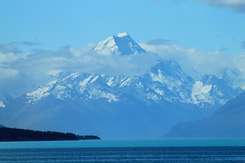
Aoraki/Mt. Cook (3,724 m/12,218 ft) looming over Lake Pukaki
The weather was bright and sunny and fairly few clouds against a blue sky, and from here, far off in the distance, was the brilliantly majestic peak of Aoraki (or Mt. Cook), the highest point in New Zealand at 3,724 meters (12,218 ft) above sea level! We had to stop here because the view was simply breathtaking, and because Aoraki is apparently often shrouded in clouds, we thought this might be our only chance to see its entire height! And I should mention Lake Pukaki because it was amazing in its own way. There is so much powdered rock, crushed by glacial erosion that gets washed into the lake that it takes on a very milky appearance which reflects the sky on a sunny day, turning it a turquoise colour that is really only best matched by a Crayola crayon of the same colour!

It was windy, so we got back into the vans and started the fairly long drive down the Mt. Cook Road toward Mt. Cook Village, the views along which were absolutely stunning. I'm jealous of the students in my van because they got to stare out the windows the entire time, while I had to keep my eyes on the road. But if you want a fun road to drive along, this is one of them. It just rolls and wraps its way long the lake and the ever-impressive Southern Alps just keep looming in the distance! Well, if the drive wasn't thrilling enough, once you're past the head of the lake, you begin driving through the wide and flat river valley that drains the Mueller, Tasman, and Hooker Lakes which are all fed by glaciers. And while you can't see the glaciers, as they are hidden by huge glacial moraines and tucked away around the mountains, you do see the incredible wall of ICE that is known as the Huddleston Glacier, which frankly, I thought was one of the most impressive things I've ever seen! It's just this massive, steep wall of ice that you just couldn't stop looking at!


Aoraki/Mt. Cook National Park
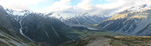
Looking down to the Mt. Cook Village from the Red Tarns. The Huddleston Glacier is the big wall of ice plastered
on the side of the Southern Alps in the distance. Mueller Lake and its end moraine seen in the bottom of the valley.
Aoraki (the Maori name for Mt. Cook) features prominently in Maori history. The Maori people believed the South Island to be a canoe that Aoraki and his brothers were using to voyage the world. It tipped and the brothers climbed onto the top of the overturned canoe and turned to stone. Geologically, Mt. Cook is positioned in the Southern Alps which are the result of convergence along the Alpine Fault which is the boundary between the Indo-Australian tectonic plate and the Pacific plate. The fault is mostly a dexteral strike-slip fault, but there is oblique convergence which has uplifted the mountains on the South Island. It is the Alpine Fault that causes most of the earthquakes in New Zealand, and also as it cuts across the north part of the South Island it goes offshore east of the North Island where subduction of the Pacific plate under the Indo-Australian plate results in the volcanism the North Island is famed for!

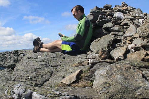
Well, while all of the students were excited to get out of the vans and start eating and drinking for the night, I had picked up a wee trail map and having heard that weather is rarely clear in the park, I thought I'd take advantage of it by doing a short hike up to the Red Tarns, some small ponds perched high up the mountains above Mt. Cook Village. Luckily summer in the Southern Hemisphere means plenty of light late into the evening, so I didn't have much to worry about - other than breaking my ankle with no one around! Well, the hike up was unrelentlessly steep, but I eventually made it to the tarns, which in and of themselves aren't that impressive, but you don't make that kind of hike to look at a pond, but for the view of the rest of the valley. Up here, you're so high up above the valley that you can see up and over Mt. Wakefield to Mt. Cook as well as up the Tasman River valley to The Armchair and Malcher Peak. The weather was holding up, so I decided to climb even higher to the shoulder of Sebastopol, the lowest peak in the National Park. Catching my breath, I decided my hunger would win over my want to reach the summit, so I raced down a big scree slope and headed back to dinner at the Mt. Cook Village.


Aoraki/Mt. Cook National Park
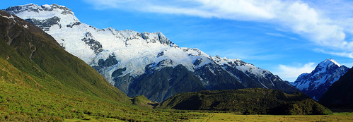
The Huddleston Glacier and Mt. Sefton (left), Aoraki/Mt. Cook (right), and the Mueller
Glacier's end massive end-moraine (centre-bottom)
Weather was clear the next morning again, blue skies and few clouds, so I walked up toward The Hermitage - the famously fancy resort hotel in the National Park that looks directly over to Mt. Cook - for a few morning photos before joining back up with the students. We drove up to the Mueller Glacier overlook for a few more student talks. During one of the talks, we all of a sudden heard this huge crack that sounded like thunder, followed by a cascade of booms and crashes. It was so startling that everyone turned their heads to the glaciers behind us. Though we couldn't see anything, it was pretty obvious we'd just heard a massive block of ice break off the Huddleston Glacier, falling down onto the Mueller Glacier below. Coincidentally, the student giving his report was just talking about ice falls. Talk about timing!

Blue Ice
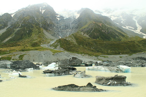
Icebergs from the Hooker Glacier floating in Hooker Lake
Once the student talks were done, we started the long hike up to Hooker Lake and the Hooker Glacier that sits right at the base of Mt. Cook. We continued to hear booms of breaking ice behind us during the hour-long walk up to Hooker Lake, which was cool, but the weather turned, which was not. We could see the clouds rising up from the west and flowing over the mountain tops to our left as the wind picked up and threatened to rain us in. But, being geologists, we go out in anything and this certainly didn't stop us and the last few students presented their mini-reports. You couldn't really see the mountain peaks by this point, but you could still get great views over Hooker Lake which was just chockers full of icebergs in various stages of melting, all shapes and sizes! By the time we left Hooker Lake, the weather had cleared up once again, permitting us to drive around to the next valley over to the Tasman Glacier and Lake.

Tasman Glacier and Lake Panorama
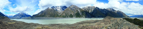
Lake Tasman is a recent feature to the landscape, having only formed in the last 40 years after the Tasman Glacier (left)
retreated to its current position!
Lake Tasman is impressive, if not for its size (7 kilometres long!), for the fact that 40 years ago, it was not there! Forty years ago the Tasman Glacier's terminus was at the lookout most visitors take the short walk up to from the car park. Now, however, Tasman Glacier ends in the lake and icebergs calve off its front. Though the retreat is impressive and offers the opportunity to take speed boat tours around the lake, it just means our changing climate is killing off these magnificent glaciers!

We headed back out of Aoraki/Mt. Cook National Park toward the town of Twizel where we'd be based for the remainder of the trip. Over the next 5-6 days, the students would be working on small group projects in the area, and we, the trip leaders, would drive them wherever they needed to go. But first, we had another stop to get to up beyond Lake Ohau on the other side of Twizel. By the time we got beyond the shores of Lake Ohau, the weather came back with a vengeance.

The next day was fairly uneventful. The rough weather had cleared up and the students used the day to plan their projects. Twizel itself is a pretty dull town. It was founded as a working camp during the construction of the dams that were built on Lake Ohau, but remained a popular stopover point for travelers going to Mt. Cook (not to mention cheaper than staying in Aoraki/Mt. Cook National Park. While there are some nice coffee shops and cafes in the main shopping area, there isn't much to speak of - especially of the locals. While eating dinner at the Power Station Bistro I noticed one man down his beer outside and promptly walk to a short brick wall and urinate on it! Welcome to Twizel, indeed!

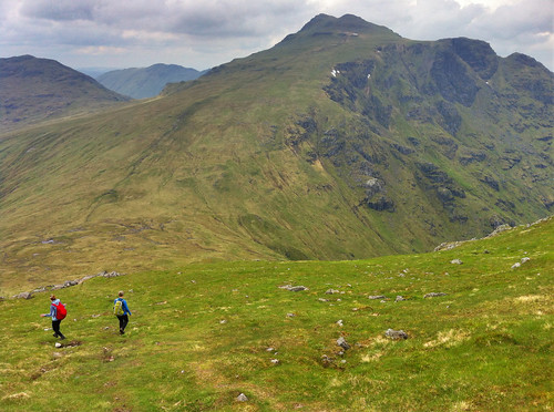
I played chauffer for students heading up back into Aoraki/Mt. Cook National Park over the next three days to collect data for their projects. Depending on which group was where, and when they needed to get to their next stops, I often had anywhere from an hour to a few hours by myself before I had to meet any of the students and move them. This was nice because it gave me time to do a few shorter walks and explore the park a bit more. One of the days I walked up the Mueller Glacier trail to see the head of the glacier which had retreated around the corner of its valley, out of sight from the main view point. Right at the bottom of the Huddleston Glacier. No one else was up this far and I enjoy sitting in the sun in the middle of this amazing landscape. I felt so fortunate to be able to experience it in all its sun-shiny glory!

Hooker River and Bridge
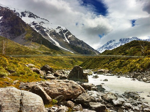
Suspension footbridge over the Hooker River. Aoraki/Mt. Cook shrouded in clouds
I also joined a few student groups on their quests to collect field data. This varied from walking up along the crest of the lateral moraine along the edge of Tasman Lake looking for students who had gotten well-ahead of me, helping students measure boulder dimensions in streams coming down from creeks draining the steep valleys to the west of Mt. Cook Village, and taking one more walk up to the iceberg choked Hooker Lake.

I had no plans to see any more of the South Island on this trip, and though I was a bit let down about not being able to do that before arriving, I don't think I could have asked for a more amazing experience that just being able to wander and explore the Hooker and Tasman Valleys in Aoraki/Mt. Cook National Park. It really must be one of the most spectacular landscapes I've been to. It's drastic, but accessible; staggeringly expansive, but easy to get around; busy with tourists, but big enough that you don't have to go far to get away from them!

Queenstown Pianist
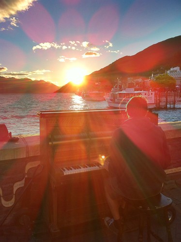
Pianist playing his own music during a beautiful Queenstown sunset
over Lake Wakatipu
The students had a final day in Twizel to write up and hand in their reports, so the last day near the mountains wasn't all that exciting. Finally, we were ready to leave Twizel and made the long drive back to Queenstown for our last night in New Zealand. We arrived early afternoon and many of us had previously signed up to go whitewater rafting to celebrate the end of a long week. We dropped our things off at the hostel and met down in the town at Queenstown Rafting where we were fitted up with wetsuits and packed into large vans with a trailer packed with rafts in tow behind us. This is no big deal, except to get to the launch site, we had to drive down Skippers Road, a long, very tightly-winding road that is cut into the side of mountains with very steep slopes! To put it in perspective, if you sat next to the window, you couldn't see the edge of the road and it looked like there was nothing beneath the van! In fact in one or two places, there almost wasn't anything beneath the van... One tight turn has been so abused that the edge of the road has eroded to the point that side of the van on the inside of the road gets scratched by the rocks sticking out of the slope! At another point on Skippers Road, the road appears to be intact, but when you look back up at it from the river, you see that a big chunk of rock, that would otherwise support the road, has simply fallen away! If you're afraid of this kind of driving, there's no hope for you because no matter which side of the van you sit on, you're going to be exposed to one of these hazards!!!

But the rafting itself was awesome! I've only been whitewater rafting once before on the New River in West Virginia where the water levels that year were low enough that the big rapids had diminished many of the rapids, so I wasn't sure what to expect. Well, the Shotover River is pretty much a narrow, narrow canyon with rocky cliffs on either side and in most places the river is as wide as the raft! I've got to give it to the raft guides because they have some of the hardest jobs in the world in keeping us all safe! While we didn't flip, like we did on the New River, there were so many times I thought we were goners! Two girls did fall out at one point, but we safely got them back on the raft just before they were pinned between the rocks and raft! The trip culminates a tunnel that was blasted into the mountianside to funnel water for gold mining in the mid-1800s, the final rapid is shooting down the mill run right where every raft in front of us was waiting and watching, hoping someone would flip. We didn't, but had a great time and it was an awesomely adventurous way to end a week in New Zealand!

That night was spent out in Queenstown watching a beautiful sunset over Lake Wakatipu and eventually some mechanical bull-riding in one of the town's innumerable options of Western/Cowboy-themed bars. Flights back to Sydney the next afternoon gave me a little bit of time to walk around the local Saturday markets along the lakeshore in what ended up being a very nice sunny relaxing way to end my last visit to New Zealand in a long time! Definitely not the last, but a long time at least!

Saturday, June 7, 2014

Scotland: Beinn Narnain, Beinn Ime, and Ben Vorlich (Munros 3-5)

Beinn Narnain and Beinn Ime

Date: 27 May 2014

I've said it before, but it's worth saying again: when the weather is nice in Scotland, you've got to go take advantage of it! Luckily, as a student, as long as my work gets done on time, it (kind of) doesn't matter when I do it. So when the sun comes out, it's time to go! A few weeks ago, my classmates Hazel and Ruth and I headed off to Arrochar, west of Glasgow near Loch Lomond to hike a few of the Munros in the Arrochar Alps. It was supposed to rain a little bit in the afternoon, but it was clear now and we decided to take the steeper route to the summit of Beinn Narnain and get that over and done with first, figuring if it was rainy later, the steep slope would be too slippery to come down.

It was the right decision. The path up from the Argyle Forest Park parking lot to the summit is a long and tiresome, seemingly never-ending steep trail from sea level right up to 600 meters before it finally levels out for a little while. Once you're up and out of the forest, the views are magnificent and when you get to the part that levels out, stunning views of the craggy peaks of The Cobber loom into view.

The Spearhead
Final ascent up Beinn Narnain through The Spearhead
But of course with all hillwalking, there are about three or four "false peaks" that make it seem like you're almost there, but then...nope! One of these false peaks was the Cruach nam Miseag and we really thought we might be to the summit. Instead it was just a vantage point where we could see the trail go down in elevation before winding its way up between huge rock outcrops called The Spearhead! A few hikers were threading their way through The Spearhead and we could hear their voices echoing while we sat and had a wee break. The rest of the trail wasn't terrible, however. It turns out that getting up through The Spearhead didn't take long at all and as a geologist, the blocky and square outcrops that towered overhead were just fascinating!

After one last rocky gully we clambered up through, we found ourselves on the top of the mountain - not the summit yet, mind you, but it was a flat walk from here. We stopped for a few photos looking over Loch Lomond from the top of The Spearhead and eventually made it to the cairn and trig point at Beinn Narnain's summit of 926 metres (3,038 ft). We stayed up there a little while to catch our breath and had a good look around us. It was quite cloudy, but the sun poked through every now and again, and the cloud base was higher than the mountains, so we had good views of all of the other Arrochars and even Ben Lomond across the lake.

Beinn Ime
Over and down from Beinn Narnain to Beinn Ime. Looking
back at it, the trail up Beinn Ime just looks squidgy!
We could see the next mountain over, Beinn Ime, from the top of Beinn Narnain and decided that it didn't look too awfully far off. Besides, the walk down to the "bealach" (which I think is the name for the saddle between two peaks) and up to the top of Beinn Ime was smooth, looked fairly shallow, and quite grassy, so it couldn't have been that bad, right?

While getting down to the bealach from Beinn Narnain wasn't bad, the bealach and the majority of the slope up to Beinn Ime was totally waterlogged from rain we'd had the previous few days. It wasn't all that warm, and soon conditions became worse as our feet sank into soggy, squidgy, grass, and our socks became soaked with cold water. As Hazel put it, it was a long plod. We didn't talk much and instead just kept one foot in front of the other until the path hardened underfoot and became more clear up at the higher elevations. A walker coming down the mountain told us we weren't too far off, and sure enough, the trail quickly leveled off and we walked along the ridge to the cairn at the summit of Beinn Ime, the highest of the Arrochar Alps at 1,011 metres (3,317 ft). Being so high, it was really windy, but luckily previous hikers had created a sort of a fortress around the cairn that blocked some of the wind, so we sat there having our lunch with the best view around!

It was windy and chilly enough, and our feet were still wet, that we didn't stay for too long and started the long plod down the mountain. Fortunately, the trail back to the car looped down the valley between Beinn Narnain and The Cobbler, so we didn't have any more walking upslope. We stopped for some snacks at some large boulders at the foot of The Cobbler but didn't stay too long. The rain came in just as we were getting back to the car, so while we weren't too wet, it did get us in the end. Good thing we hadn't gone down the real steep slope we started on!

(there's more below the slideshow)


Ben Vorlich

06 June 2014


I decided to trade my Friday for my Saturday and since it was sunny on Friday, head off to the one last remaining Munro in the Arrochar Alps I'd yet to tackle - Ben Vorlich. I'd seen Ben Vorlich from my hikes up Ben Vane and the Beinns Narnain and Ime, and the reviews from Walk Highlands said to expect a steep and unrelenting climb to the summit ridge. The reviews were not joking! Luckily, I was hiking on my own yesterday, so I could take my own pace. Once I found the trailhead, as the reviews said, it just goes up. And up. And up. Though the trail is well-defined, it is not just steep, but wet, and mucky. So much so that one misstep could mean face-planting it into the hillslope which would not be good because there were a lot of rocks, too!

Ben Vorlich Summit
Ben Vorlich - a good place to have a read!
The walk up the slope gets you about 400 metres in elevation over the valley below, and even though the trail started to cut over along the side of the mountain, it sure didn't feel any less steep. The views started to get amazing though as the low clouds all around me started to clear. And near the top of the slope, massive rock outcrops and cliff-forming bedrock created an awesome geologic playground to be walking through! Even the mucky trail was shining with the weathered mica minerals that reflect sunlight so well.

Well, eventually the trail flattens out, kind of, but there is still a ways to go to get to the summit. And even when you get to the trig point, you're still not there because the actual summit is another short walk beyond! But once you're there, you know you're there - 943 metres (3,094 ft) is hard to miss! Not too many people were up at the summit, so it was nice and quiet. And though it was a bit windy, I was able to find a little crevice between some rocks, out of the wind where I could have my lunch and finish reading a book I've been trying to get through. It was so much nicer having time to enjoy the peace and quiet of the summit, rather than being rushed to get to the next one or forced off by inclement weather.

Trig Point Panorama
The panoramic planet I stitched together from the trig point
on Ben Vorlich
But soon enough, I felt it was time to start heading back down to the car park at Inveruglas where I'd been dropped off by the CityLink bus and was getting picked up from them, too. By the time I started walking down the weather was pretty much sunny and warm and I took my time with photography experiments and some of the best Loch Lomond scenery I've seen yet! The trail down the slippery slope I started on wasn't too bad going down, though I did slip a number of times, but before I knew it I was back down heading to the car park with plenty of time to spare. When I got there, the sun was warm on the rocks at the lake's edge, so I found a good comfortable spot, took off my boots and finished my book. Great day away, but tomorrow will have to be a work day. I just hope it actually rains so I don't feel guilty for taking a Friday off!

Creative Commons License
This work by Eric W. Portenga is licensed under a Creative Commons Attribution-NonCommercial-NoDerivs 3.0 Unported License.