Travel Date: 18 August 2013
It was a rough morning trying to wake up on time and be out in front of the YHA Alice Springs in time to be picked up for my 3-day adventure in the Outback. Though I originally wanted to rent a 4WD and do the trek from Alice Springs to Uluru with friends, I wasn’t able to convince any of my friends to come along on this trip with me and I sure as hell wasn’t about to tempt fate by doing it on my own because with some of my travel luck, I’d inevitably get bogged down in some sand, run out of water, and get bitten by a snake trying to find a cell signal! So I booked a 3-day tour of some of the Outback’s most famous sites.
WayOutback tours offer a number of trips ranging from 3 days to over a week, some of which are more rugged than others. The one I’d booked was “all inclusive” in the sense that all food was provided for, sleeping arrangements were already made, and all I had to do was show up, sit down in the bus, and enjoy the scenery. Soon enough, a big…truck? I’m not entirely sure how to describe it. It was a vehicle that had the front cab of a small semi-truck and instead of a cargo hold on the back, it had a relatively small coach like a charter bus with big windows and two seats on either side. The bus accommodated 24 people and was jacked up on big 4WD tires.
Our driver, Adam, helped the two of us being picked up put our luggage in the storage hold on the back of the bus. It took us a while to pick up everyone else from their respective hotels and hostels around Alice Springs, but soon enough we had a nearly full bus with people from all over the world: an American girl, her father, and her Swedish friend, a hip-hop dance teacher from Amsterdam, a girl from Glasgow, an adventurous guy from Vancouver, and your typical handful of German and French backpackers.
The bus was chatty at first as we all were introducing ourselves and going through the typical banter common amongst backpackers in Australia, but it was still pitch black out and we had a good 6-hour drive ahead of us and soon enough everyone was sleeping.
The thing anyone needs to know about the Northern Territories is that there are very very few towns and everything is incredibly far apart! When you drive down the highway and come across a petrol station or bathroom, you stop and fill up and use the bathroom because you never know where the next one will be. Between the towns are small roadhouses that usually have a gas station, some hotel rooms, camping spots, toilets, and a bar.
Our first stop was at one of these roadhouses, the Stuart’s
Well Roadhouse, and it was the first chance we had to stretch our legs, and
grab a coffee. This roadhouse was unique in that it also had a number of pens
where Australian animals like emu, kangaroos, and various birds were on display
for tourists stopping in. But they also had two of the more unique sights in
the Outback: camels and a dingo. Camels are obviously not native to Australia,
but were imported from the Middle East because of their hardy survivalist
instincts in desert environments and the preferred cargo animal over horses,
which require a lot of water. A transcontinental telegraph cable was built from
Adelaide to Darwin with Alice Springs being used as a transfer point along the
way. Camels were used by the crew that laid down the cable. But like many
non-native animals in Australia, some of the camels escaped and proliferated in
the desert and today there are over one million wild camels roaming Western
Australia and the Northern Territories. Dingoes were also introduced to
Australia over 40,000 years ago and have also adapted and proliferated
throughout the continent and have just recently been described as a separate
canine species and not just a variety of wild dog. The one dingo at this
roadhouse was old and used to tourists, so was not caged up and was pretty
snoozy and docile.
Adam, our driver, didn’t let us linger too long as we still had a long ways to go. We drove another few hours to the Erldunda Roadhouse for another bathroom break, and turned off the Stuart Highway onto the Lasseter Highway toward Uluru.
Most people have visions of Australia’s Outback as being rocky with lots of sandy deserts, dry eucalypts, and brilliant soils stained red by the rusting of iron in the dust and soil. These images are spot on what you actually see and it is beautiful! Nothing but flat land as far as the eye can see until a few low-lying rocky ridges or mesas rise up in the distance, like Mt. Conner. But I was surprised at just how green it was! The trees were, by no means, lush and foresty, but the gum trees here were not as brown and dry as I thought they would be – really a testament to just how well-suited for every microclimate in Australia these trees are!
We pulled off the main road shortly before the Curtin
Springs roadhouse to collect some firewood for our campfire that night. Part of
the reason why I booked this particular tour is that while everything was
catered for us, we still had to participate in collecting firewood, preparing dinner,
and washing up dishes. It gives you that little tinge of roughing it! Like
anything in Australia, simple tasks, like collecting firewood carry inherent
dangers. Out here, it was snakes. Some of the world’s most deadly snakes are
found throughout Australia, but exceptionally potent ones here in the Outback.
We had to be very careful when picking up dead wood that no snake was sunning
itself nearby! But soon enough we had our firewood, and we made our pit stop at
Curtin Springs, and carried on west to Uluru.
There were a lot of rocky plateaus and mesas in the distance along the Lasseter Highway and every time we thought we saw Uluru, Adam would shake his head and assured us and assured us, “You’ll know when you see it!” And sure enough, another few hours down the road, the rock loomed into view, dwarfing any and all other mesas we’d seen! Everyone knows what Uluru looks like as it’s one of the most photographed rocks in the world. And with good reason! It’s the world’s largest monolith – or single rock, and it juts up from the flat Outback surroundings to over 300 m in height. We kept driving closer and closer and Uluru kept getting bigger and bigger. Finally, we pulled into our campsite in Uluru-Kata Tjuta National Park.
I couldn’t wait to get up close with the massive rock, but it was going to have to wait a bit. A few more people were joining our tour, but were flying directly in to the airport at Uluru, rather than Alice Springs, so Adam gave us directions for lunch and he left to pick up the others. Soon he came back with a French family that had a few kids with them, and a blonde girl from Canada who was finishing up teaching fashion at a school in the Melbourne area. I’m not entirely sure if she knew what she was signing up for. Everyone else was dressed in hiking and outdoor gear and those of us who’d collected firewood were already covered in dust, whereas the Canadian fashionista rocked up in a flowy sequined top, hair done up like a pro, and flip flops more appropriate for a cocktails near the beach than heavy walking in the Outback!
With lunch in our stomachs, Adam gave us the cultural sensitivity talk about Uluru. The rock features in numerous Aboriginal stories about Tjurkupa – the creation time of the world – and is a very sacred site as it is the birthplace of the Anangu people who still reside at Uluru. As European Australians had a penchant to do, they named the rock after the Chief Secretary of South Australia (Ayer’s Rock) and it became known as Ayers Rock – Mount Olga National Park, under the government of the Northern Territories until 1985 when the park was given back to the traditional owners of the land and renamed Uluru – Kata Tjuta National Park. One of the most popular things to do at the park is to climb to Uluru’s summit and there is only one trail to the top, but because of Uluru’s sacred importance to the Aboriginal communities, doing the climb is not recommended by any of the tour companies who have access to the park, though they all allow the tourists the option.
As a geologist and someone who loves a good hike, I was
really tempted to do the climb, but when our bus pulled into the parking lot
and we saw a full charter bus-full of tourists swarming up the trail to the
summit and I just felt sick from the blatant disrespect for this sacred site. A
small group from our bus decided to do the hike, and I understand their
decision, but I thought that in the long-run, I’d feel better knowing that I
hadn’t tread on sacred ground without fully understanding its importance to the
local people. Thousands of people do the climb each year and some of them even
feel the need to pick up a little stone and take it home as a souvenir from
Uluru. In the National Park’s Visitor Centre, though, there is a binder full of
letters from people who, after taking the stones from Uluru, experienced so
much bad luck and racked with guilt that they mailed the stone back to the park
in an effort to rid themselves of their curses. These small rocks are now
collectively known as Sorry Rocks.
While the hikers did the climb, the rest of us did the short Mala Walk to Kantju Gorge. Uluru has a lot of curves creating alcoves along its base which are perfect for allowing water to pond and gives the appearance of little oases in the Outback. The Mala Walk took us past a number of sites that are featured in the creation stories of the local Anangu people. Some of the rock caves at Uluru’s base contain carvings and petroglyphs that are thousands of years old. The trail leads you to Kantju Gorge which features a small water hole at the base of a cascade of steps that have eroded into the steep sides of the rock over millennia.
By the time we got back to the parking lot, the hikers hadn’t yet returned, so the rest of us drove around to the Mutitjulu Waterhole around the other side of the rock where there is an even bigger waterhole and forms in the rocks tell the story of Kuniya, a python woman who had traveled from the east. Kuniya’s nephew had been killed by the Liru, poisonous snakes. When Kuniya arrived, she exacted revenge for her nephew by taking her walking stick and striking the Liru with it, killing him.
The day was getting on and sunset wasn’t far away. Next to the Uluru climb, one of the most popular events every day is to watch the sunset on Uluru. The bright orange sandstone takes on a new life as it’s shadows and colours change in the dimming light. Our bus pulled into a parking lot that was just swarming with tour buses and vans, each with their own cohorts of tourists sitting around make-shift tables while everyone sipped on champagne and snacked on finger-foods while watching one of the most beautiful sunsets in the world. The bright orange rocks faded in and out of various hues of red and pink as the sky behind it darkened. The shadow of the western horizon slowly works its way up the rock until the final moment when the only the tip of the rock is illuminated a gentle pink colour before the shadow envelops the entire rock. Even with all the people around, I was able to take a little walk down a path where there were far fewer people and the whole sunset just becomes a peaceful experience leaving little doubt that this gigantic rock is indeed an intensely spiritual place.
With the sunset over, we bussed back to our campsite where some of our group got a campfire started so we could cook dinner while the rest of us started to prepare our beds. There were large stationary tents at the site, but the weather was wonderfully mild and we all had the option of sleeping in swags under the stars. Swags are nothing more than a big canvas bag that has a rough sleeping pad inside and you then put your sleeping bag in the swag on the pad. A canvas flap can then be pulled over your head in case it were to rain. Swags feature heavily in Australian culture, most notably in the song “Waltzing Matilda” in which Matilda is actually the name of the man’s swag! I don’t think I ever met a respectable Australian who didn’t have a swag or hadn’t spent a night in one. Being in the middle of the Outback, at Uluru, there was, for me, little choice about spending a few nights sleeping under the countless stars in my swag.
With our stomachs full of food and beer, it wasn’t long before everyone was comfortably in their swags (or uncomfortably in the case of our Canadian fashionista!) and fast asleep. It wouldn’t be too long, after all, before we would wake up at 4 am for our next day’s worth of amazing Outback experiences!
It was a rough morning trying to wake up on time and be out in front of the YHA Alice Springs in time to be picked up for my 3-day adventure in the Outback. Though I originally wanted to rent a 4WD and do the trek from Alice Springs to Uluru with friends, I wasn’t able to convince any of my friends to come along on this trip with me and I sure as hell wasn’t about to tempt fate by doing it on my own because with some of my travel luck, I’d inevitably get bogged down in some sand, run out of water, and get bitten by a snake trying to find a cell signal! So I booked a 3-day tour of some of the Outback’s most famous sites.
WayOutback tours offer a number of trips ranging from 3 days to over a week, some of which are more rugged than others. The one I’d booked was “all inclusive” in the sense that all food was provided for, sleeping arrangements were already made, and all I had to do was show up, sit down in the bus, and enjoy the scenery. Soon enough, a big…truck? I’m not entirely sure how to describe it. It was a vehicle that had the front cab of a small semi-truck and instead of a cargo hold on the back, it had a relatively small coach like a charter bus with big windows and two seats on either side. The bus accommodated 24 people and was jacked up on big 4WD tires.
Our driver, Adam, helped the two of us being picked up put our luggage in the storage hold on the back of the bus. It took us a while to pick up everyone else from their respective hotels and hostels around Alice Springs, but soon enough we had a nearly full bus with people from all over the world: an American girl, her father, and her Swedish friend, a hip-hop dance teacher from Amsterdam, a girl from Glasgow, an adventurous guy from Vancouver, and your typical handful of German and French backpackers.
The bus was chatty at first as we all were introducing ourselves and going through the typical banter common amongst backpackers in Australia, but it was still pitch black out and we had a good 6-hour drive ahead of us and soon enough everyone was sleeping.
The thing anyone needs to know about the Northern Territories is that there are very very few towns and everything is incredibly far apart! When you drive down the highway and come across a petrol station or bathroom, you stop and fill up and use the bathroom because you never know where the next one will be. Between the towns are small roadhouses that usually have a gas station, some hotel rooms, camping spots, toilets, and a bar.
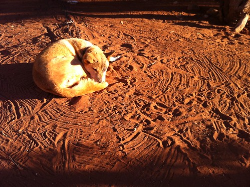 |
| Sleeping dingo at the Stuart's Well Roadhouse south of Alice Springs |
Adam, our driver, didn’t let us linger too long as we still had a long ways to go. We drove another few hours to the Erldunda Roadhouse for another bathroom break, and turned off the Stuart Highway onto the Lasseter Highway toward Uluru.
Most people have visions of Australia’s Outback as being rocky with lots of sandy deserts, dry eucalypts, and brilliant soils stained red by the rusting of iron in the dust and soil. These images are spot on what you actually see and it is beautiful! Nothing but flat land as far as the eye can see until a few low-lying rocky ridges or mesas rise up in the distance, like Mt. Conner. But I was surprised at just how green it was! The trees were, by no means, lush and foresty, but the gum trees here were not as brown and dry as I thought they would be – really a testament to just how well-suited for every microclimate in Australia these trees are!
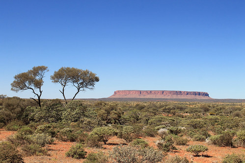 |
| Mt. Conner off in the distance near Curtin Springs |
There were a lot of rocky plateaus and mesas in the distance along the Lasseter Highway and every time we thought we saw Uluru, Adam would shake his head and assured us and assured us, “You’ll know when you see it!” And sure enough, another few hours down the road, the rock loomed into view, dwarfing any and all other mesas we’d seen! Everyone knows what Uluru looks like as it’s one of the most photographed rocks in the world. And with good reason! It’s the world’s largest monolith – or single rock, and it juts up from the flat Outback surroundings to over 300 m in height. We kept driving closer and closer and Uluru kept getting bigger and bigger. Finally, we pulled into our campsite in Uluru-Kata Tjuta National Park.
I couldn’t wait to get up close with the massive rock, but it was going to have to wait a bit. A few more people were joining our tour, but were flying directly in to the airport at Uluru, rather than Alice Springs, so Adam gave us directions for lunch and he left to pick up the others. Soon he came back with a French family that had a few kids with them, and a blonde girl from Canada who was finishing up teaching fashion at a school in the Melbourne area. I’m not entirely sure if she knew what she was signing up for. Everyone else was dressed in hiking and outdoor gear and those of us who’d collected firewood were already covered in dust, whereas the Canadian fashionista rocked up in a flowy sequined top, hair done up like a pro, and flip flops more appropriate for a cocktails near the beach than heavy walking in the Outback!
With lunch in our stomachs, Adam gave us the cultural sensitivity talk about Uluru. The rock features in numerous Aboriginal stories about Tjurkupa – the creation time of the world – and is a very sacred site as it is the birthplace of the Anangu people who still reside at Uluru. As European Australians had a penchant to do, they named the rock after the Chief Secretary of South Australia (Ayer’s Rock) and it became known as Ayers Rock – Mount Olga National Park, under the government of the Northern Territories until 1985 when the park was given back to the traditional owners of the land and renamed Uluru – Kata Tjuta National Park. One of the most popular things to do at the park is to climb to Uluru’s summit and there is only one trail to the top, but because of Uluru’s sacred importance to the Aboriginal communities, doing the climb is not recommended by any of the tour companies who have access to the park, though they all allow the tourists the option.
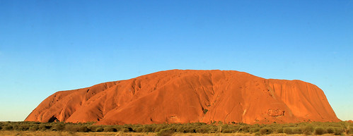 |
| Finally here! Uluru! |
While the hikers did the climb, the rest of us did the short Mala Walk to Kantju Gorge. Uluru has a lot of curves creating alcoves along its base which are perfect for allowing water to pond and gives the appearance of little oases in the Outback. The Mala Walk took us past a number of sites that are featured in the creation stories of the local Anangu people. Some of the rock caves at Uluru’s base contain carvings and petroglyphs that are thousands of years old. The trail leads you to Kantju Gorge which features a small water hole at the base of a cascade of steps that have eroded into the steep sides of the rock over millennia.
By the time we got back to the parking lot, the hikers hadn’t yet returned, so the rest of us drove around to the Mutitjulu Waterhole around the other side of the rock where there is an even bigger waterhole and forms in the rocks tell the story of Kuniya, a python woman who had traveled from the east. Kuniya’s nephew had been killed by the Liru, poisonous snakes. When Kuniya arrived, she exacted revenge for her nephew by taking her walking stick and striking the Liru with it, killing him.
The day was getting on and sunset wasn’t far away. Next to the Uluru climb, one of the most popular events every day is to watch the sunset on Uluru. The bright orange sandstone takes on a new life as it’s shadows and colours change in the dimming light. Our bus pulled into a parking lot that was just swarming with tour buses and vans, each with their own cohorts of tourists sitting around make-shift tables while everyone sipped on champagne and snacked on finger-foods while watching one of the most beautiful sunsets in the world. The bright orange rocks faded in and out of various hues of red and pink as the sky behind it darkened. The shadow of the western horizon slowly works its way up the rock until the final moment when the only the tip of the rock is illuminated a gentle pink colour before the shadow envelops the entire rock. Even with all the people around, I was able to take a little walk down a path where there were far fewer people and the whole sunset just becomes a peaceful experience leaving little doubt that this gigantic rock is indeed an intensely spiritual place.
With the sunset over, we bussed back to our campsite where some of our group got a campfire started so we could cook dinner while the rest of us started to prepare our beds. There were large stationary tents at the site, but the weather was wonderfully mild and we all had the option of sleeping in swags under the stars. Swags are nothing more than a big canvas bag that has a rough sleeping pad inside and you then put your sleeping bag in the swag on the pad. A canvas flap can then be pulled over your head in case it were to rain. Swags feature heavily in Australian culture, most notably in the song “Waltzing Matilda” in which Matilda is actually the name of the man’s swag! I don’t think I ever met a respectable Australian who didn’t have a swag or hadn’t spent a night in one. Being in the middle of the Outback, at Uluru, there was, for me, little choice about spending a few nights sleeping under the countless stars in my swag.
With our stomachs full of food and beer, it wasn’t long before everyone was comfortably in their swags (or uncomfortably in the case of our Canadian fashionista!) and fast asleep. It wouldn’t be too long, after all, before we would wake up at 4 am for our next day’s worth of amazing Outback experiences!


