Travel Date: 03 June 2012
(There is a slideshow with more of my photos from this post at the bottom of this page.)
As I was trying to go to sleep last night, I was worried I wouldn't be able to get around Orkney today for one reason: it's Sunday. In America, Sundays really aren't much different than the other days of the week; shops close at 7pm instead of 9pm and you can't buy booze in Michigan until after noon, but bus schedules and businesses typically stay open. This is not the case in Europe and
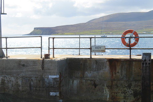
definitely not the case in Orkney. You get around Orkney on Sunday by your own vehicle (which I didn't have), a bike (which I couldn't get because the rental companies were closed), by hitchhiking (which I am reluctant to try), or by bus (which ran maybe six return journeys between Kirkwall and Stromness). Thus, my choice was clear - bus it was.
I got up early enough to take the bus into Stromness. I tried accessing the internet on my phone, which had a °-symbol where the 3G or E symbol usually is. As someone explained it to me, having ° is like having 2G (if there were such a thing). Regardless, I tried accessing the bike rental companies' websites to see if they were indeed closed on Sundays. The one was definitely closed, but I couldn't tell if Orkney Cycle Hire was open or not. So once in Stromness, I started wandering around the town, praying for a miracle, but deciding that Stromness wouldn't be all that bad of a place to get stranded for the day - afterall, the
Orkney Folk Festival was in its last day and there were plenty of musicians around.
Stromness is a beautiful town. There is only one main road going through the central bit with one or two smaller roads running parallel up the hill and multiple other spur-roads (they were more alleyways) that turned off the main street. The main road was narrow, only wide enough for maybe a car and a pedestrian, and was in-laid with flagstone and cobbles. Above your head, zig-zagging all the way from the end of town into the town square in front of the Stromness hotel and harbor is a strand of colorful pennants like the type you'd see strung around a car dealership's lot. It was early and not too many people were out, but then my prayers were answered as I saw a sign for
Orkney Cycle Hire and an arrow pointing to a patio where a man was walking out with a bike! I could rent a bike! I was
so happy because I really wanted to do my sightseeing and now I'd be able to! I paid for my bike, an 18-gear hybrid, and zoomed down the narrow, empty streets of Stromness to a wee general store where I picked up a few snacks for my day, and then pedaled out of town.
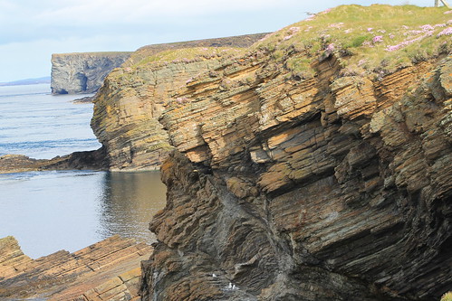
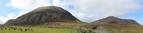
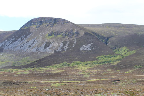
Orkney is not mountainous, so there are no really steep hills, but it's not flat either. I quickly learned that I was out of shape, though I soon got used to pedaling up the long inclines that are too steep to be flat, but too shallow to walk your bike up a short distance and coast down the hills. But it didn't matter, I was on two wheels, on an empty road, cycling past cows and sheep under a blue sky. My first stop was one of Orkney's do-not-miss sites that my Orkney Explorer pass covered entrance: the burial tomb of Maeshowe (pronounced
mays-HOW), which is part of the
Heart of Neolithic Orkney UNESCO World Heritage Site which includes all of the sites I had on my list. I got to Maeshowe only to be told that I was supposed to sign up for a tour time and that I could come back later that afternoon. I rescheduled for the following afternoon since my biking route wouldn't take me back toward Maeshowe that day again, but determined to carry on.
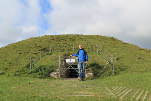
 |
| Maeshowe |
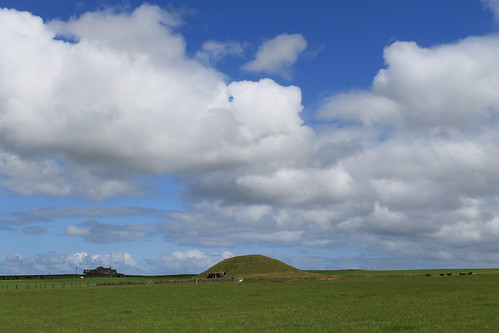
Just down the road from Maeshowe is a solitary standing stone called the Barnhouse Stone. It sits in the middle of a plowed field, surrounded by a square fence, maybe 3 meters on each side, so you can't really get to it, but interestingly, it is the smallest UNESCO-protected cultural site by area. Pretty cool!
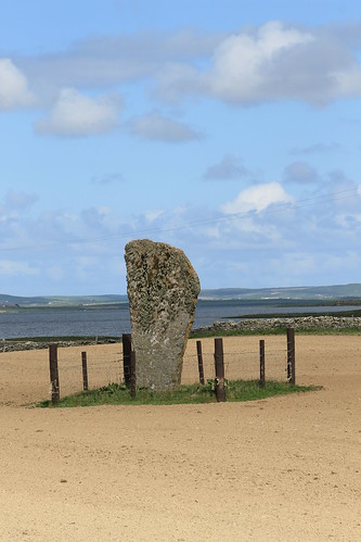 |
| The Barnhouse Stone |
Two large lakes dominate the landscape here and a low ridge separating them is home to a host of other neolithic sites, the next of which I visited were the Standing Stones of Stenness. Originally, there were 11 (maybe 12) stones, 5-meters high, in a circle surrounding a central hearth, all of which was surrounded by a deep ditch that was only traversed by an earthen causeway. The site, like Maeshowe, is nearly 5000 years old and is thought to have been a ceremonial site. A few meters away in one direction is the Watchstone, of the same age, and a few meters in the other direction is a recent discovery of a settlement, Barnhouse Village, also 5,000 years old.
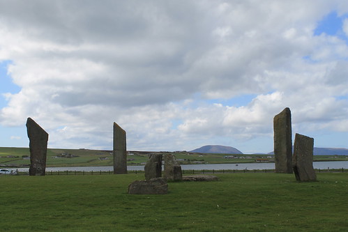 |
| Standing Stones of Stenness |
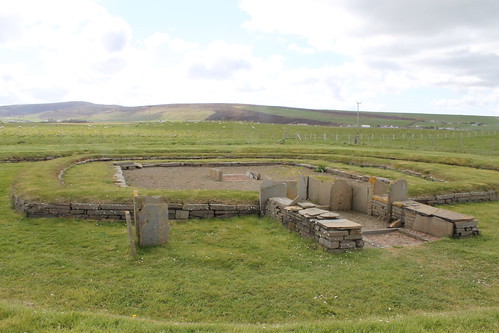 |
| Barnhouse Village |
Barnhouse Village was only discovered in 1984 by archaeologists who soon uncovered the foundations to eight structures including two ceremonial structures: one was larger than the other domestic structures of the village, and the other appeared to be two domestic structures fused into one - very much unlike the other structures here and at the nearby Skara Brae (see below).
In the same vicinity, sort of between the Watchstone, Stones of Stenness, and Barnhouse Village was yet another massive stone (the Odin Stone) that early drawings show having a hold carved through it. However, a non-Orcadian farmer moved to the site in the early 1800s and fussed that people were traipsing over his land, so he smashed the massive Odin Stone as well as some of the Stones of Stenness but was fortunately stopped by a massive protest by the locals. It is thought that this site in Orkney held particular significance of some kind due to the large number of sites being used at the same time including the Stones of Stenness, Barnhouse Village, Maeshowe, and the nearby Ring of Brodgar and Ness of Brodgar. It is even supposed that neolithic people from all over met at the Stones of Stenness for spiritual ceremonies here.
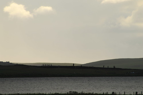
Down along the ridge that separates the two lakes (one of which is freshwater, while the other is salt water), past the Watchstone are even more neolithic structures. The Ring of Brodgar is a circle of stones, each of different sizes, shapes, and heights, on the perimeter of this wide henge (or flat circular area surrounded by a deep ditch). The site originally had 60 stones, only 27 of which are still seen today. I spent quite a while at the Ring of Brodgar taking it all in from many different angles, walking around its perimeter, and having my own guess at its purpose. I'm not sure what it is about neolithic sites that fascinates me. Maybe it's the fact that as a geologist, I'm drawn to stone structures? Maybe it's astronomical precision with which these stones are aligned? Maybe it's their antiquity? Maybe it's the fact that with all of our modern knowledge, we still have no clue as to what their purpose was? Maybe it's a combination of all the above; I'm not sure, but I could spend a very long time at these sites conjecturing.
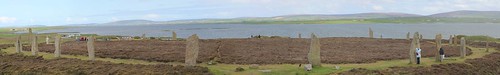 |
| Ring of Brodgar |
It started to drizzle and I decided to take off to the site that made me want to come to Orkney in the first place: Skara Brae. I first heard of the ancient village of Skara Brae while listening to Bill Bryson's book,
At Home: A Short History of Private Life, on tape driving to Michigan from Vermont last summer. I usually ear-tag pages in books I find interesting, but since I was driving, I couldn't do any more than search for some scrap paper and scribble down the name of this village, having no idea how it was spelled and hoping that I'd be able to decipher my scribbles later. Like the Barnhouse Village, Skara Brae was discovered by accident after a terrible storm struck the British Isles, killing hundreds of people. The storm ripped away the grassy field that covered this coastal site, revealing to the locals for the first time an intact village, 5,000 year old, with numerous dwellings and walkways connecting them. The dwellings all had the same internal plan, indicating that all inhabitants lived as equals to each other, and furniture including stone beds, dressers, hearths, and storage places were all intact. Unfortunately, some locals having a party in the nearby Skaill House decided to go investigate and knicked many of the original artifacts from Skara Brae.
Two things interested me about Skara Brae when listening to
At Home. Firstly, of all the dwelling places, there was one that while it was set up
just like the others was situated with a stone door to the entryway that could be shut and locked only from the outside. While the other houses at Skara Brae had doors, none were fitted with the locking mechanism, so it raises the question, what use could a seemingly peaceful community have for a dwelling place where someone could be shut and locked in? The second interesting bit that caught my attention was that some of the storage chambers at Skara Brae were fitted with drains and plumbing. Now, these weren't just stone alcoves with a hole in the bottom, but actual conduits leading away from the houses, draining into the ocean. It is remarkable that this society, older than Stonehenge and the Pyramids of Egypt, had the wherewithal to install drainage systems into their village, something that doesn't show up in other civilizations for another few centuries (and very far away, at that!).
Actually visiting Skara Brae was amazing (oh, by the way, it's also covered under the Orkney Explorer Pass). I hadn't realized that all of the passageways connecting the houses would have been covered, but the ceilings were so low that one would have to crouch to navigate their way through. Also, while the houses were mostly set up the same way, one of the houses had a storage chamber behind their stone dresser, only accessible by crawling under the dresser shelves, as if it were a hiding place. So many questions to be answered but with excavation being complete at the site (once a historic site is designated a UNESCO World Heritage Site, no more excavation can be carried out), and much of the original artifacts having been looted, we can only rely on supposition based on excavations of similar sites elsewhere. It is fortunate the site actually
is protected, however, as coastal erosion in the Skaill Bay would have otherwise continued to eat away at the sand banks Skara Brae is built on, resulting in the site being lost to the ocean forever.
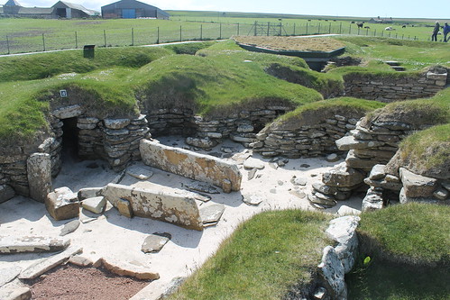 |
| Skara Brae |
Time was marching on and I needed to get back to Stromness in time to catch the last bus back to Kirkwall, so I hopped back on my bike and pedaled back to town. The bike ride back to Stromness was equally as beautiful as everything else I'd biked through. Orkney really is a biker's dream: wide, empty roads, quiet, with few cars passing (and those that do, even the tour buses, are sure to give you plenty of space and very non-threatening). My legs were happy to get a few nice long descents where I could just coast and talk to the cows and sheep as I went past.
With my bike returned, I did have a little time left to waste in Stromness, so I headed into the
Flattie Bar just at the base of the Stromness Hotel, ordered a Scapa Special (from the Orkney Brewing Company), and drank it outside amongst the people celebrating the last night of the Folk Festival, under the waving flag of the Orkney Islands.
I got back to Kirkwall around 5pm and decided to do some sightseeing in Kirkwall, too. Right near St. Magnus Cathedral is the Earl's Palace, which was built in 1606 by Earl Patrick Stewart, half-brother to Mary, Queen of Scots, who granted him the Crown estates of Orkney and Shetland. Earl Patrick was considered to be an evil man who eventually had to sell his palace to pay for some debts, was jailed in Edinburgh, and killed on accounts of Treason. The palace fell into the hands of the Orkney Bishop, whose palace itself was just across the courtyard, and at one point connected. All that remains of either palace now are the stone walls, the rest having been destroyed in retaliation for Earl Patrick's treason. You can still walk around the ruins of the Earl's Palace and the Bishop's Palace and even climb the stairs up to the tops of some of the towers where you are rewarded with magnificent views of the Cathedral.
My mother would have scolded me big-time if I didn't take time to stop in the cathedral, so that was next on the list. It is a massive structure, built from red sandstone found throughout the island. Originally a Catholic church, and the seat of the Bishop, it was converted to a Protestant church during the English Reformation, and stripped of all Catholic symbolism, which is why many of the windows are no longer inlaid with stained glass. The rose window at the end of the nave faces west, and at 7pm in the Orkney summer, the sun shines right through the rose window, splashing color over the insides of the church in a beautiful way. Unfortunately, the organ wasn't being played, which would have made the visit extra special.
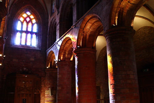 |
| Sunset illuminating St. Magnus Cathedral |
Finally, I was hungry and since it was still before 9pm, I headed to
Helgi's for a beef pie and some more local beers from the Highland and Orkney Brewing Companies (the Orkney IPA and Northern Lights). I chatted with some locals while watching the BBC coverage of the Queen's Flotilla down the River Thames in London for her Diamond Jubilee, and then with a young guy from Florida who was taking on an apprenticeship at the
Highland Park Distillery, which I'll have to visit next time I'm there.
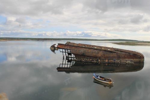
Before it got too late, however, there was one more thing I wanted to see, and I knew I wouldn't have time to get to it tomorrow: the Churchill Barriers. We'd driven across the barriers on the coach ride into Kirkwall from the ferry docks, but I wanted to get a better look, so I hired a cab to quickly take me out there and back. The Orkney Islands surround a large, well-protected harbor called Scapa Flow. During the World Wars, the British used Scapa Flow as a home-base for their naval fleet. At the end of WWI the German naval fleet was in surrender in Scapa Flow, waiting to hear the results of the Treaty of Versailles. The message that Germany surrendered did not reach the German Commander of the fleet by the pre-arranged time, so he ordered his entire fleet of 74 vessels to scuttle themselves so that their ships could not fall into the hands of the British, who watched in horror as the boats all began to sink into the depths of the water.
If that isn't a good enough story, Scapa Flow's WWII history is even better, if better is the right term. The British Navy was based up at Scapa during the war and was constantly on the watch for German u-boats who might try and break through one of the dozens of channels between the islands to get into the harbor. Churchill sank numerous vessels to block some of these paths, while installing underwater mines and anti-submarine nets at others. Many of these structures built to guard the island channels are still standing today, even. But the story picks up when a German u-boat commander got a hold of aerial photos of one of the channels and decided that he could squeeze his boat between one of the British vessels holding one side of an anti-submarine net and the shore. And this is exactly what happened. The u-boat nearly ran aground sneaking around the anti-submarine nets, but did make it into the harbor and after making a few rounds torpedoed and sunk one of the British Battleships before making its escape. Over 800 men lost their lives in the attack. After the attack, Winston Churchill sent Italian POWs up to Scapa to build massive cement blockades across some of the narrower channels, including the one the submarine sneaked through, and beefed up the security of all other entrances to the harbor. The last place I wanted to stop at was the Italian Chapel, a little church built by the Italian POWs while working on the Barriers as a place of worship.
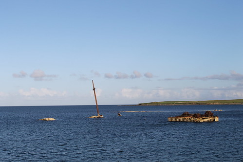 |
| Blockships sunk into entrances of Scapa Flow |
With that, the cabbie drove me back to Kirkwall where I quickly retreated to my hostel, cleaned up from the day, planned my timetable for the next day, and went to bed. I know this was a lot to do in one day, but like I said before, Orkney is a fascinating place with so much varied history, it's hard not to detail all I learned and my thoughts and experiences! Hopefully you made it to the end here, and you'll be rewarded with some nice photos below :)